Introduction
Lancashire has some of the Country's most spectacular Roman Roads and in
tracing them we will travel through some of Lancashire's finest countryside seeing many stunning views. There are very few sites in England where the Roman
Road surface has been exposed and put on display. Lancashire has one of them and
you can literally walk in the footsteps of the Legions!
It was reading an article by the former Deputy County
Surveyor of Lancashire, J M Whiteley, that inspired me to first produce web pages describing all Lancashire's Roman roads for Lancashire County Council 20 years ago. It was
possibly the first review to use the then new technology of GIS (Geographic Information System)
to combine old and modern maps, contour maps and aerial photographs from the 1940s, 1960s and the present. However, the last few years has seen a transformation in our understanding of Lancashire's Roman road network as a consequence of Lidar data becoming freely available. The use of Lidar data (basically high precision height data) to reveal the course of Roman roads has been a great success throughout the country. Imagery derived from this data is often able to show clearly the surviving remains of the road agger, terraces, side ditches and cuttings, often where they cannot be identified on the ground through traditional fieldwork. This has resulted in almost every road in Lancashire being located with high confidence. The raw Lidar data used here is courtesy and copyright the Environment Agency.
The original version of these web pages was available for many years on Lancashire County Council's web site. However, these pages were removed by LCC in December 2014 along with considerable other valuable historical information regarding Lancashire's highway heritage. The county no longer has aCounty Archaeologist - the cutbacks have taken their toll. So the opportunity was therefore taken to update everything and re-host them. Thanks are due to Peter Iles, the former Specialist Advisor for Archaeology for Lancashire, for his advice and ability to dig out obscure historical records. Thanks are also due to Mike Aerts for the use of his "MAGIC" software which turns raw Lidar numbers into pictures. If there are any mistakes then these are solely my (David Ratledge's) responsibility. Corrections and suggestions are always welcome.
For all the known routes in detail choose the appropriate page:-
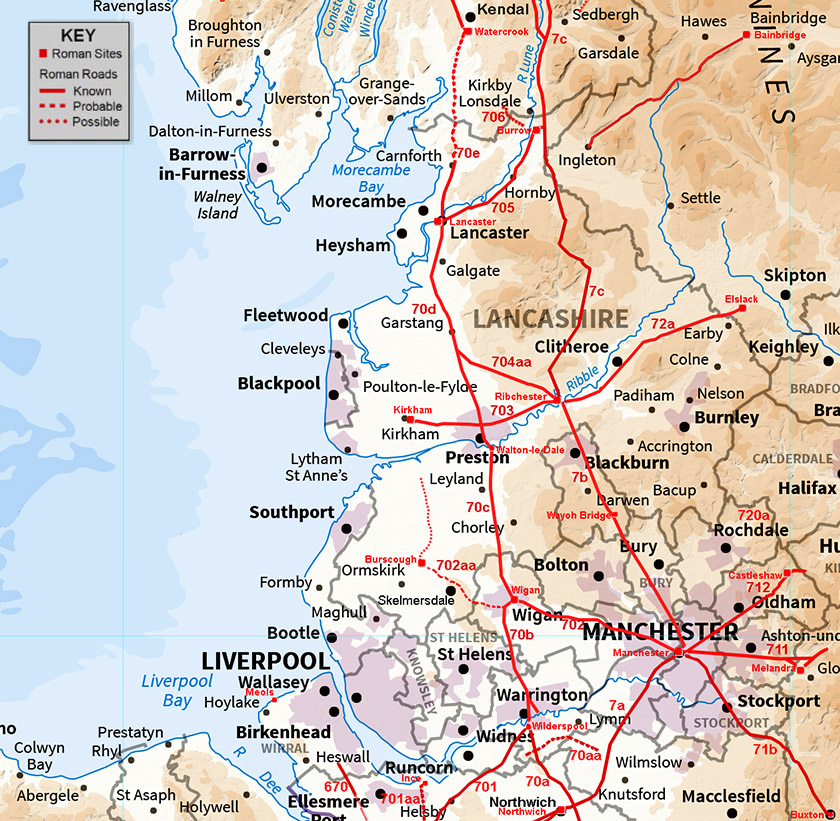
The "Coastal" North-South Roman Road
Wilderspool to Wigan, Margary 70b Generally well recorded but an alternative to the traditional circuitous route across Warrington is suggested.
Wigan to Walton-le-Dale, Margary 70c Route confirmed via Leyland with some Lidar evidence.
Walton-le-Dale to Lancaster, Margary 70d Route discovered at long last and what a surprise!
Lancaster to Watercrook, Margary 70e A likely route is emerging.
The "Inland" North-South Roman Road
Manchester to Ribchester, Margary 7b Route discovered at Edgworth and a probable NEW FORT!
Ribchester to Burrow, Margary 7c UPDATE 2021 - Route over the Bowland Fells - at last we have lidar and a big surprise!
The Croasdale Crossing (part of Margary 7c) Best Roman road walk in Lancashire.
Roads in West Lancs
Wigan to Burscough & Hesketh Bank, Margary 702aa The connecting road from Wigan to Burscough.
Burscough to Kirkham via Hesketh Bank The possible continuation of the above road to Kirkham via Hesketh Bank.
Roads around Ribchester
Ribchester to Elslack, Margary 72a Ribble Bridge site at Ribchester probably located and the River Calder crossing.
Ribchester to Kirkham, Margary 703 Clues as to the missing first mile emerge.
The Danes Pad (part of Margary 703) ....almost certainly does not exist and this web-page examines the (lack of) evidence.
Ribchester to Catterall (for Lancaster), Margary 704aa Newly discovered Roman Road. It only took me 45 years to find it! 2019 & 2022 excavation details.
Ribchester to Lancaster via Street, Margary 704 ....almost certainly does not exist but included for historical completeness.
Roads around Lancaster
Lancaster to Burrow, Margary 705 Route discovered to Caton and most of the the rest the route to Burrow. Updated 2020.
Burrow to North-West, Margary 706 Very speculative and Lidar has not solved the issues with this road.
Lancaster North Bank of River Lune One big clue but not much else.
Lancaster to Quernmore Looks Roman and a link to the Kilns there would have been needed.
Possible Roads
Possible Routes - sadly most are very doubtful with Lidar not adding any real evidence to support them.
Roads around Manchester (within former pre-1974 Lancashire county)
Manchester to Wigan, Margary 702 Thanks to Sibson and Watkin the full route is reasonably certain. Details of modern excavations and Lidar data confirming their route.
Manchester to Castleshaw, Margary 712 One minor (Lidar) update to the route worked out by the 712 Group plus a revised setting-out point at the Manchester end.
Manchester to Melandra, Margary 711 At long last we have the route located with high confidence!
Manchester to Buxton, Margary 71b Route to Hazell Grove looks reasonable but supporting evidence is limited. More certain from there to Buxton.
Manchester to Northwich, Margary 7a The route of the Chester road in detail.
Blackstone Edge Supposed Roman Road, Margary 720a Almost certainly not Roman but it will take years for this to become accepted.
General Info
Lancashire's Milestones Details of all 9 of Lancashire's Roman Milestones.
Road Construction Notes Britain's first engineered roads - how were they built.
Antonine Intinerary X Covers the north-west and at last we may have a solution.
References
References, Links, Copright Info and Contacts
> Return to Gazetteer
To contact David Ratledge regarding the Lancashire web pages, please email:
 |