|
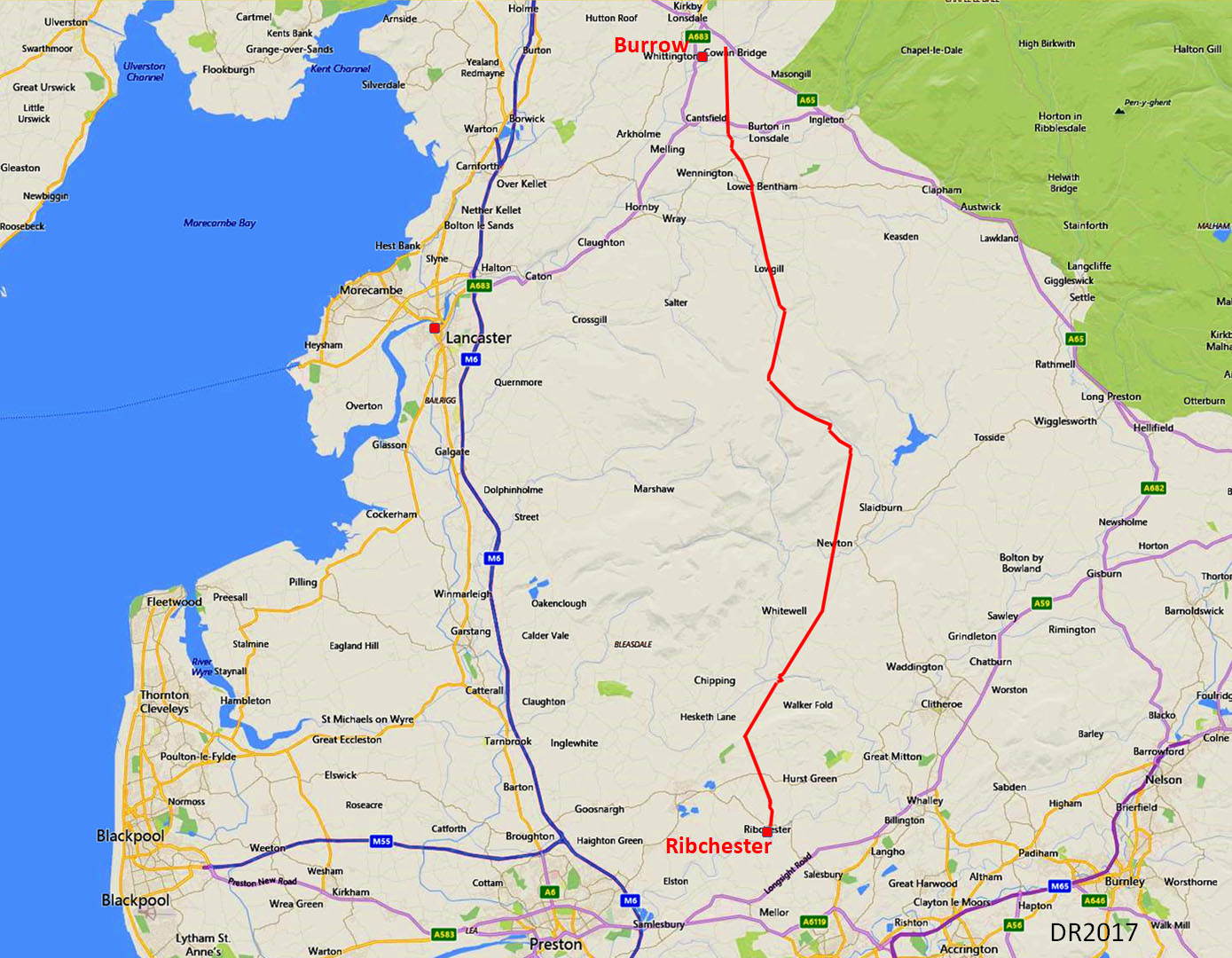
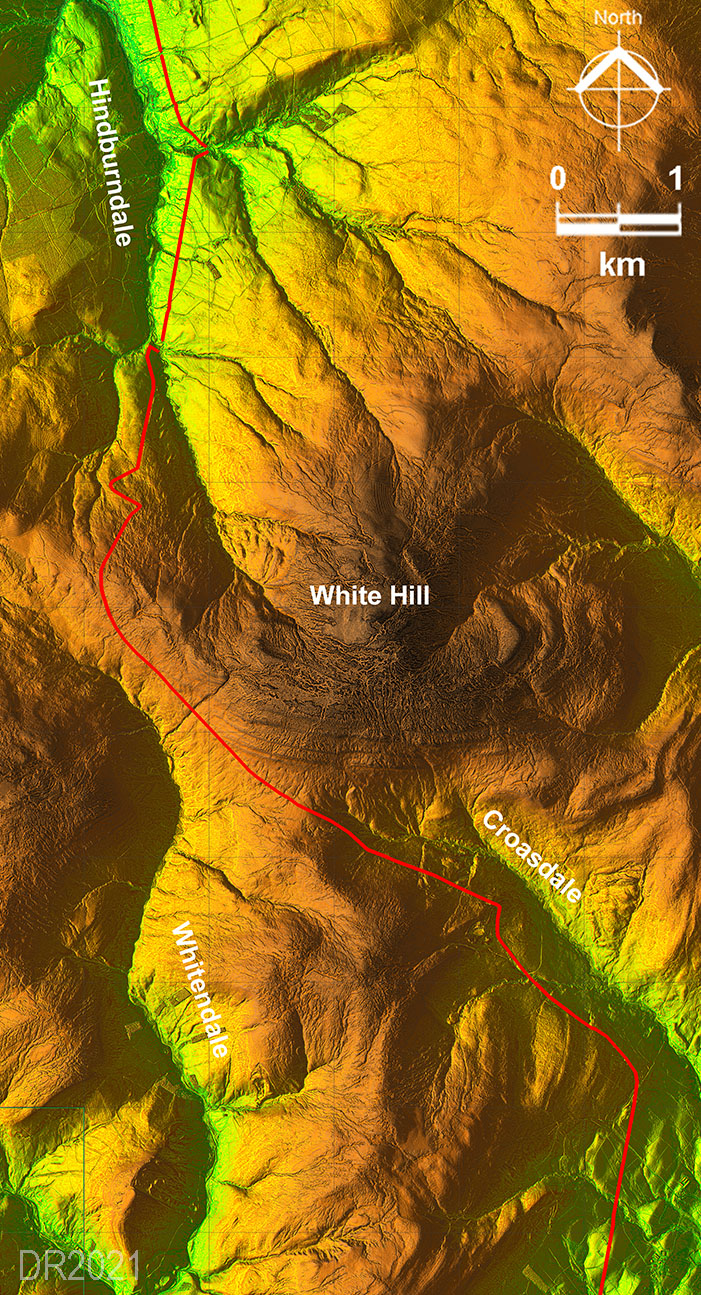
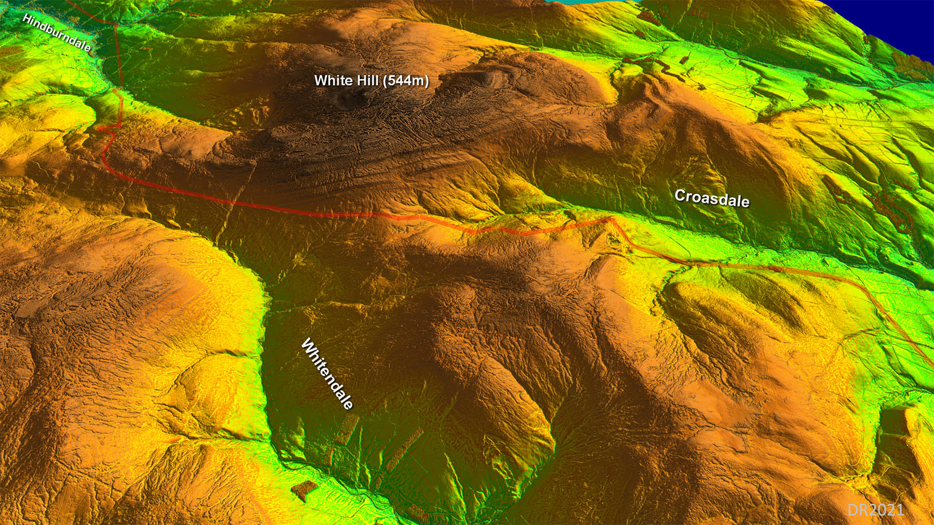
The Roman Road from Ribchester to Burrow in LonsdaleMargary Number: 7cDistance: 30 miles (using link road to Burrow fort)Continuation northwards of probably the original Roman military route from Manchester. The distance of just under 30 miles is exceptional for a days march especially given the severity of the terrain encountered reaching a height of 1400 feet on the Croasdale Crossing. You would have expected an intermediate fort or fortlet but so far I have not found one! NEW: Series 2 Lidar reveals some surprises on the road over the Croasdale Fells |
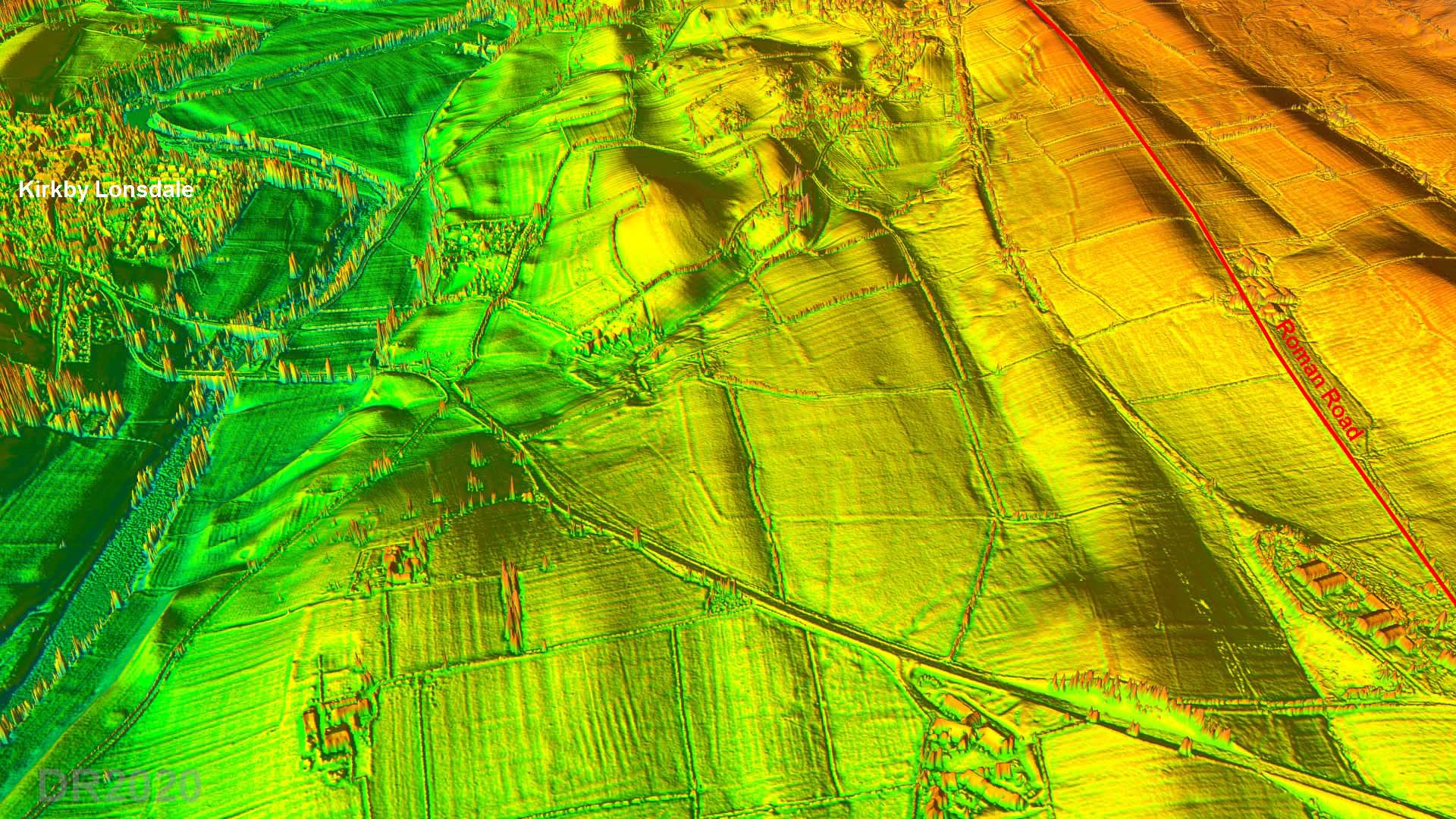
Historic County: Lancashire & West Riding of Yorkshire Current Counties: Lancashire & North Yorkshire HER: Lancashire & North Yorkshire
|
|
|
|
|
|
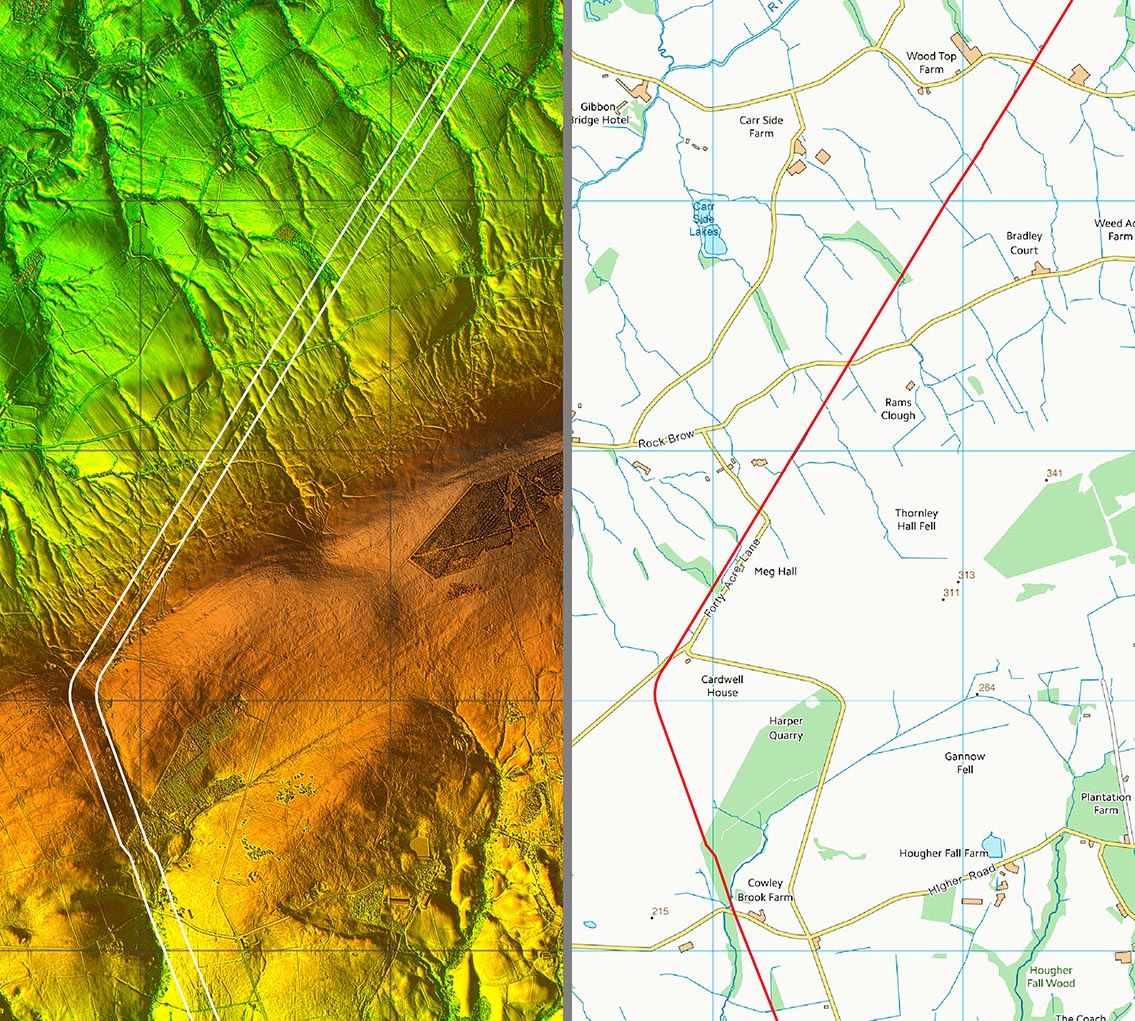
Lidar Image - Ribchester to Burrow They were not frightened of hills were they! You would have thought they would have gone via the Hodder gorge at Whitewell to Dunsop Bridge but no they went over Browsholme Heights. The Hodder gorge would not have been easy to get through and was perhaps more vulnerable to an attack. The route over Croasdale was probably a pre-Roman route that the Romans knew and decided that was the way to go.. The alignment passes 1 mile to the east of Burrow Fort and clearly gettiung to the north was the more important. The fort is reached a link road. |
Click for larger view |
 |
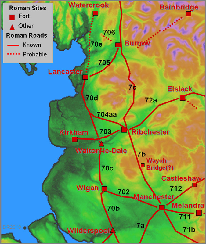
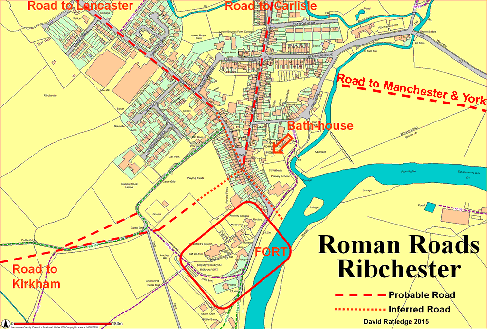
Ribchester Roman Road Map The original fort was further north than the later stone fort and the road layout was clearly designed/set out for the first fort. Our road, Margary 7c, heads out along Water Street and continues via Ribblesdale Road which in turn becomes the appropriately named Stoneygate Lane. |
Click for larger view |
 |
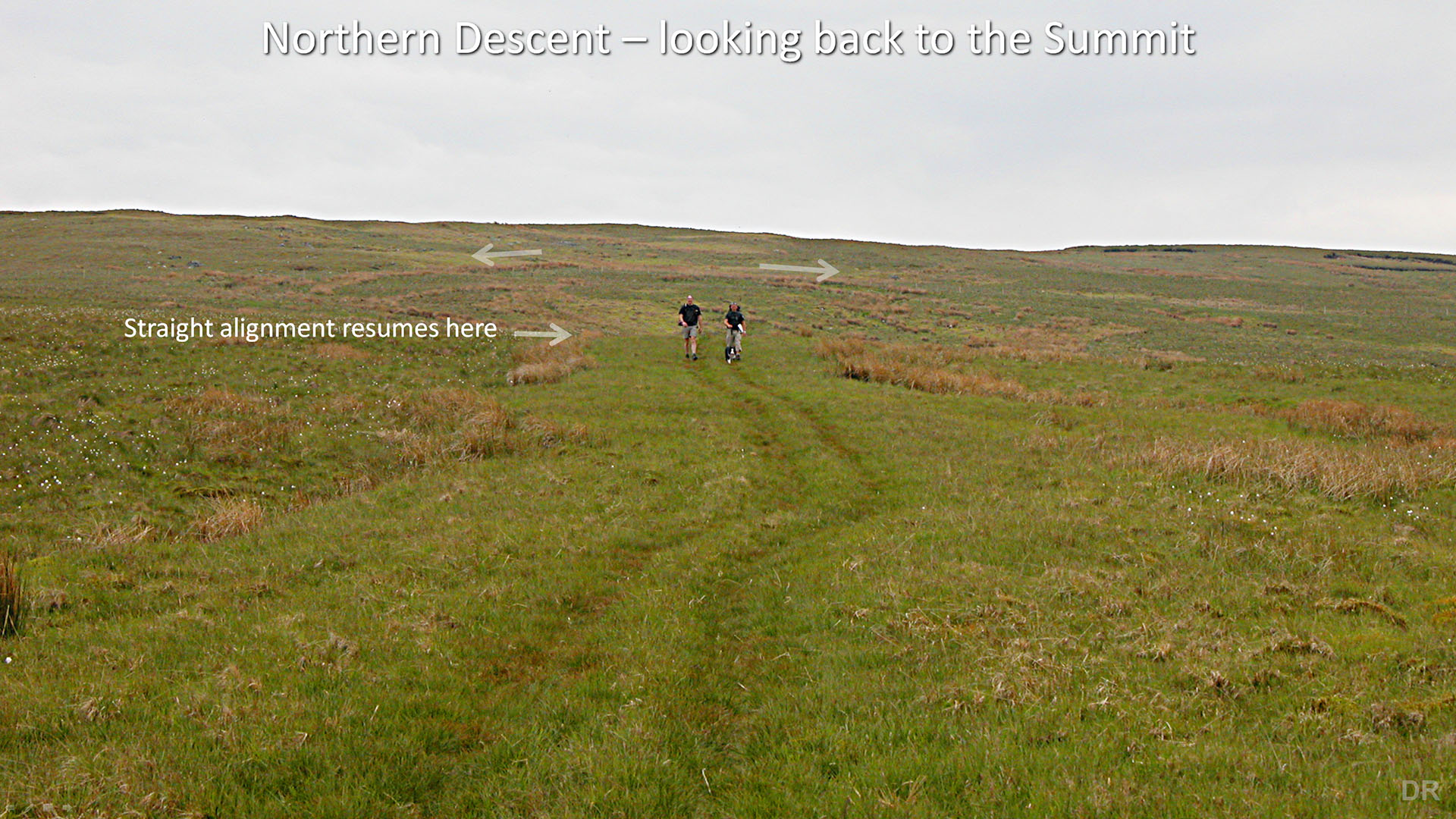
Lidar Image and Routemap 1 Get back on the Alignment must have been the instruction - only then will it head for Jeffrey Hill. Note: modern OS maps incorrectly show the road passing into the field behind Cherry Yate directly onto the alignment. This is incorrect. An inspection on site and the Lidar data shows no evidence for that. The modern road marks its true course. The OS route would have a nonsensical drop in level and subsequent needless climb back up again. No they were smarter engineers than that. |
Click for larger view |
 |
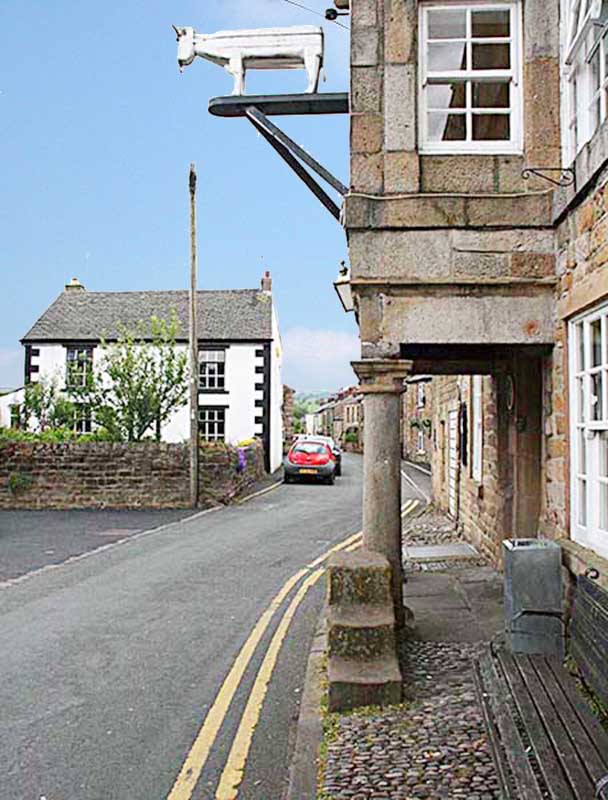
Water Street, Ribchester The original fort's east gate is behind us here and our road heads up Water Street passing the White Bull and its probable Roman columns. There are actually 4 columns - two either side of the entrance. The Bath House is to the rear of the pub so this site would have been an excellent one for a pub in Roman times too! |
Click for larger view |
 |
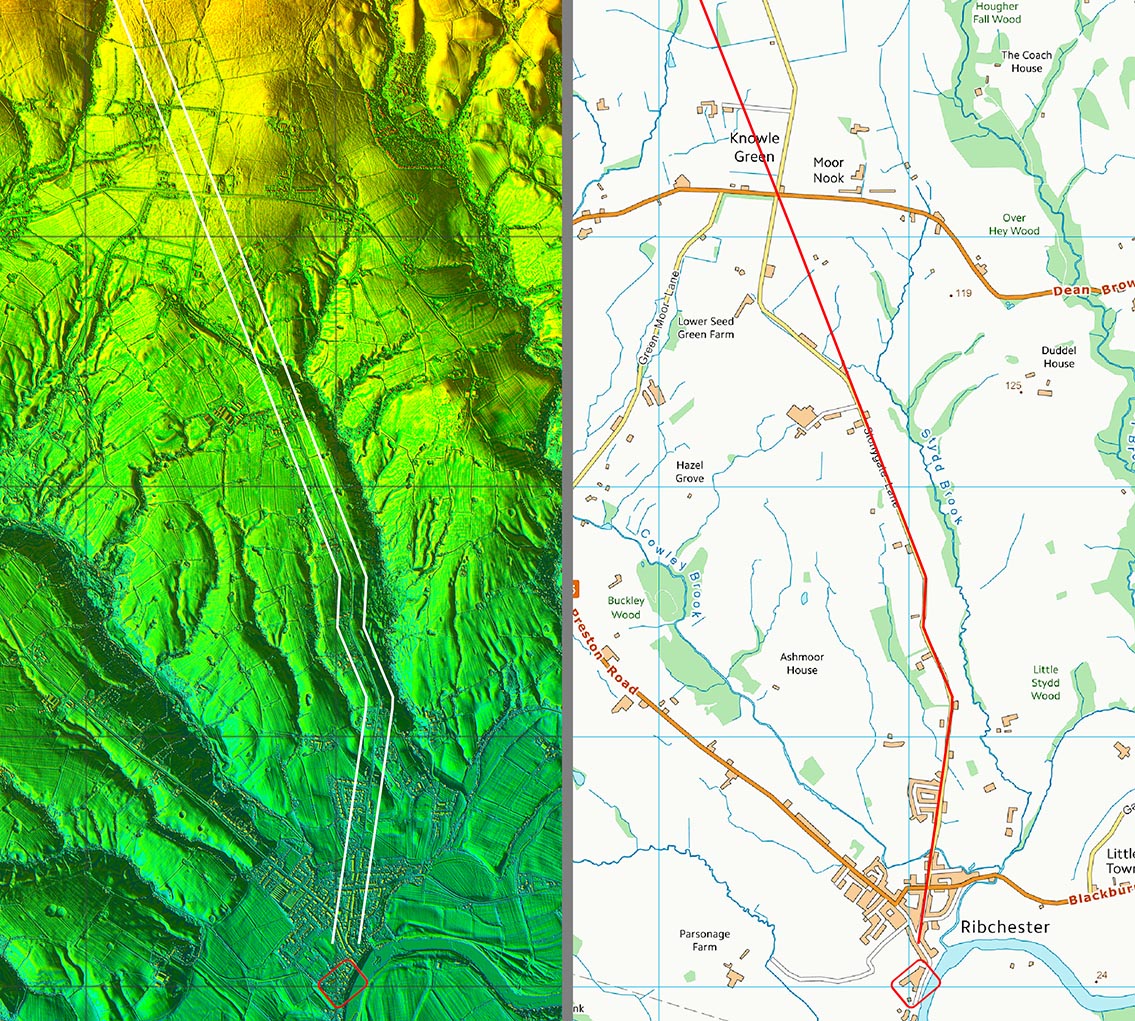
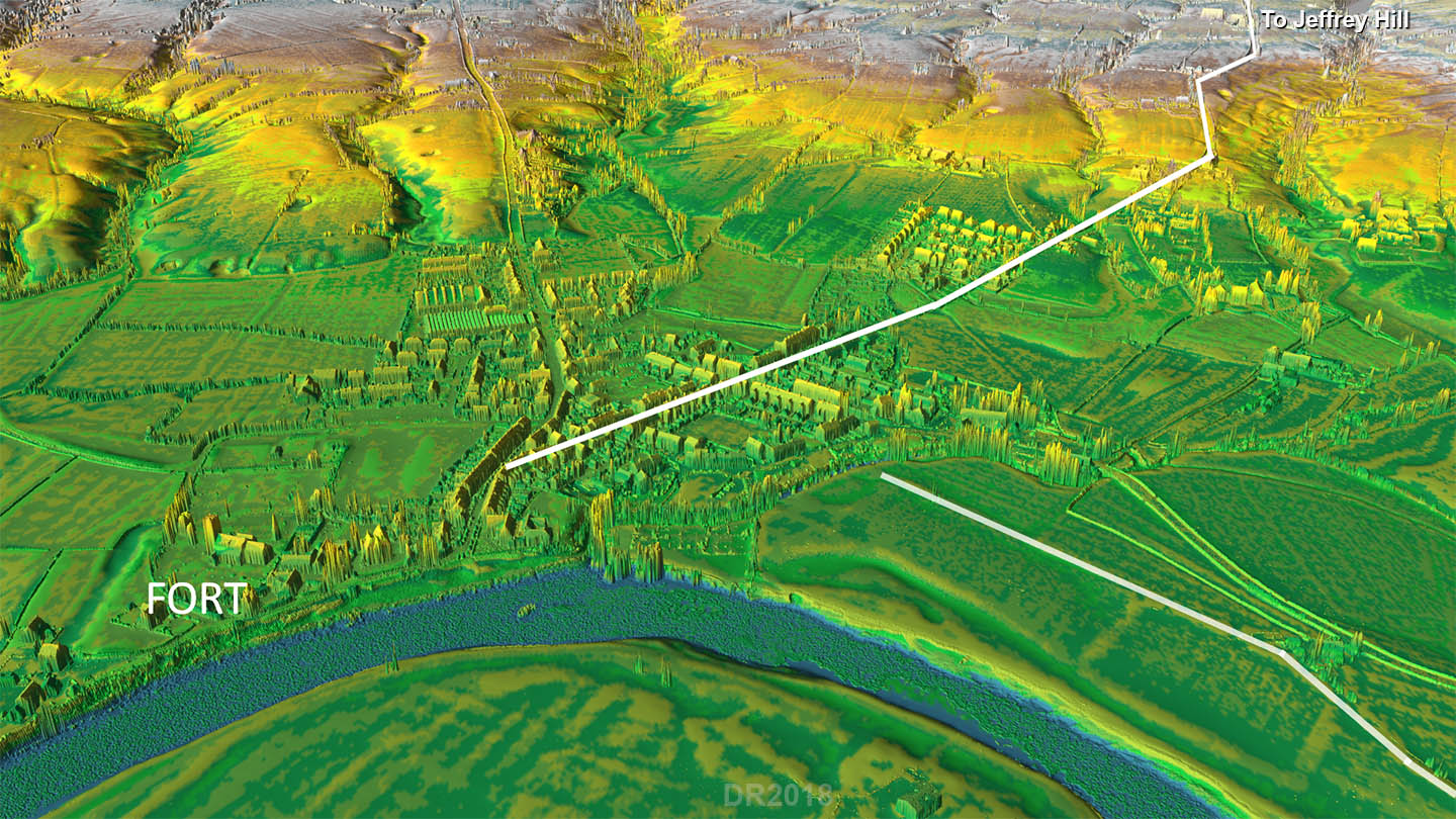
3D Oblique Lidar Image - Regaining the Alignment The direction of the road from Ribchester is not on Jeffrey Hill but angles to regain the setting-out alignment from Top of Ramsgreave to Jeffrey Hill. This is normal Roman practice. At Cherry Yate, originally Chester Gate, the road angles parallel to the above alignment but has to dogleg again a short distance further north to regain the actual alignment.
|
Click for larger view
|
 |
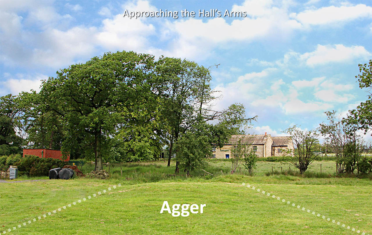
Approaching the Hall's Arms The Roman agger is clearly visible in the fields south of the former inn.
|
Click for larger view |
 |
Lidar Image and Routemap 2 The route chose to approach Longridge Fell via a little valley at Jeffrey Hill - quite clever really. This is where the road turns through 52 degrees to head for a spot on Browsholme Heights. But surprise surprise, it was a big curve not a sharp angle as everyone, including the Ordnance Survey, had believed. |
Click for larger view |
 |
Jeffrey Hill - View North The panorama from Jeffrey Hill is one of the best views in Lancashire with the Bowland Fells centre stage. Even the Roman engineers baulked at going straight ahead and with a choice of North-West or North-East chose the latter. So the alignment swings 52 degrees to the NE and heads for Croasdale via Browsholme Heights.
|
Click for larger view |
 |
Aerial Map - Croasdale Route The course they chose at first seems an odd one. A route via Dunsop Bridge and Whitendale is more direct and surely within their capabilities. But no they headed towards Slaidburn and the Salt or Hornby Road which crosses the Bowland Fells via Croasdale and Salter Fell. The only explanation I can envisage is that the Salt Road was already there when they arrived and they took the pragmatic solution to make use of it and upgrade just the length they needed. The Salt or Hornby Road was possibly therefore an Iron Age pre-Roman route for salt from Morecambe Bay to East Lancashire and Yorkshire. There are several Salter names along it perhaps supporting this theory. |
Click for larger view |
 |
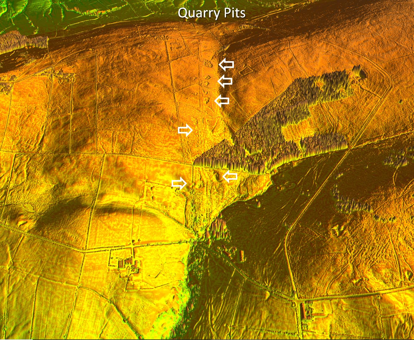
Quarry Pits on the ascent to Jeffrey Hill - Lidar Image Why transport stone for road building many miles if you can dig it out from alongside the road? That is exactly what they did and on the approach to Jeffrey are many quarry pits alongside the road. Notice also the slight dog-leg in the road just before the trees. |
Click for larger view |
 |
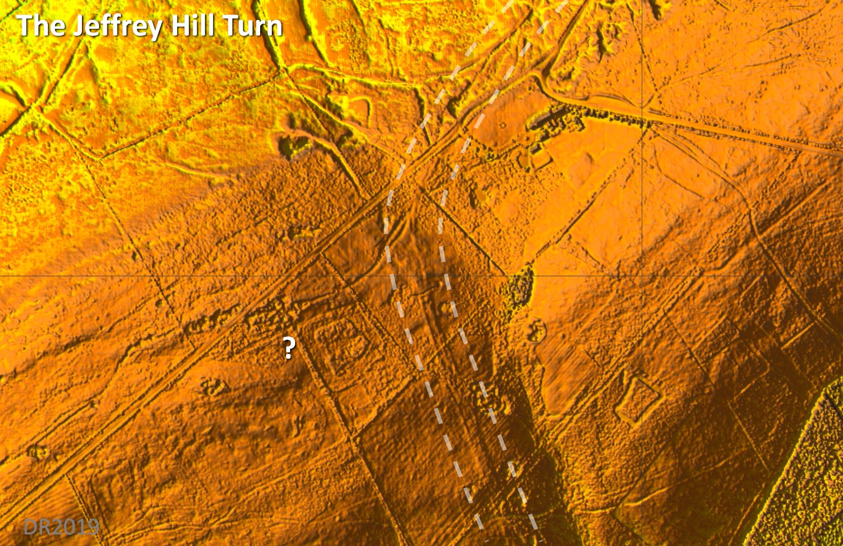
The Jeffrey Hill Turn - Lidar Image The curve is clear in the Lidar - it was not a sharp bend. Note: The new Lidar coverage has enabled the precise angle the road turned through to be measured. But because there was a little dogleg approaching Jeffrey Hill it can be measured as either 51or 52 degrees. It has been suggested that this is a "special" angle for the Romans but in reality the new direction is the optimum to get to Browsholme Heights - their next setting out point. |
Click for larger view |
 |
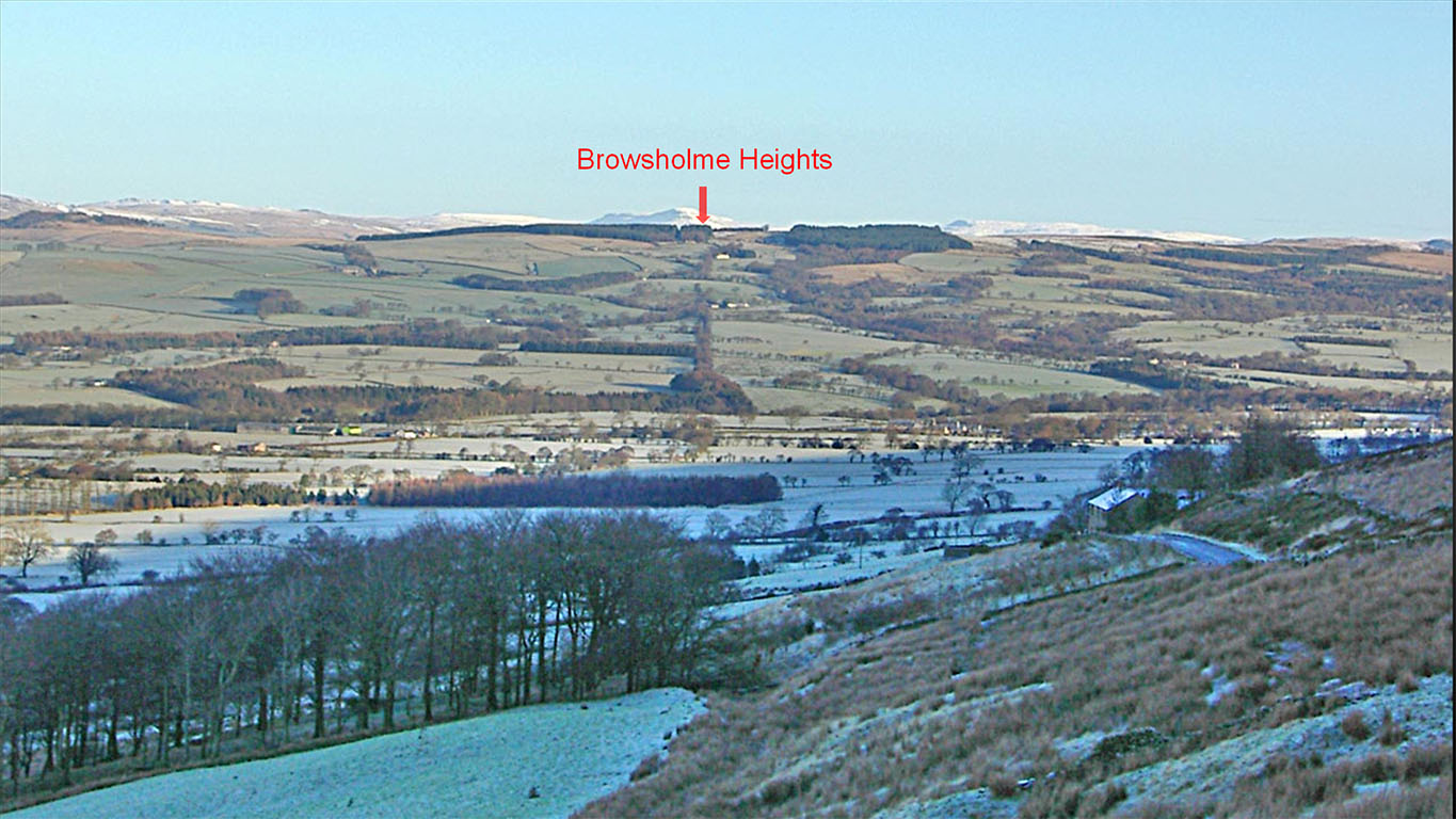
Jeffrey Hill to Browsholme heights Alignment The Roman road can be seen angling across the steep slope of Jeffrey Hill just below, and parallel to, the present road and marked by hedgerows in the distance. This section was aligned on Browsholme Heights although it is often claimed it is aligned on the the summit of Penygent, visible in the far distance on very clear days. Our photo indicates not on Penygent but it demonstrates how Roman engineers did use high points (Browsholme Heights) to set out their roads. |
Click for larger view |
 |
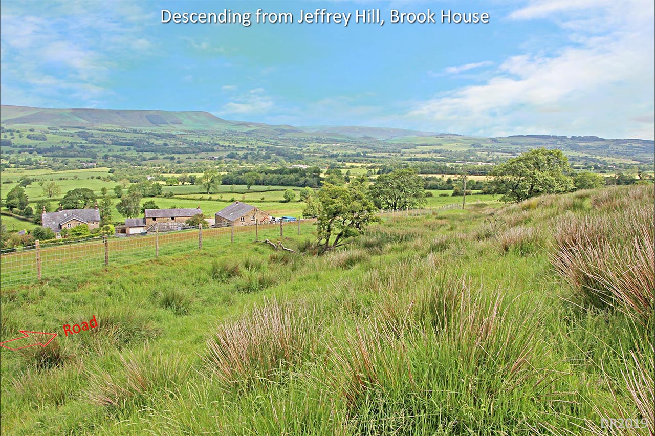
Descending from Jeffrey Hill It is amazing how they got off such a high hill with a consistent gradient that is no way as steep as you would imagine. The gradient averages at 1 in 10. Water action has deepened the road ditches to such an extent that although the course of the road is obvious it no longer has a classical cross section. |
Click for larger view |
 |
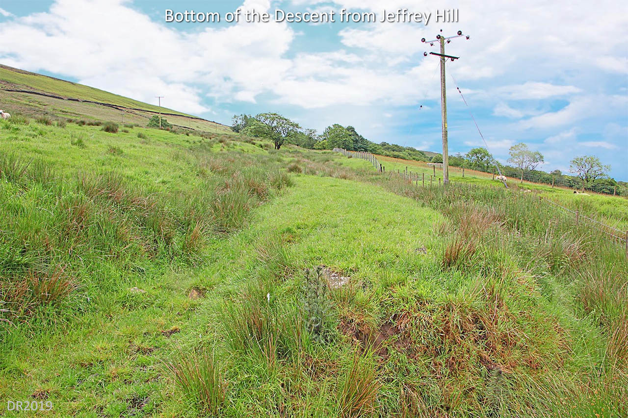
Bottom of the descent from Jeffrey Hill This at the bottom of the descent looking up back to Jeffrey Hill. Sure it would have been hard work climbing up the gradient of 1 in 10 but not impossibly so. |
Click for larger view |
 |
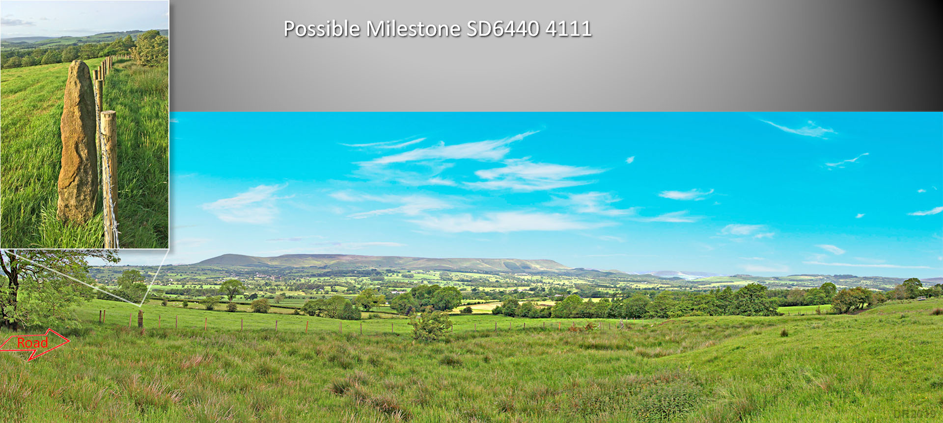
Possible Milestone, Thornley-with-Wheatley Beyond the bottom of the descent from Jeffrey Hill is a possible milestone alongside the road. It has clearly been reused as a gatepost but its location as a single stone alongside a spectacular length of road perhaps indicates it could have been a Roman milestone. Today it is much weathered as is the road here which has been severely damaged by water action over the centuries. Thanks are due to Ian Milnes for bringing this to my attention and arranging access to what is a private location. Ian also took the close up inset photo of the stone in evening sunshine. |
Click for larger view |
 |
Lidar Image and Routemap 3 The Hodder has to be crossed twice. The first would surely have required quite a substantial bridge - see below for how they negotiated this obstacle. The alignment is still carrying straight on for Browsholme Heights. |
Click for larger view |
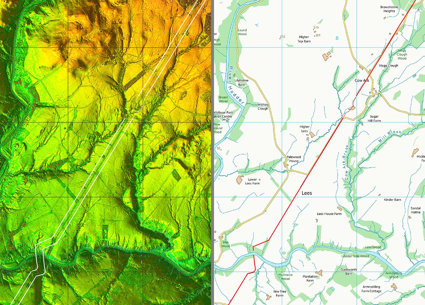 |
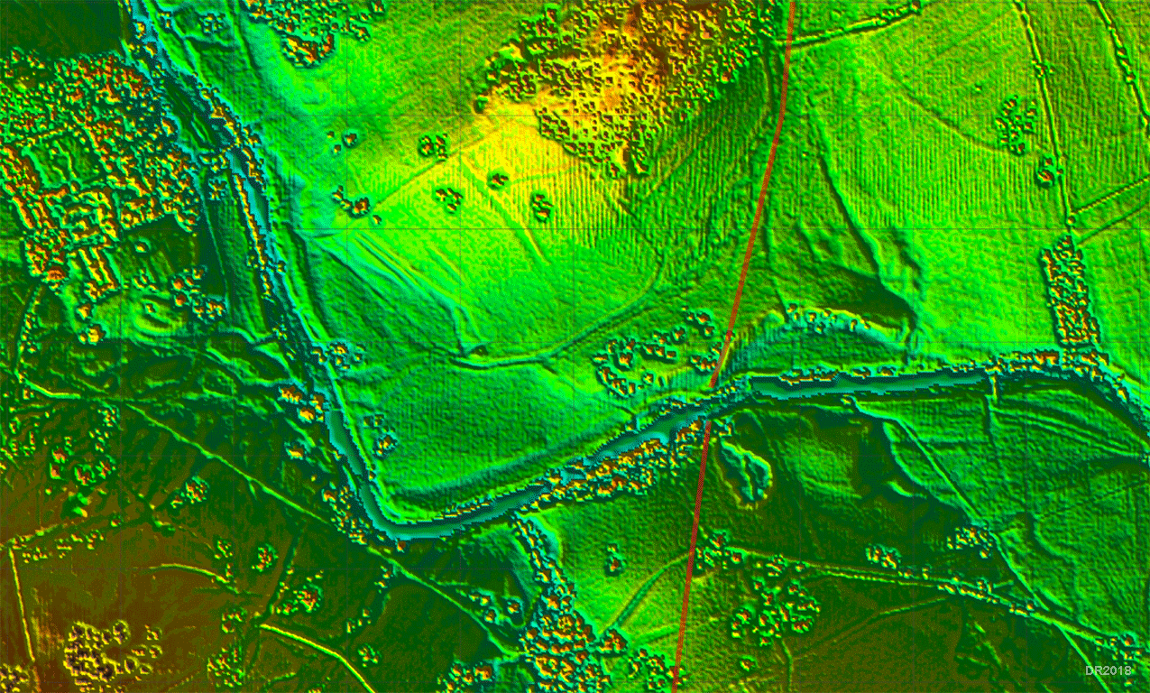
Lidar Image and Route Map - River Hodder Crossing 1 Having got off the fell, then the next major obstacle on this alignment was the (first) crossing of the Hodder - this was the old Lancashire-Yorkshire boundary until 1974. Following the construction of a pipeline, the zigzag ascent north of the river was spotted by Peter Iles. Taken with the zig-zag on the southern descent this demonstrates very clever engineering to get down to what must have been the best crossing point. Note the Ordnance Survey line just carries straight on across the river and, as we now now know, incorrectly.
|
Click for larger view |
 |
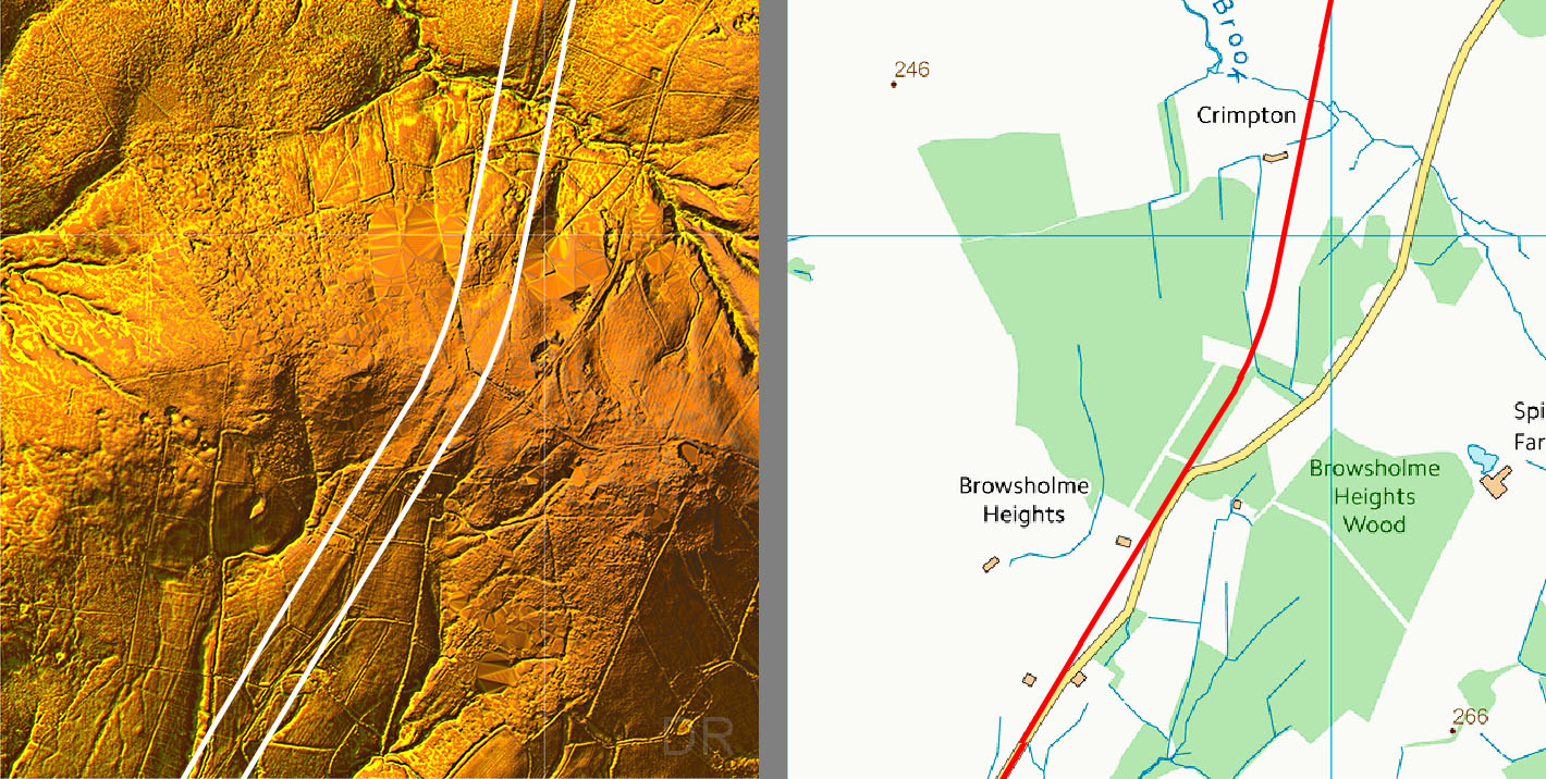
Lidar Image and Routemap 4 At Browsholme Heights the road swung more northerly aimed at Low Fell at the start of the Croasdale Valley. This change of direction near Marl Hill had been questioned by Ben Edwards, the former County Archaeologist - the modern road route he thought more logical. The gap in the route shown in the centre of this map is where a landslip has occurred removing all traces of the road. |
Click for larger view |
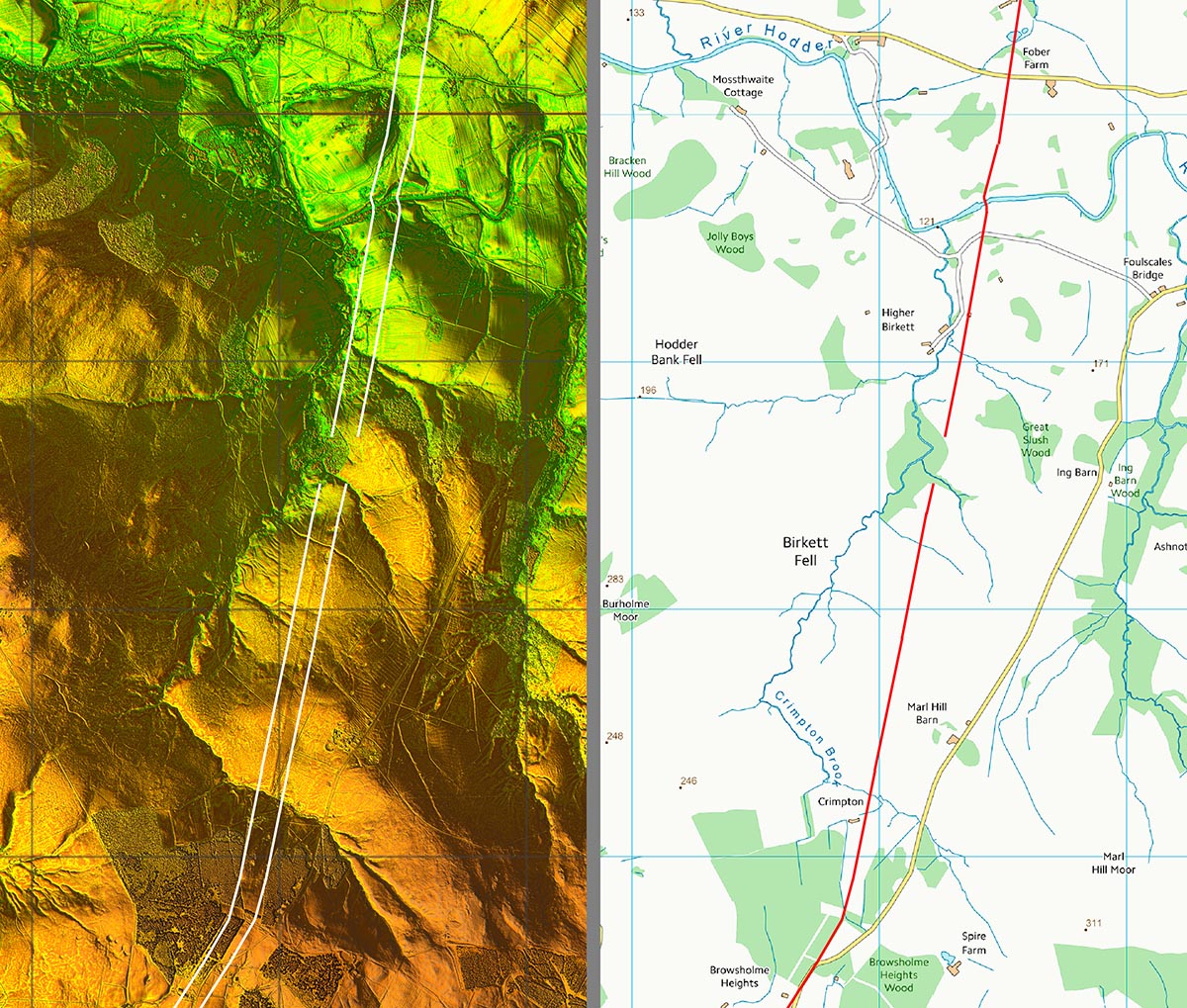 |
Browsholme Heights - Change of Direction Again it was not a sharp angle but a gradual curving turn. The surveyor for this road liked his curves. All three summits - Jeffrey Hill, Browsholme and Croasdale - employed curves. . |
Click for larger view |
 |
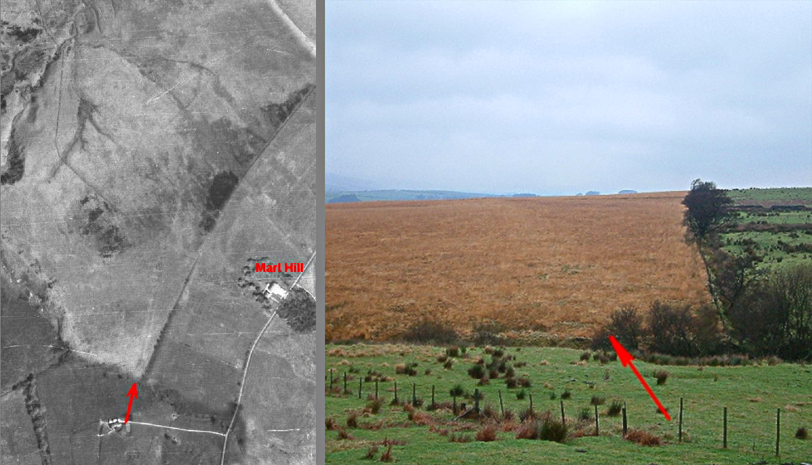
Aerial Photo (c.1947) and Ground level View - Marl Hill This was the scanned 1947 aerial photo that confirmed the road did indeed change direction here just as the OS First Edition surveyors recorded. The ground level view by Peter Iles confirms this too with the large agger showing as slightly lighter coloured grass. The two red arrows are roughly in the same spot. . |
Click for larger view |
 |
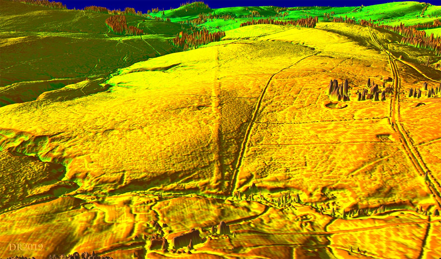
Oblique 3D Lidar view - Marl Hill How could it ever have been in doubt? The release of new Lidar data in 2019 revealed the huge agger of the road heading north at Marl Hill. . |
Click for larger view |
 |
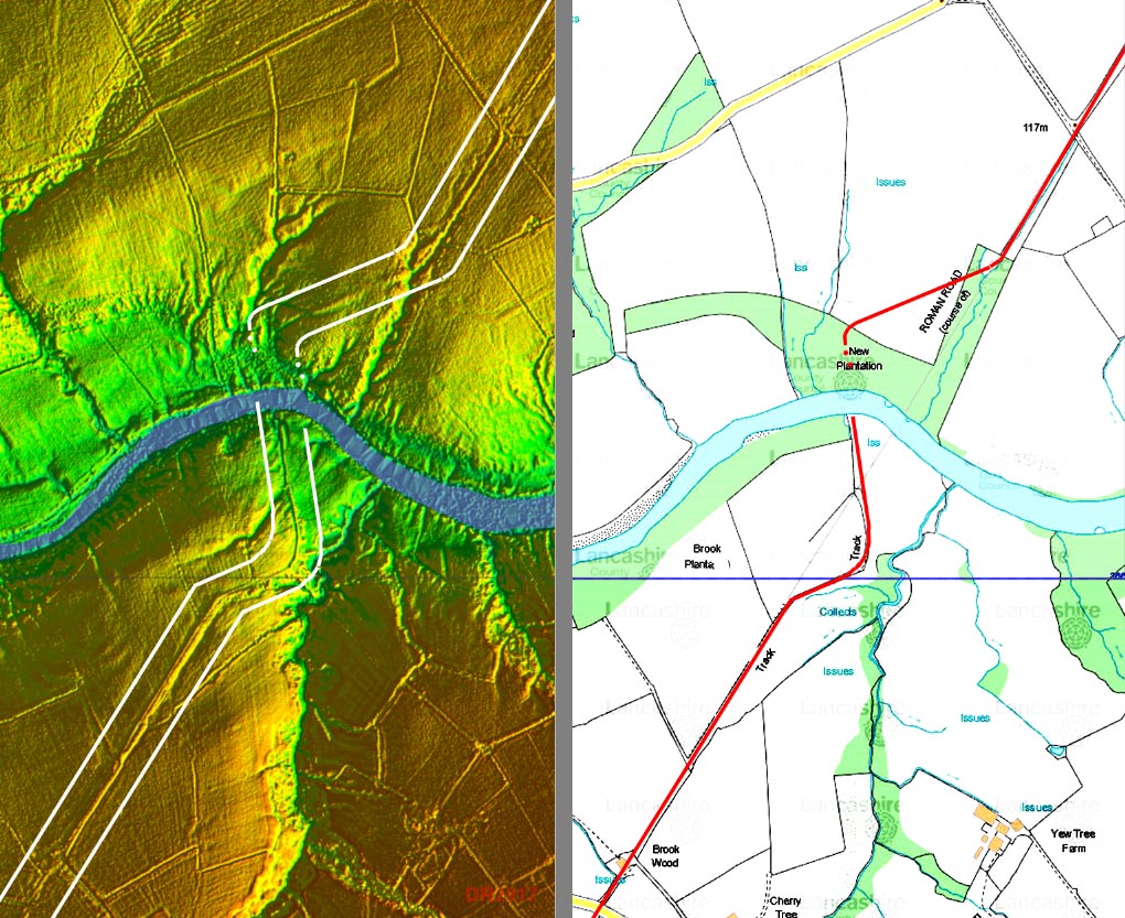
3D Oblique Lidar Image - River Hodder Crossing 2 The alignment change at Browsholme Heights is also supported by Lidar, which shows the Roman road heading for second crossing of the Hodder at an ideal fording or bridging point - just where there is a natural limestone outcrop. |
Click for larger view |
 |
Lidar Image & c.1947 Aerial Photo - River Hodder Crossing 2 This second crossing of the Hodder would have been a very logical position for an intermediate fort. The c.1947 aerial photographs actually appeared to show just that! However, site visits and Lidar data shows it was a false supposition. The image (right) is an animated gif and alternates between the Lidar image and that 1947 aerial photo. |
Click for larger view |
 |
NEW 2020 - 3D Lidar video flyover across Jeffrey Hill
|
||
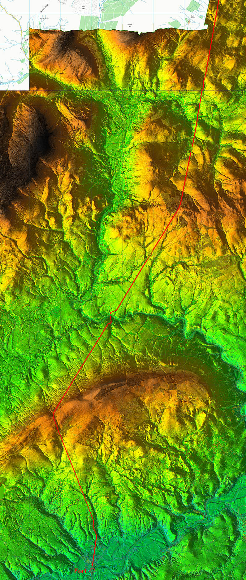
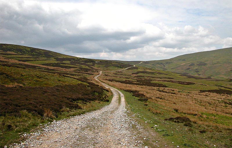
Start of the climb up the Croasdale Valley The start of the route the Roman engineers chose through the Bowland Fells was via Croasdale. Part of the track is now known as the Hornby Road (or Broken Bank Head). The most logical explanation of the route selected as we have seen is that it probably made use of a pre-Roman salt route across the fells - the Romans simply adopted and upgraded it. It must have been a daunting journey in bad weather. The ascent to the pass was adapted to the contours. Alongside the road are several borrow pits - i.e. quarry pits where the Roman quarried for road stone. No point carrying materials miles when it was available next the road. For more details and images of walking the the spectacular Croasdale section of the Road - click here. It is a walk every Roman road enthusiast should undertake at least once! Image: DR |
Click for larger view
|
 |
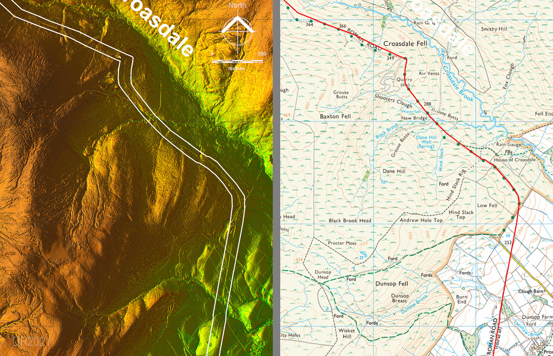
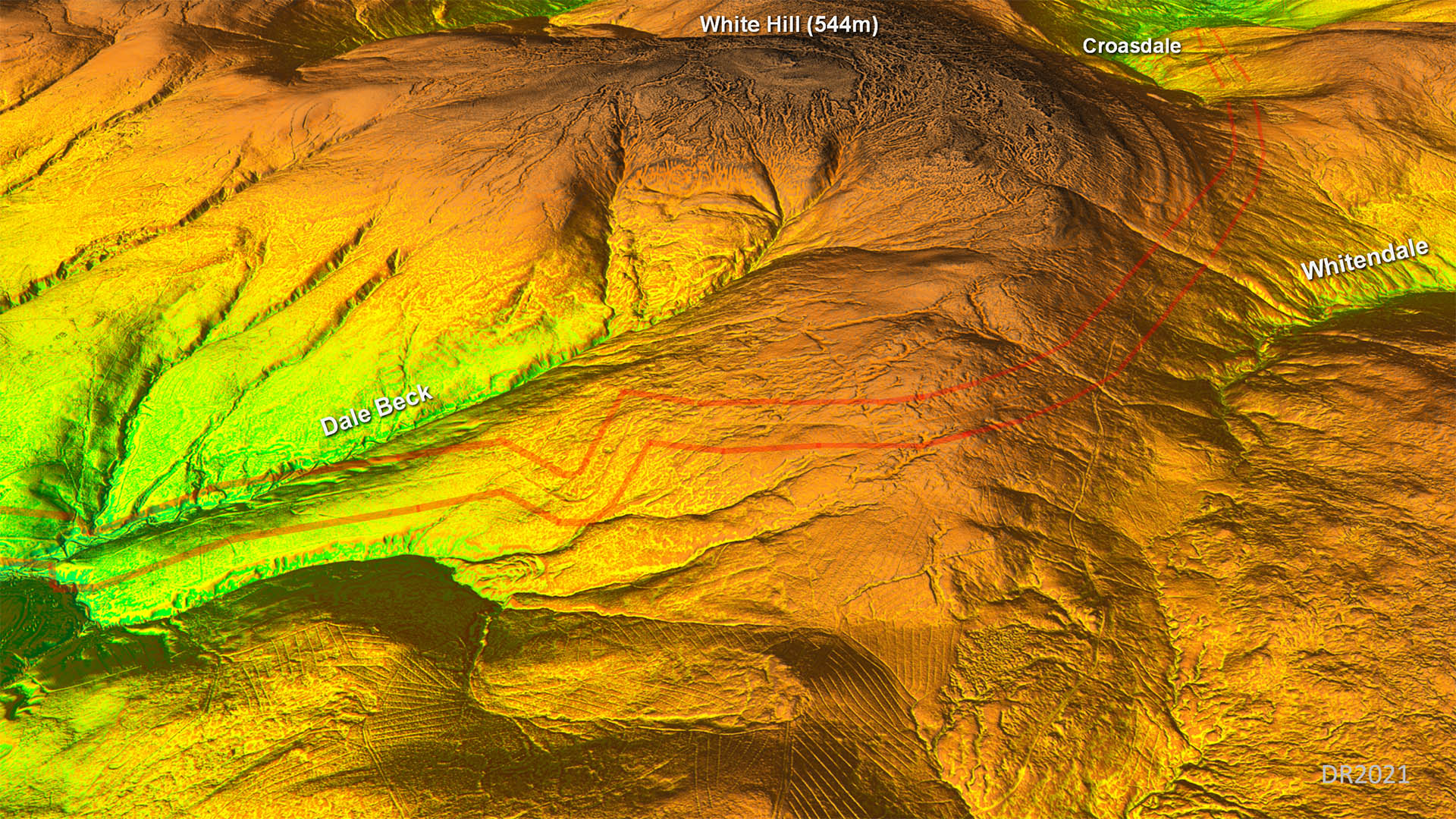
Lidar Route Map over Croasdale At long last we have lidar data for Croasdale and it has revealed several surprises! The OS route is wrong in several place on the southern ascent and we all missed that huge zig-zag on the northern descent. Details below: . |
Click for larger view |
 |
Oblique Lidar Image of the route over Croasdale This a 3D view of the plan shown above. The climb from the south is long and very gradual and easy but the same cannot be said for the journey north to south. The climb up from the Hindburn valley is short and steep with, as we now know, two dog-legs. The higher of which was unknown and is huge. . |
Click for larger view |
 |
Lidar Image and Route Map 1 over Croasdale I was hoping to spot a fortlet here as an intermediate station between Ribchester and Burrow This first stretch of the road served a modern quarry and the bridge is obviously modern too. However, there are places where the modern road diverges from the original Roman alignment at:- SD69050 55653, SD68724 55887, SD67967 56772, SD67255 57076 & SD66565 57520.
|
Click for larger view |
 |
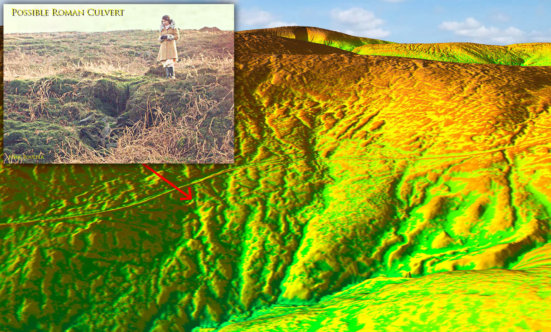
Roman Road and possible Culvert in upper Croasdale There are numerous stone culverts along the Hornby road but as some of these are on the modern track and not on the Roman alignment then they can only be modern. However, on one of the abandoned Roman alignments there is perhaps one genuine Roman culvert remaining.. The lady is standing on the Roman road running left to right with the culvert below her. Thanks to John Poulter for bringing this to my attention. Image: John Poulter
. |
Click for larger view |
 |
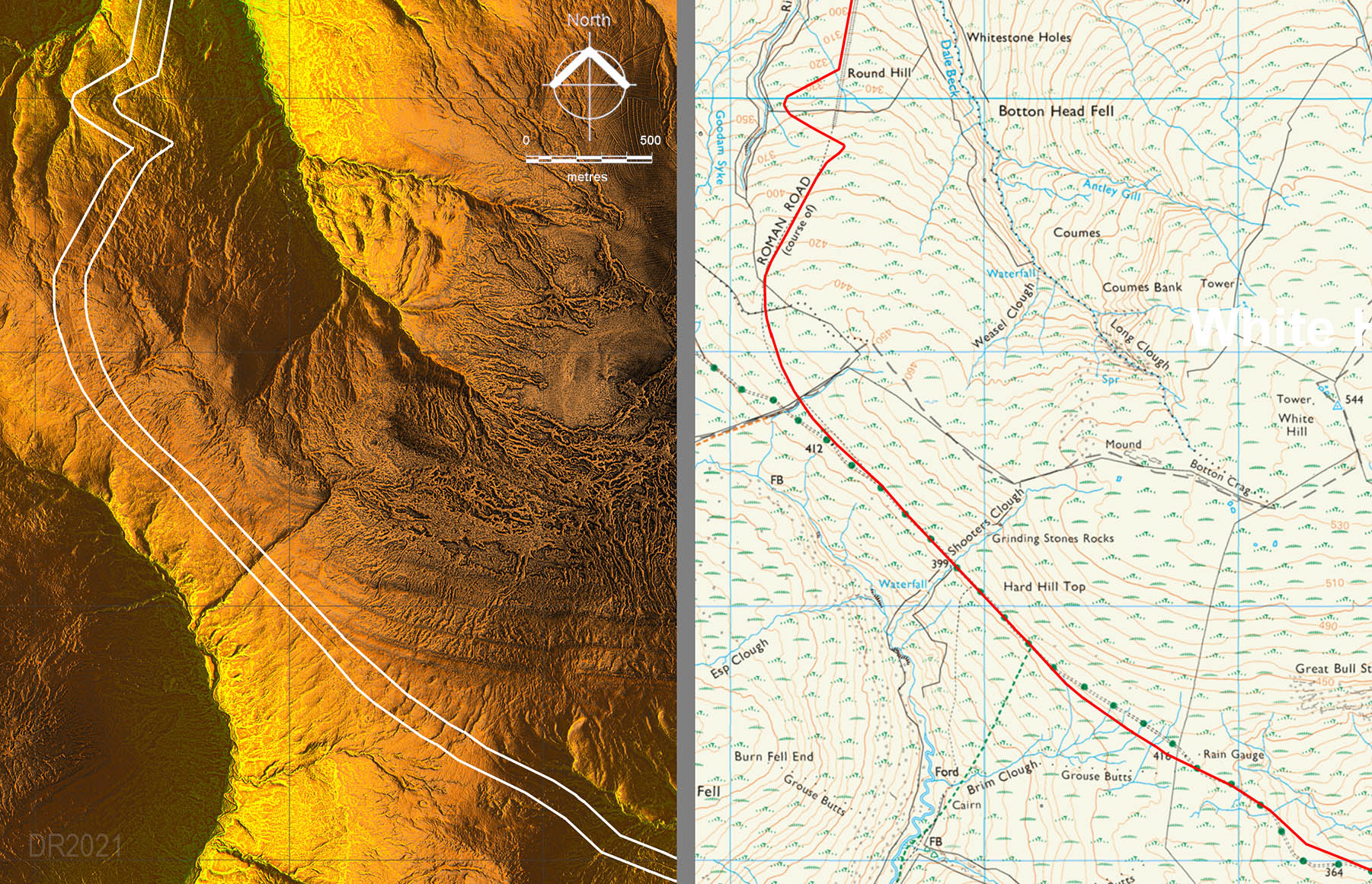
Lidar Image and Route Map 2 over Croasdale There are several sections where the Roman line straightlines the modern track. After the large curve at the summit (1420 feet) Lidar has revealed a huge double-zig-zag. How everyone (me included) missed this is amazing. In my defence the top there is now covered in peat hags and spotting the zig-zag is not easy. I did take a photo there and realised the line did not match the OS route but never understood what the explanation was. . |
Click for larger view |
 |
Summit Amazing the curve at the summit is terraced into the side of the hill. The Romans dug down about 3 metres to get a level platform for the road. The figure is stood on the side-slope of the Roman cutting. Image: DR . |
Click for larger view |
 |
Oblique Lidar Image - The New Zig-Zag 1 This view gives an indication of why the zig-zag was necessary. The descent actually steepens there so the gradient must have been too steep for Roman traffic. . |
Click for larger view |
 |
Oblique Lidar Image - The New Zig-Zag 2 How did we all miss it? I should have realised as I had noticed in one of my photos that the road was not strainght but did not guess it went so far off line.
. |
Click for larger view |
 |
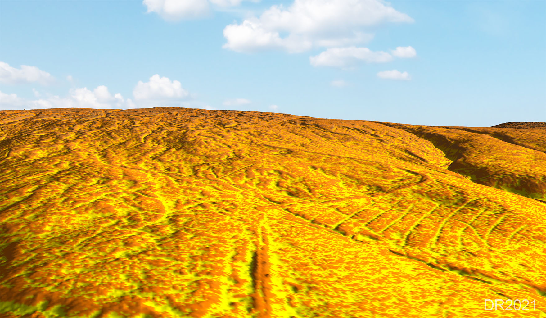
Lidar Image - close up of the upper zig-zag This closer view shows the zig-zag very clearly and indicates it is still in remarkable condition. Without the zig-zag the gradient would have been 1 in 6 and we have seen elsewhere this is generally regarded as too steep for Roman traffic. A maximum gradient of around 1 in 10 is what they generally seemed to have aimed for. . |
Click for larger view |
 |
On the ground image of the zig-zag This is a similar view to the lidar one above but obviously at ground level. I took this around 15 years ago and did notice the road did not appear to be where it should be but the penny did not drop as to what was going on. In hindsight there is no sign of the road behind the two walkers so it should have been obvious. .Image: DR |
Click for larger view |
 |
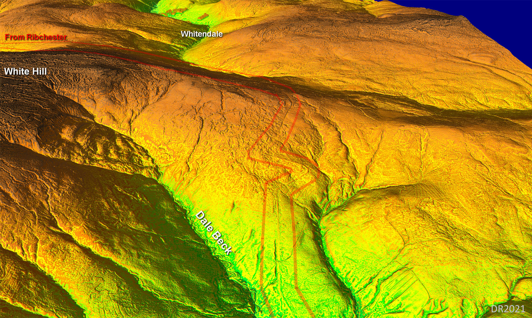
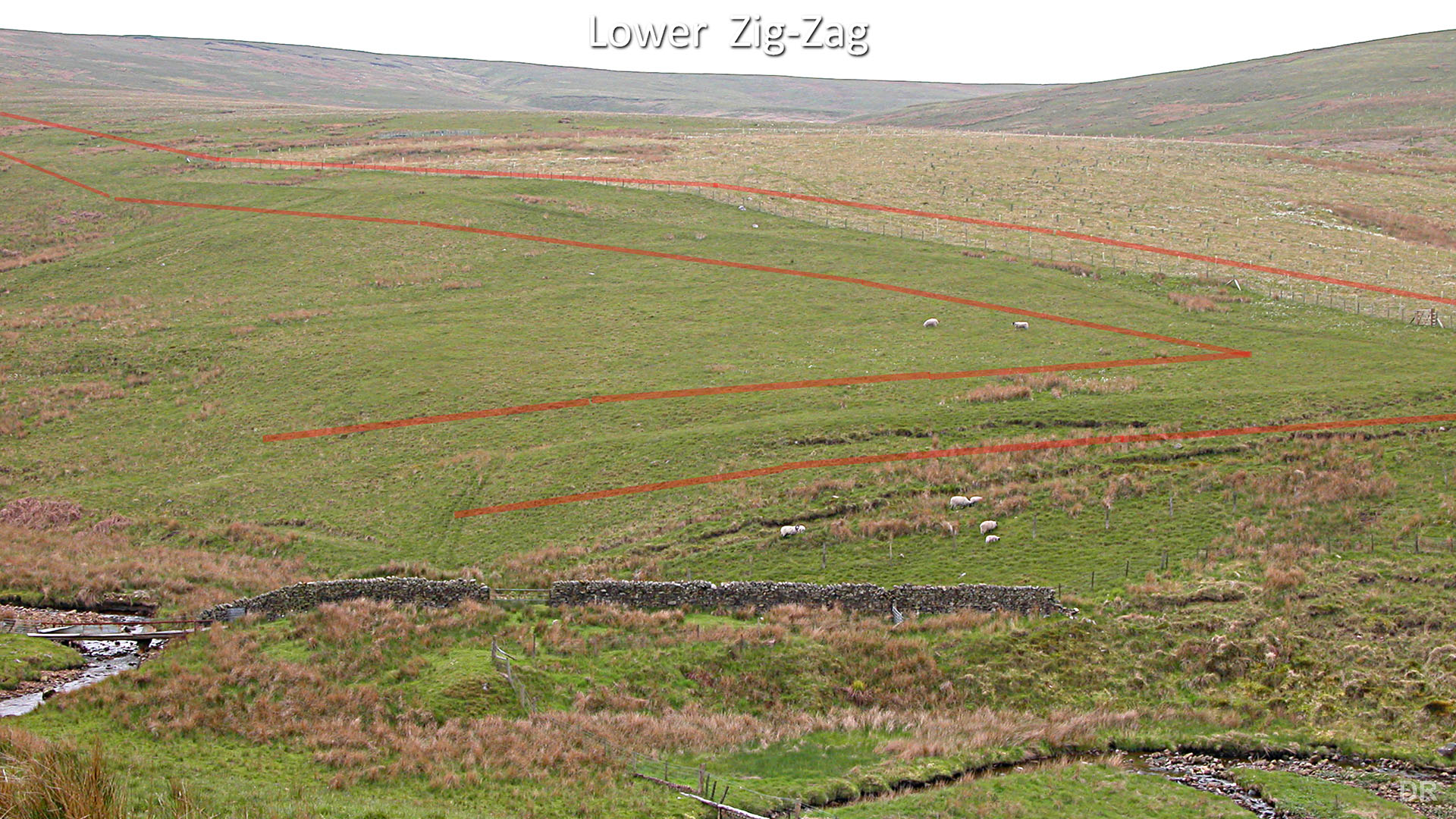
Lidar Image and Croasdale Route Map 3 - Northern descent The lower zig-zag is below the peat line and easy to spot (see photo below). . |
Click for larger view |
 |
Lower Zig-Zag Terrace, Dale Beck This is the lower zig-zag. The OS shows a straight line but the road zig-zagged to the west and the terraces are still obvious in this view across the beck looking back. This was known before (apart from the OS) but lidar has confirmed as definite. Is that hump by the beck the old bridge abutment? Image: DR . |
Click for larger view |
 |
Incline for Whiteray Beck Again the OS shows the road going straight on across the ravine of Whiteray Beck. It zig-zagged upstream and Peter Iles is stood on the incline down.. Image: DR . |
Click for larger view |
 |
NEW 2021 - 3D Lidar video over the Bowland Fells
|
||
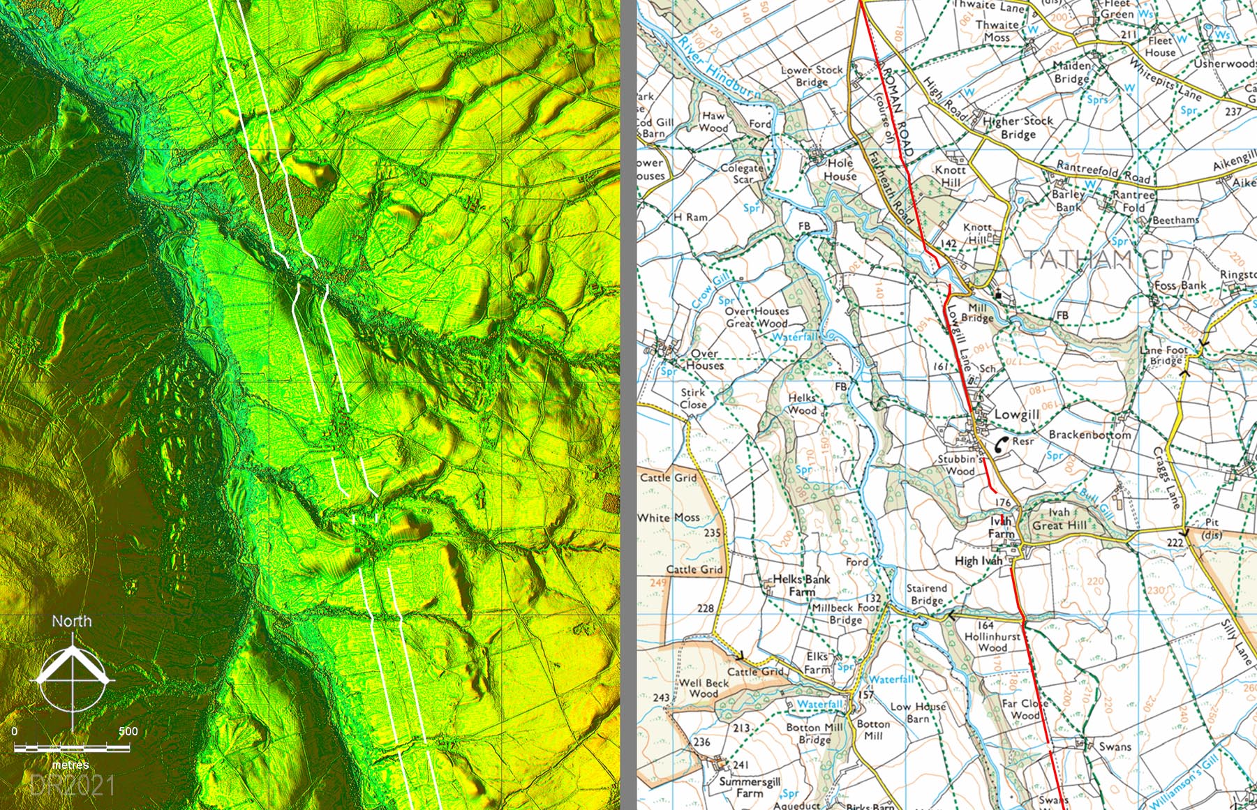
Lidar Image and Hindburn Valley Route Map The side valleys are the issue here and it is not totally obvious how the Romans dog-legged across them due to modern disturbance/buildings. . |
Click for larger view |
 |
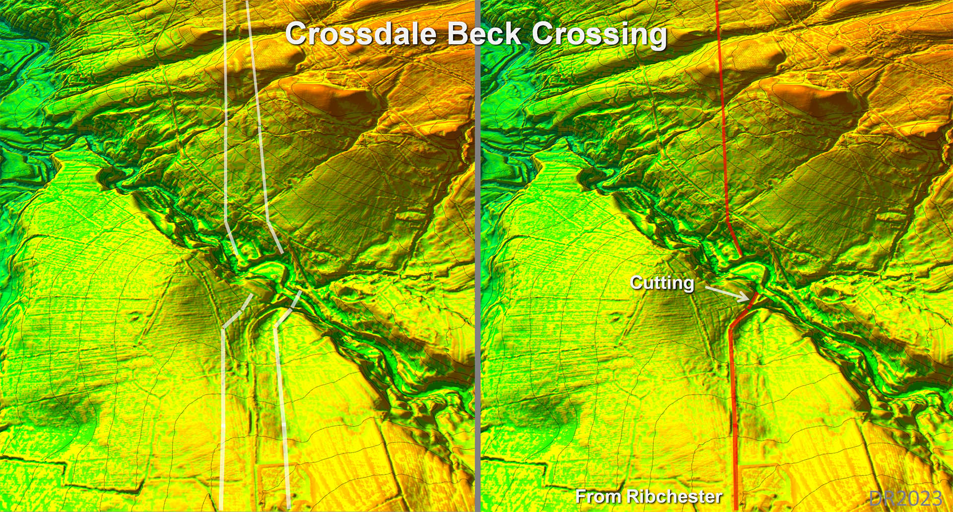
3D Lidar Image - Crossdale Beck Crossing, Hindburn Valley Map Another tricky ravine to cross but this time they seem to have decided to dig a cutting on the south side of Crossdale Beck and then used an angled terrace on the north side. . |
Click for larger view |
 |
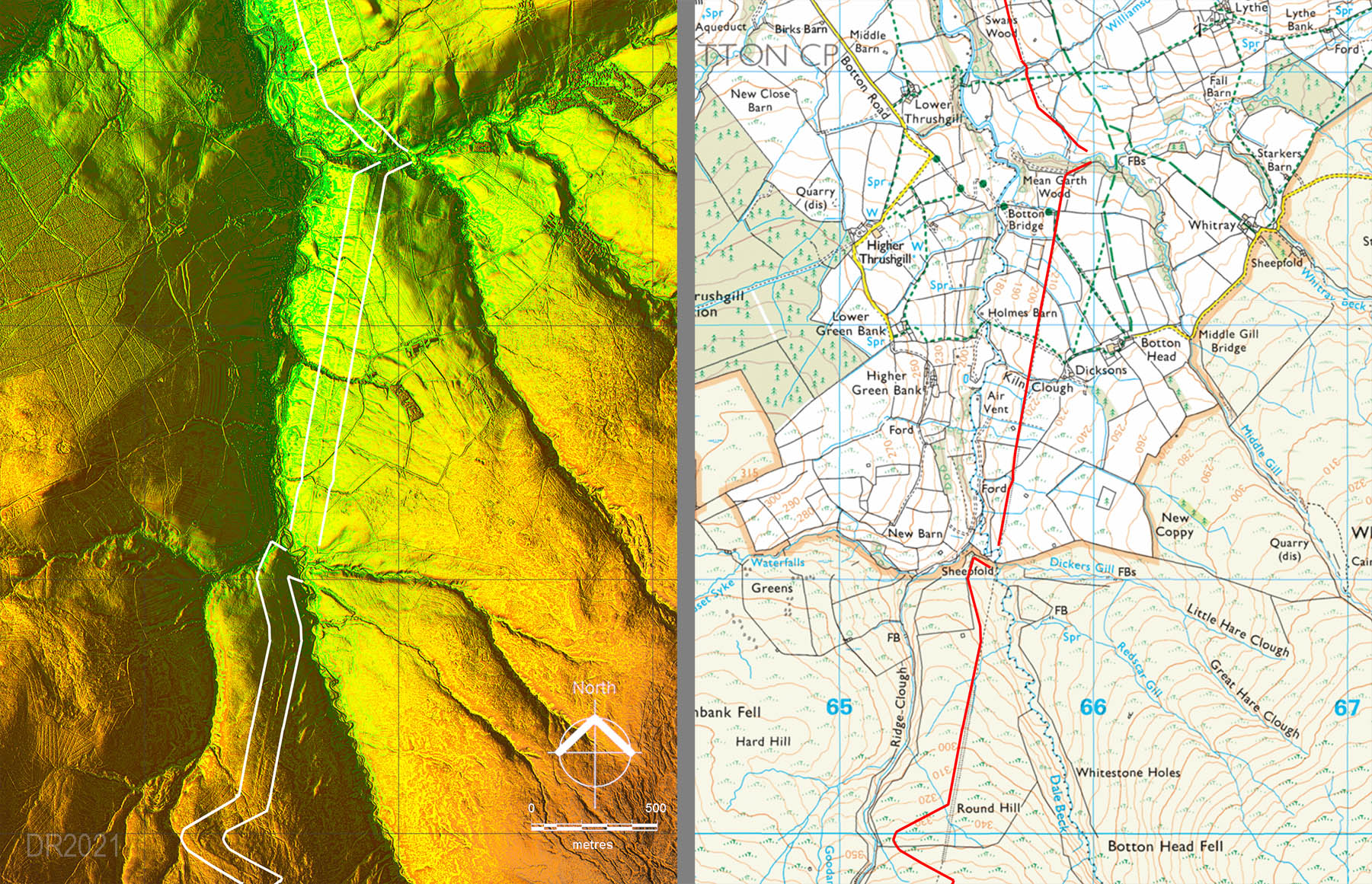
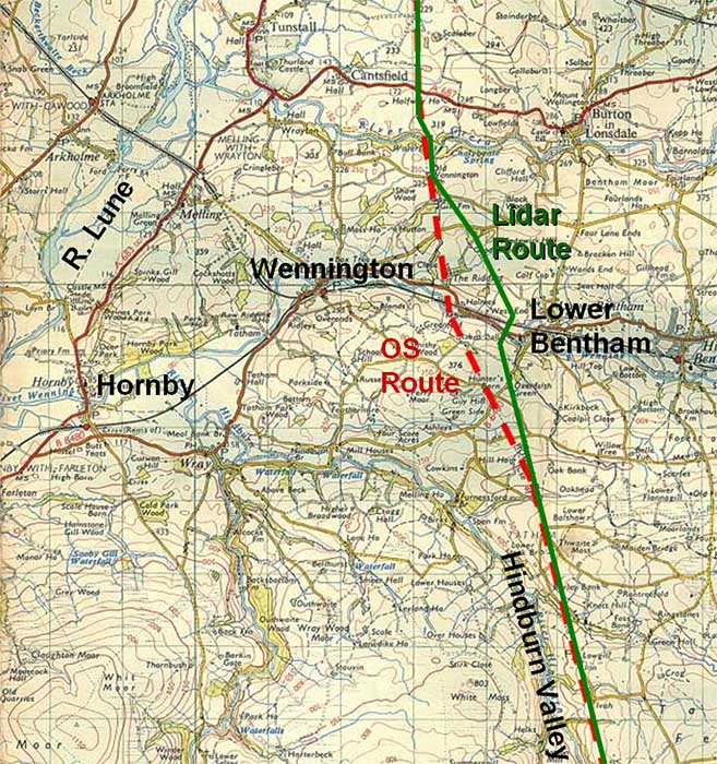
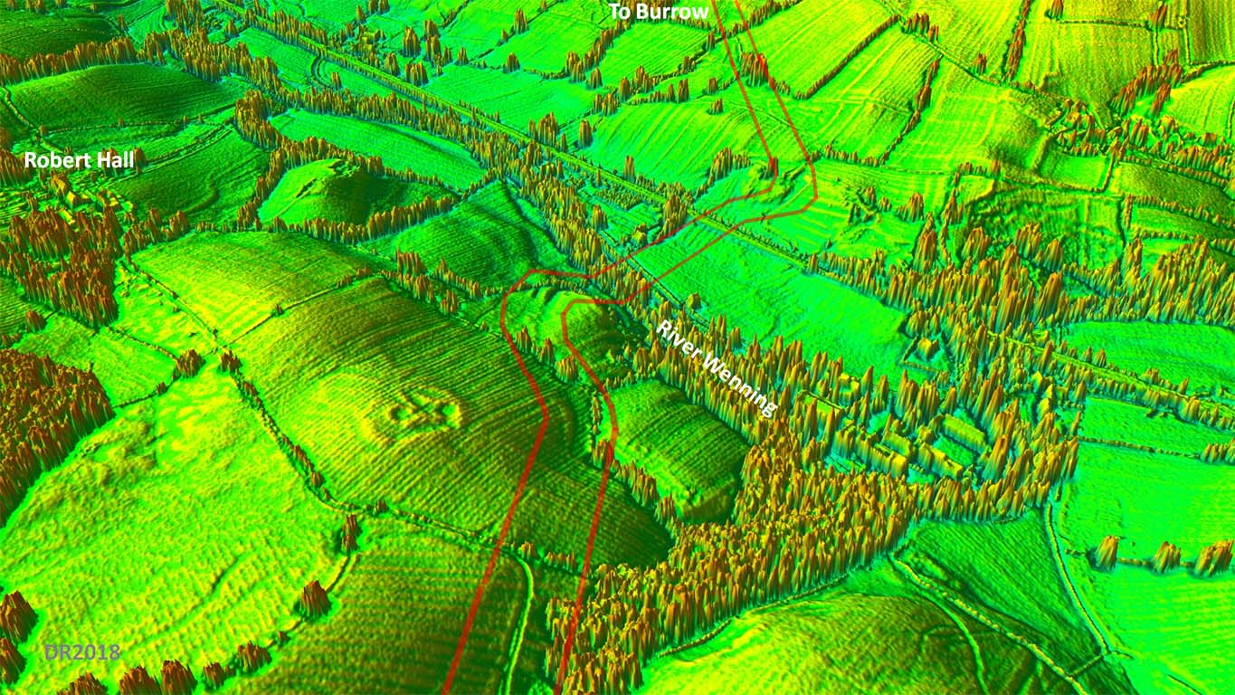
Route Map - OS and Corrected Route Recent Ordnance Survey maps have shown the road leaving the Hindburn valley and then taking a dogleg to the north-west under Robert Hall and following a course on or near to the county boundary between the River Wenning and River Greta. I had long been suspicious of this and it was one of the first routes I checked with Lidar. What Lidar showed is that there is nothing visible on the OS Robert Hall route but there is very clear evidence for the alignment from the Hindburn valley continuing straight on to the River Wenning. Interestingly the first edition 6" OS maps had the road carrying reasonably straight on but on a different course (further west) - right in principle but not in detail. The agger of the road from the River Wenning to the River Greta also shows up well in the Lidar data confirming this corrected route. The route of the road is shown right in green and that currently (incorrectly) plotted on Ordnance Survey maps in red. Unfortunately this discovery places the road further east and into Yorkshire! |
Click for larger view |
 |
3D Lidar video flyover of the "new" section
|
||
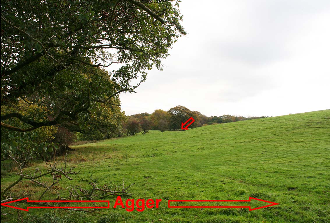
Agger descending to Mewith Lane Back on the ground - it is hard to understand how the Ordnance Survey missed this. The Roman Road has to cross Mewith Lane somewhere and even from a car it is obvious where it really does cross. The trees mask the agger somewhat but it is still unmistakable. Image: DR |
Click for larger view |
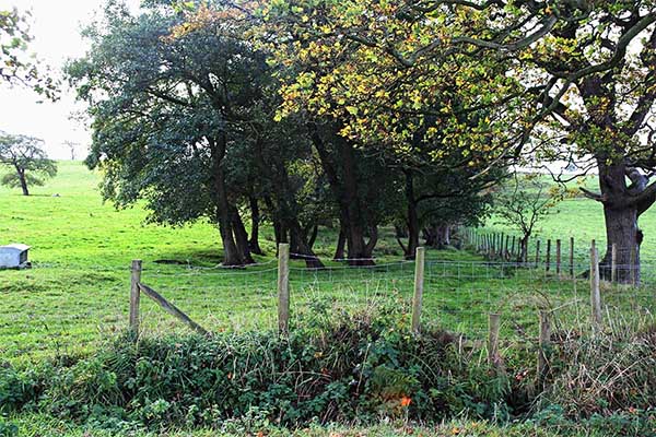 |
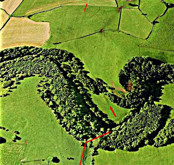
Agger below Romano-British(?) enclosure (SD 6430 6914) Between Escow Bridge and the River Wenning the Roman road skirts around a hill with what looks like a Romano-British Enclosure on top of it (see next 3D image). It is reasonably easy to locate and this picture was taken from the public footpath. Image DR
|
Click for larger view |
 |
3D Oblique Lidar Image - River Wenning Crossing This was a bit of a puzzle as there appears to be two crossings. What we decided (Hugh Toller and myself) was that the one shown is the second crossing. An earlier one probably descended where the road first bends left and crossed the Wenning bottoms to the same ascent cutting. For some reason this was replaced by the route highlighted and a new descent cutting created but it still used the same ascent on the north bank. The first route shows very faintly in the Lidar data.
|
Click for larger view |
 |
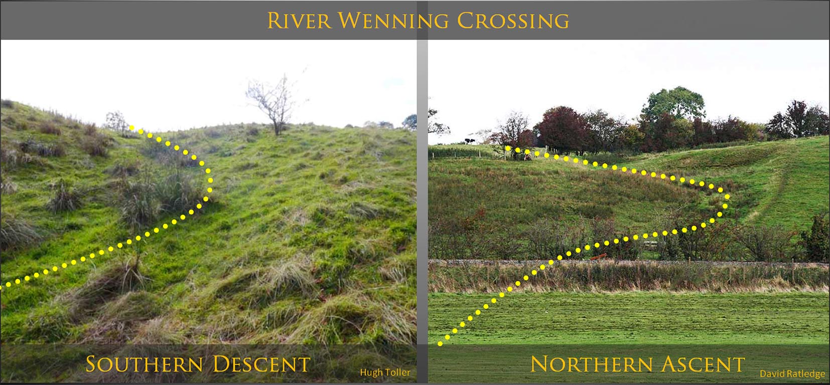
River Wenning Crossing - Descent and Ascent Cuttings Both cuttings are similar in principle - curving to ease the gradients.
|
Click for larger view |
 |
Aerial Photo of River Greta Crossing - Descent and Ascent As is typical of Roman engineering the road angles across the slope to get down to the River Greta. Having crossed the river (back in Lancashire), the road ascends Windy Bank (SD632720) in a north-westerly direction before turning back north onto the accepted line. Image: Google Earth
|
Click for larger view |
 |
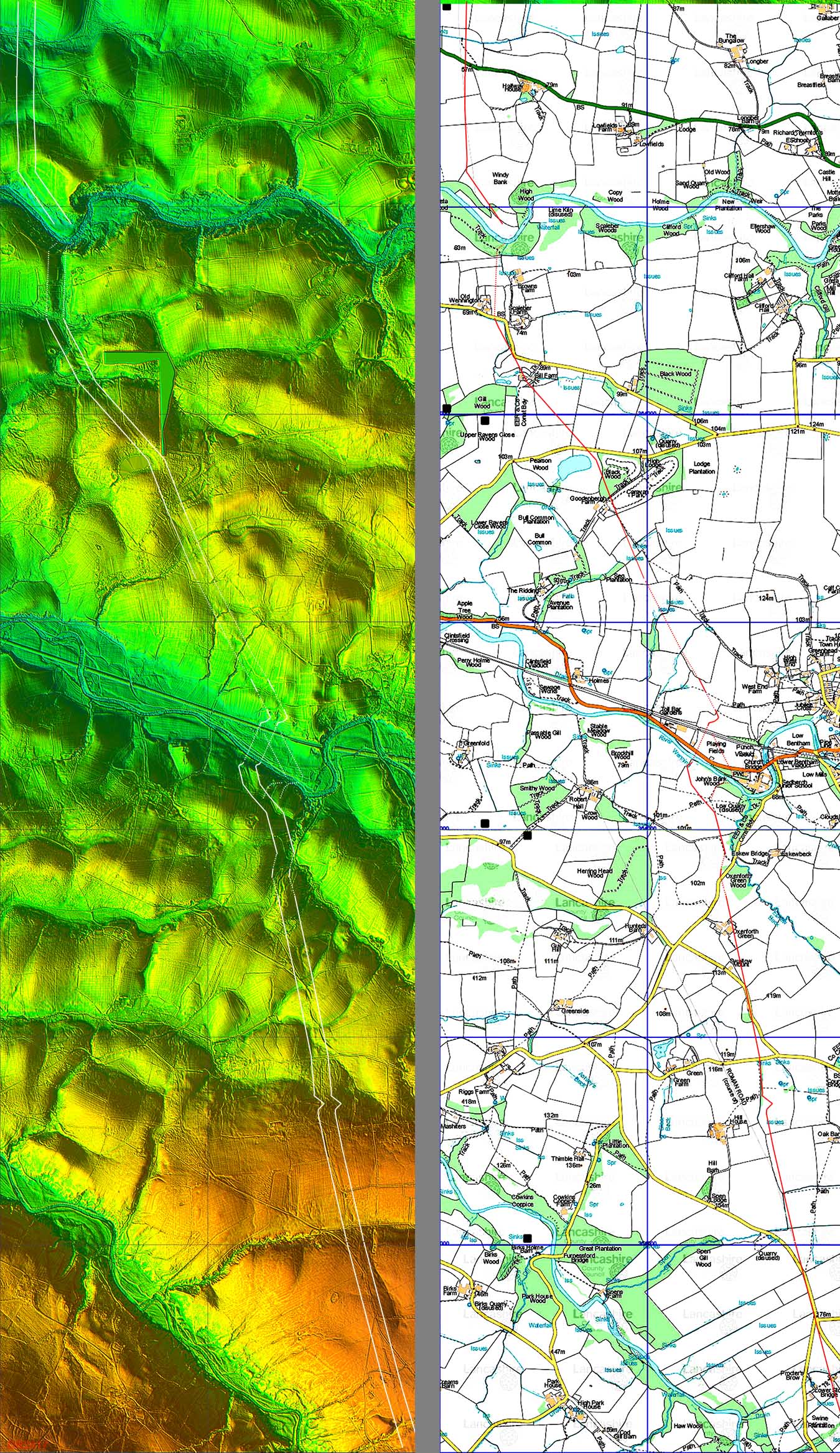
Lidar Image and Route Map - "new" section Lidar has provided the correct course of the Roman road from the Hindburn Valley to north of the River Greta. The map includes the two probable routes crossing the River Wenning. The original being the eastern one, the final the western one. |
Click for larger view |
 |
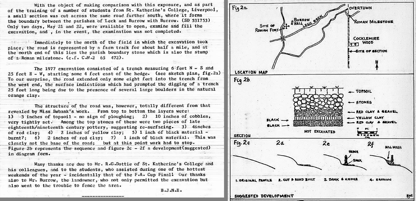
Excavation Report - Ben Edwards 1977 (SD 630 753) Ben Edwards, the former County Archaeologist for Lancashire, led an excavation of the road south of Burrow in May 1977. The report (right) is from the Lancashire Archaeology Bulletin (LAB) 1977. It would appear that only the eastern half of the road was excavated as the remainder was on the western side of the hedge and covered by soil creep. There was no mention of a eastern ditch. Late C18/C19 pottery was found on the road surface indicating it was probably still in use then - 1400 years after the Romans had left! The excavation Ben was comparing it to was one carried out near Castleton (Cumbria) by Miss Ewbank. Thanks are due to Peter Iles for digging out this article and he also pointed out that the NGR quoted in the article is wrong. My suggested correction is SD 630 753. |
Click for larger view
|
 |
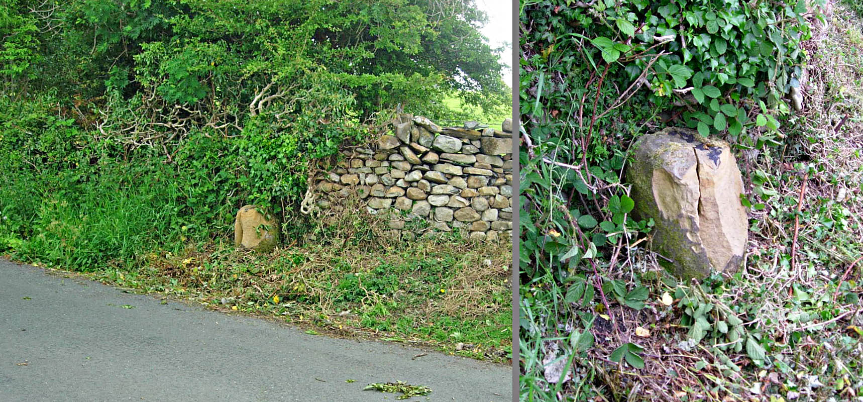
Burrow Milestone Just before the road reaches Leck Beck alongside is the stump of a Roman Milestone. It on the boundary of Burrow and Leck Parishes. The precise location is shown on Ben Edwards plan above rather than the position shown (at the time of writing) on Historic England's entry. The milestone is ancient monument no. 1003131. In 2020 the milestone was badly damaged presumably by verge clearing machinery(?). A few pieces were knocked off and the stump split in two. it is understood discussions are taking place regarding repairs. Thanks to Graham Ransom for bringing this to my attention. Images: Graham Ransom |
Click for larger view
|
 |
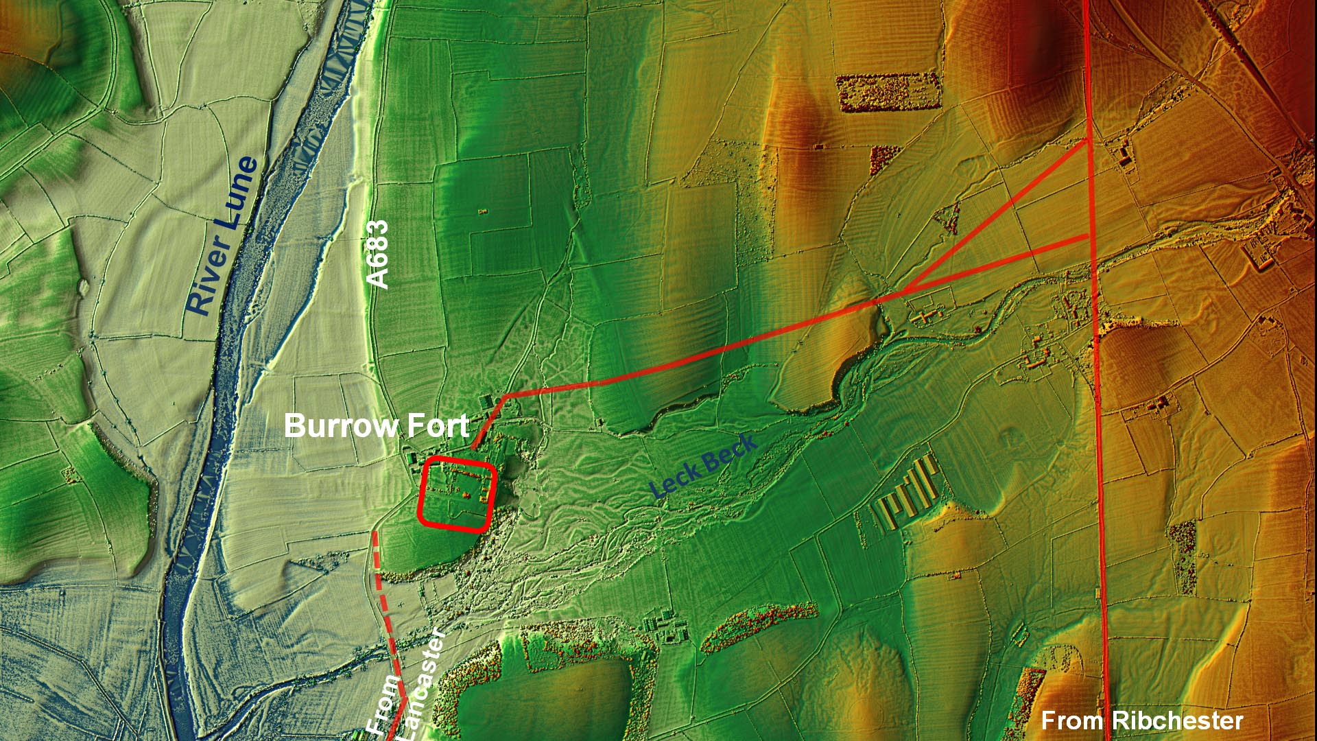
Burrow Fort - Lidar Image and Link Road Route Map Our northward bound Roman road passes around 1 mile to the east of Burrow Fort. A link road to Burrow would have been required and Lidar has revealed its course, perhaps surprisingly on the north bank of the Leck Beck. What is also clear from the Lidar image is how big the flood plain of the Leck beck is. The road keeps well clear of it. At its eastern end the link road almost certainly bifurcates with one branch for traffic to the north and one for traffic from the south. The important consequence of this road arrangement is that it implies that the road from Ribchester was here earlier than the road from Lancaster. It is the Ribchester road that unerringly carries on northward not the road from Lancaster. This would put in serious doubt the theory that the road from Lancaster was the earliest conquest road (ref. Shotter). The Ribchester road would seem to have won that battle. For details of the Burrow Fort, vicus and possible watch tower see Margary 705 |
Click for larger view |
 |
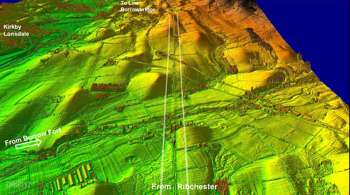
3D Oblique Lidar Image - Looking North Our road can be clearly seen continuing on almost due north over the county boundary into Cumbria. For its continuation to Low Borrowbridge - see Cumbria section |
Click for larger view |
 |
3D Oblique Lidar Image - Possible Marching Camp Still in Lancashire - just - is what looks like a possible marching camp? If so this would be the first known in Lancashire. I have about 50% confidence for this - not really certain. |
Click for larger view |
 |
|
|
|
Last update: July 2024 |
© David Ratledge |