|
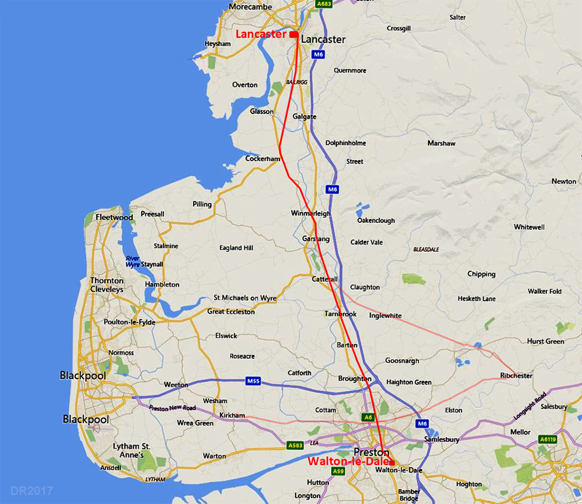
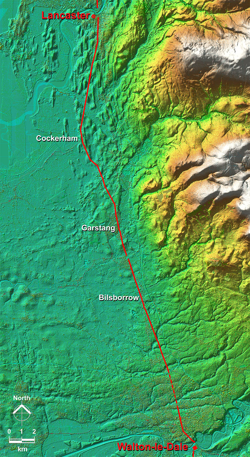
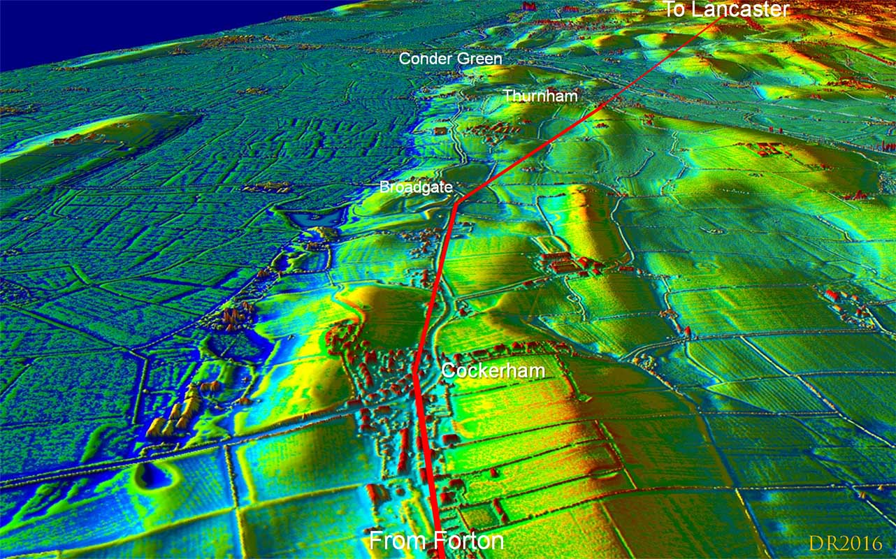
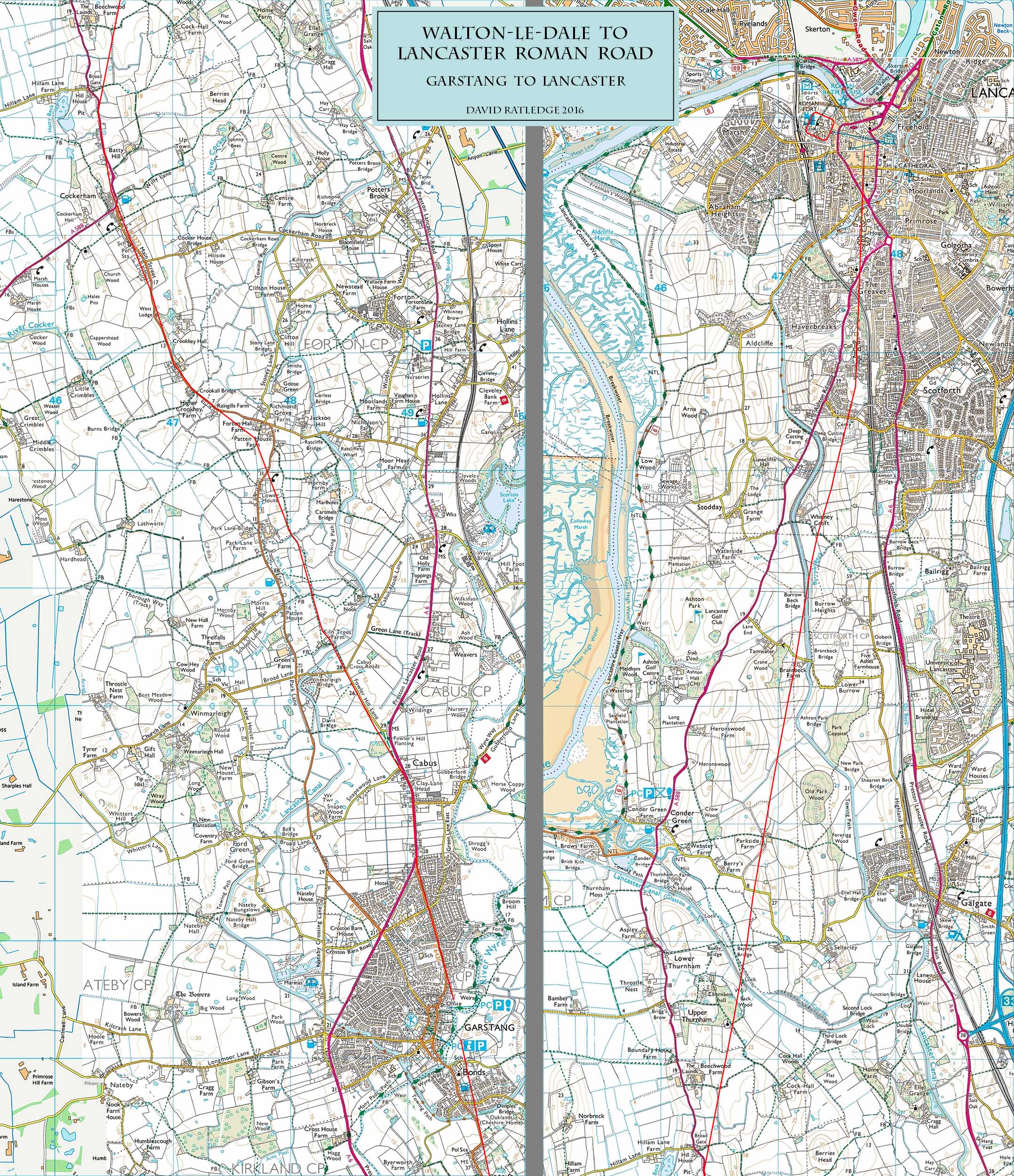
The Roman Road from Walton-le-Dale to LancasterMargary Number: 70dDistance: 23 milesThis is one road that virtually everyone had a theory as to where it was located but evidence never seemed to be forthcoming for any of the suggestions so in reality its course was unknown. Lidar has at last revealed its true course and very little of the route found coincides with any of those previous suggestions. Fowler Hill Lane just north of Garstang is probably the only short length that turned out to be correct. Nobody had expected it to go via Cockerham! UPDATE 2024: Milestone Discovered in Garstang |
Historic County: Lancashire Current County: Lancashire HER: Lancashire
|
|
|
|
|
|
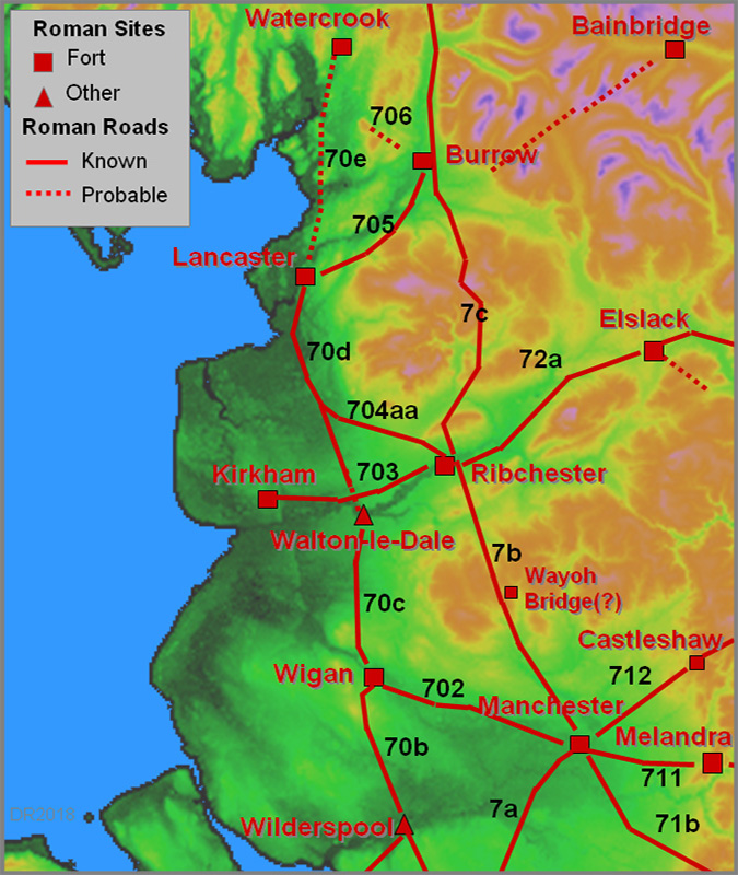
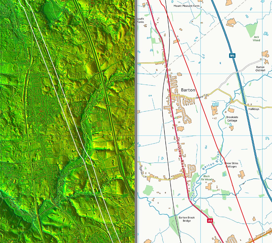
Lidar Images - Full Route When you look at the topography then the route chosen does make a lot of sense. The coastal connection at Cockerham clearly was part of the design. The alignment from Walton aims for Cockerham and so does the alignment south from Lancaster. This is one case where drawing a straight line between Roman sites does not work! Note also the glacial striations and drumlins very evident south of Lancaster. A glacial striation at Galgate fooled everybody into thinking that was the Roman route but Lidar showed it for what it was - a natural feature. The road never went via Galgate.
|
Click for larger view |
 |
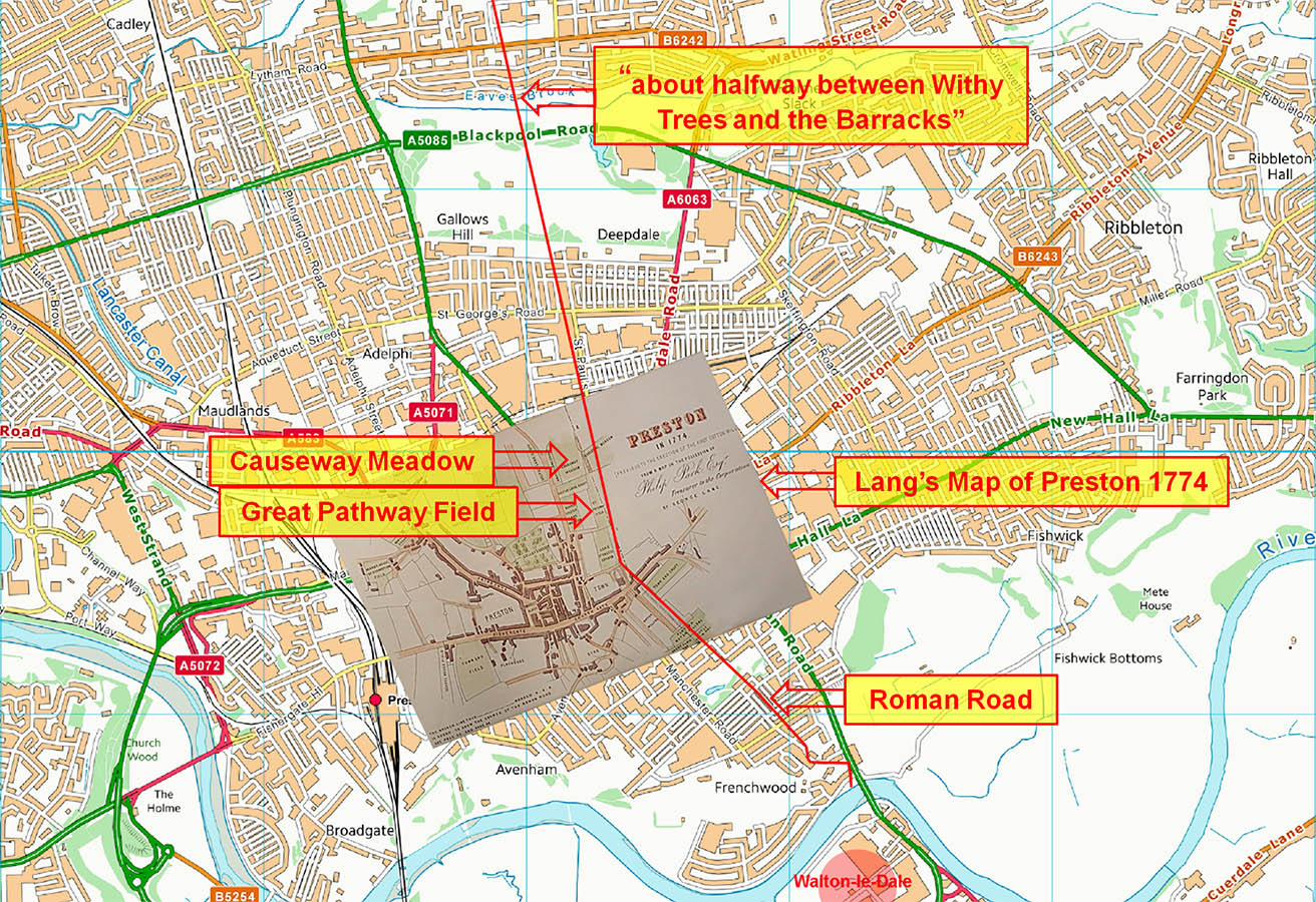
Clues across Preston At Preston the Ribble was crossed just downstream of London Road Bridge and the line across Preston is probably marked by Swill Brook Lane and Roman Road (that's a clue!) before crossing Church Street near Grimshaw Street. Lang's map of Preston 1774 names two fields as 'Great Pathway Field' and 'Causeway Meadow' and gives an indication of the route of the road. However, getting the map to fit a modern map requires some distortion but we at least have an approximate position for the road. There are 150 year old reports of the road being discovered when Lower Bank Road in Fulwood was being developed. The exact location was unfortunately not recorded - just "about halfway between Withy Trees and Fulwood Barracks". There is a possible Lidar trace across Moor Park supporting this line.
|
Click for larger view |
 |
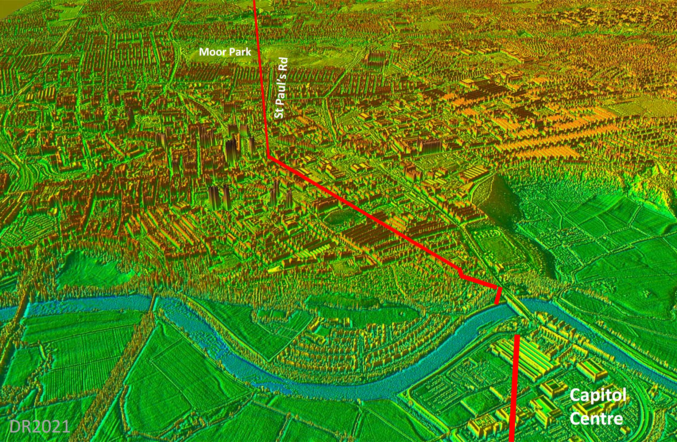
3D Lidar Image - Preston The equivalent view to that shown on the map above. The alignment that beigin probably just north of Church Street would most likely be direct to Banister Hill. - see later. |
Click for larger view |
 |
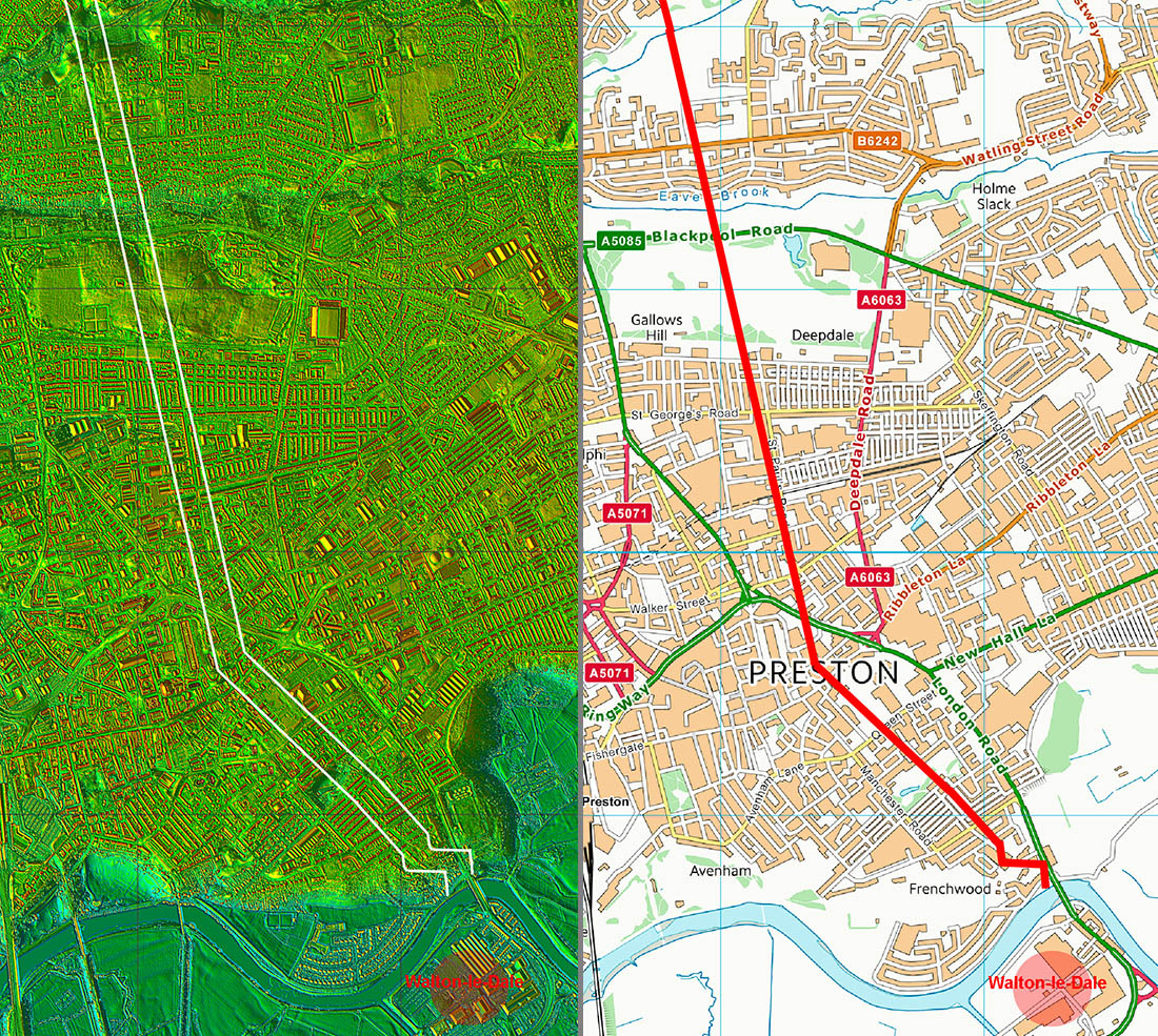
Lidar Image and Map 1 - Preston We are reliant on those old accounts to plot our road across Preston. There are some indications perhaps across Moor Park to support these but how much landscaping took place for the park is unknown.
|
Click for larger view |
 |
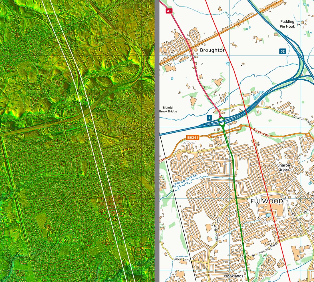
Oblique 3D Lidar Image - looking north across Fulwood The general direction from Preston seems to have targetted the west side Banister Hill, next to what is now the M55 motorway. There was a change of direction there all the way to beyond Bilsborrow. This is the latest series 2 DTM lidar.
|
Click for larger view |
 |
Lidar Image and Map 2 - Fulwood & Broughton Beyond Watling Street Road in Fulwood, the road has been notoriously difficult to ascertain with many theories over the years but with little hard evidence. Having said that, the route across Fulwood is somewhat joining the dots but there is a logic to it. The alignment from Watling Street Road appears to be aiming for Banister Hill, Durton Lane - it is typical Roman surveying to utilise a high spot. Broughton Bypass is not shown on this map but is shown in the series 2 lidar data.
|
Click for larger view |
 |
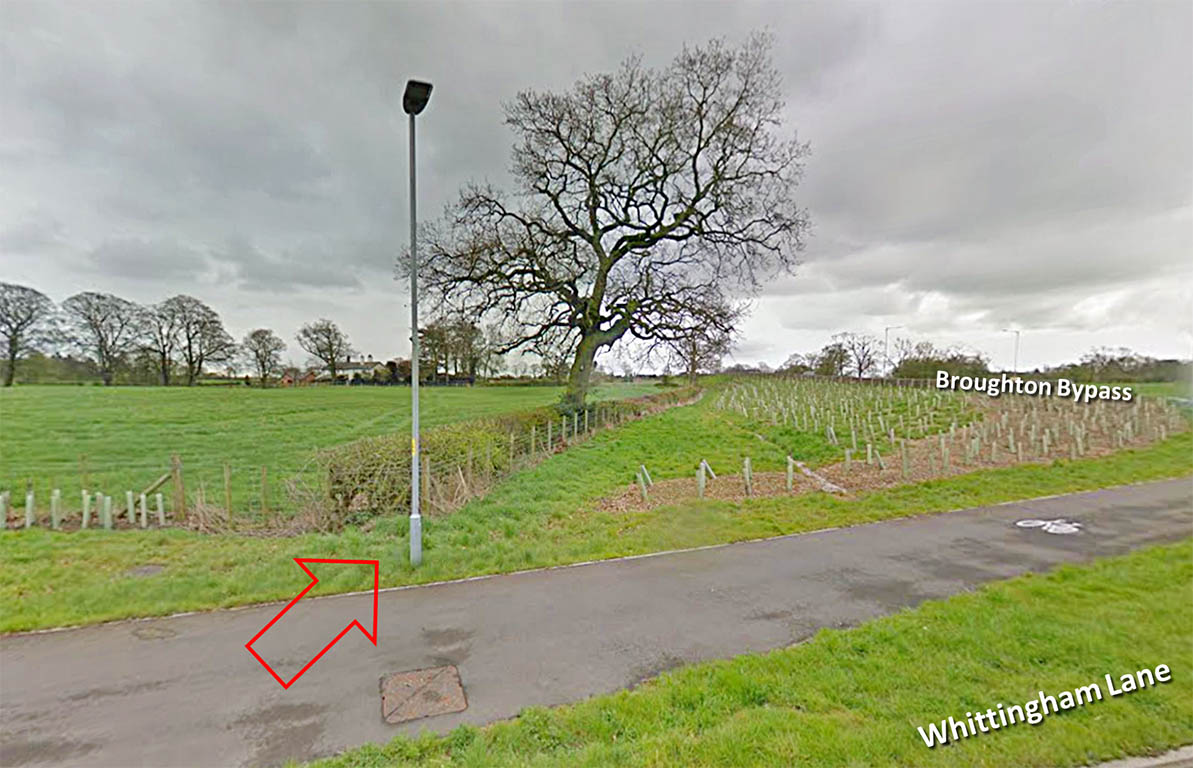
Whittingham Lane, Broughton Is this the line of the road? This hedgeline fits best with the alignment coming down from Barton. There are no reports of the road being spotted when the bypass was constructed but of course Lancashire doesn't have a County Archaeologist these days. This is looking south with the roundabout to the right. In the light of the UU excavation (below) we can now be confident this is the road line. |
Click for larger view |
 |
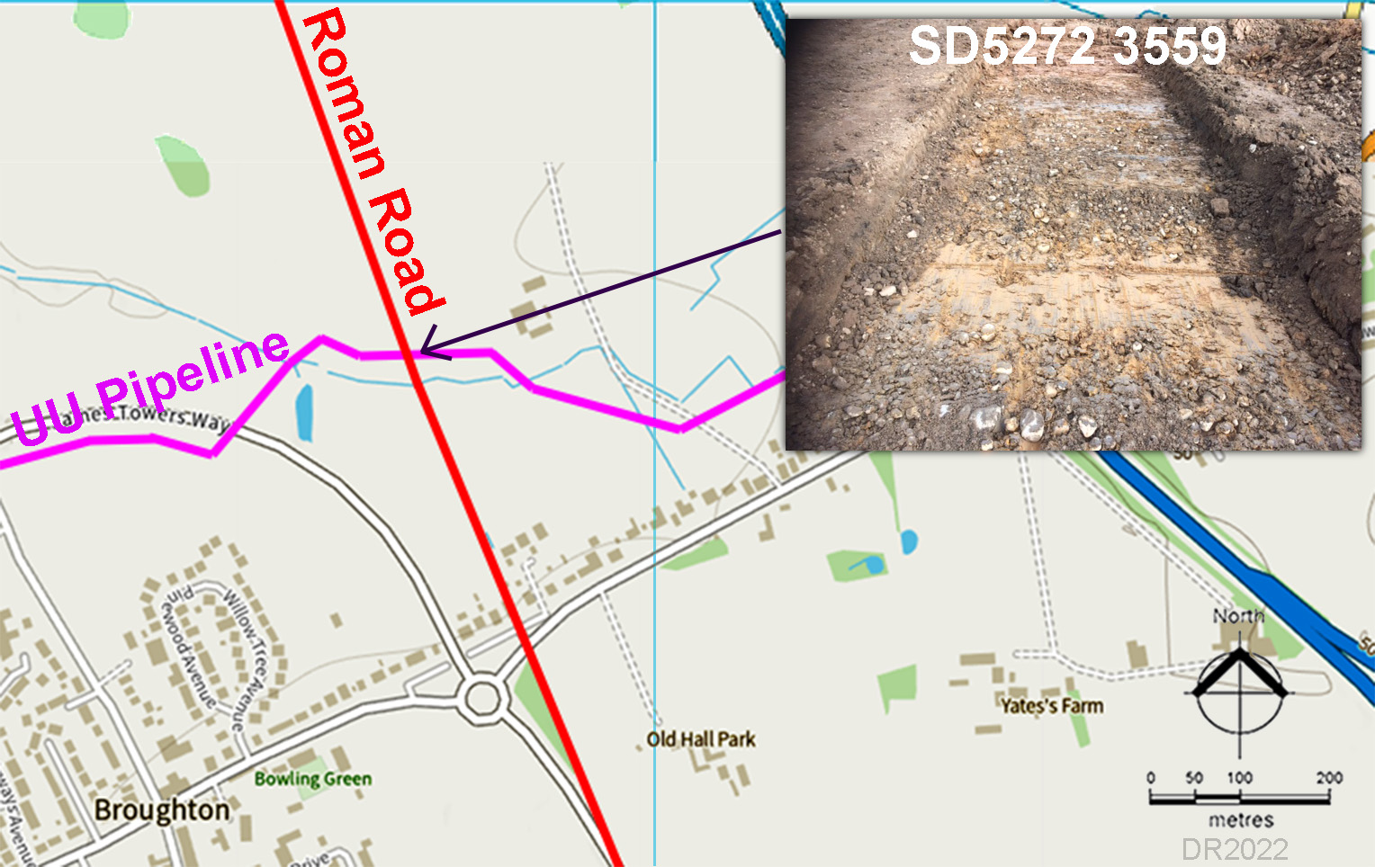
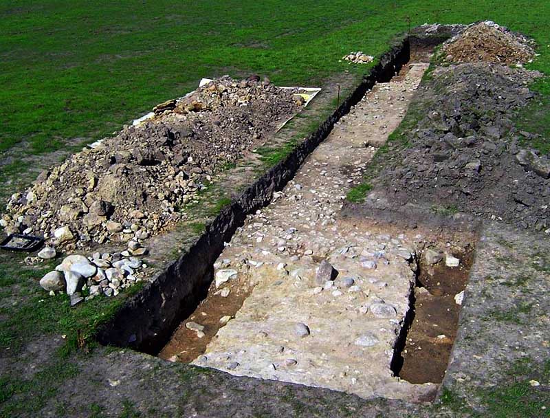
Broughton - UU Pipeline Excavation 2021-2022 This was an opportunity too good to miss when UU proposed a pipeline across Broughton which would intersect with the road. Wyre Archaeology managed to get permission to walk the trench and Andy Jackson was able to attend at very short notice. Bang on the suggested line Andy found a definite scatter of stoines. There were sufficient (only present of the Roman road line - none elsewhere) to prove this was indeed the remains of the road. This is believed now to be the furthest south fixed point for the road as Broughton Bypass did not find (notice) the road - a big opportunity missed. |
Click for larger view |
 |
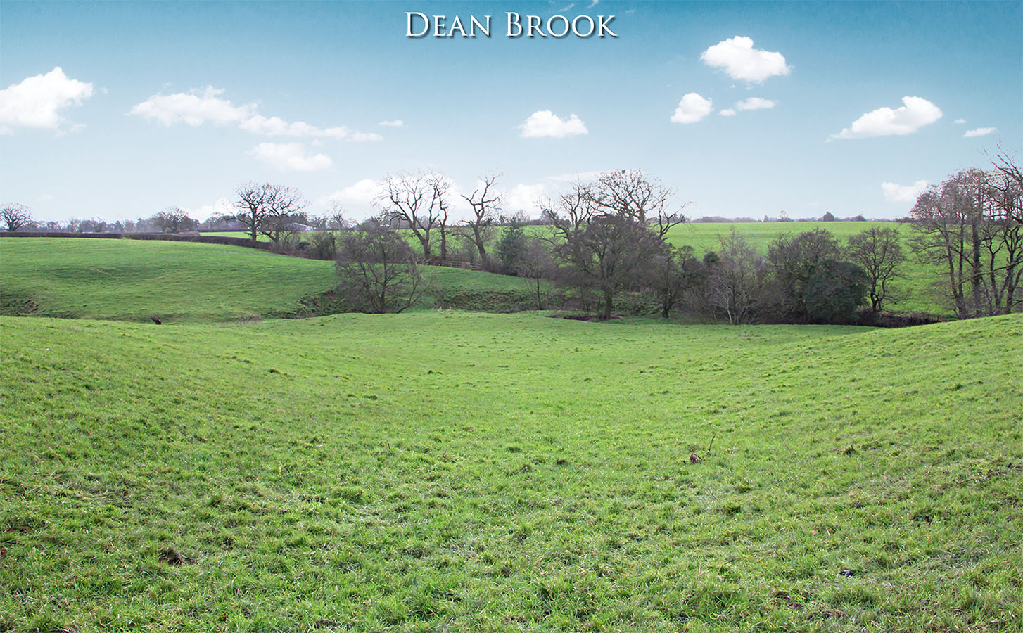
Dean Brook - looking south We are looking back towards Dean Brook on its northern bank. The road ascends in an obvious cutting. There is another cutting east of this one but it is off line so, on balance, this is likely to be the correct one. It does line in with the agger visible in the Lidar data passing Duck Wood. Image: DR - with thanks to Ian Milnes for obtaining permission to visit this spot. |
Click for larger view |
 |
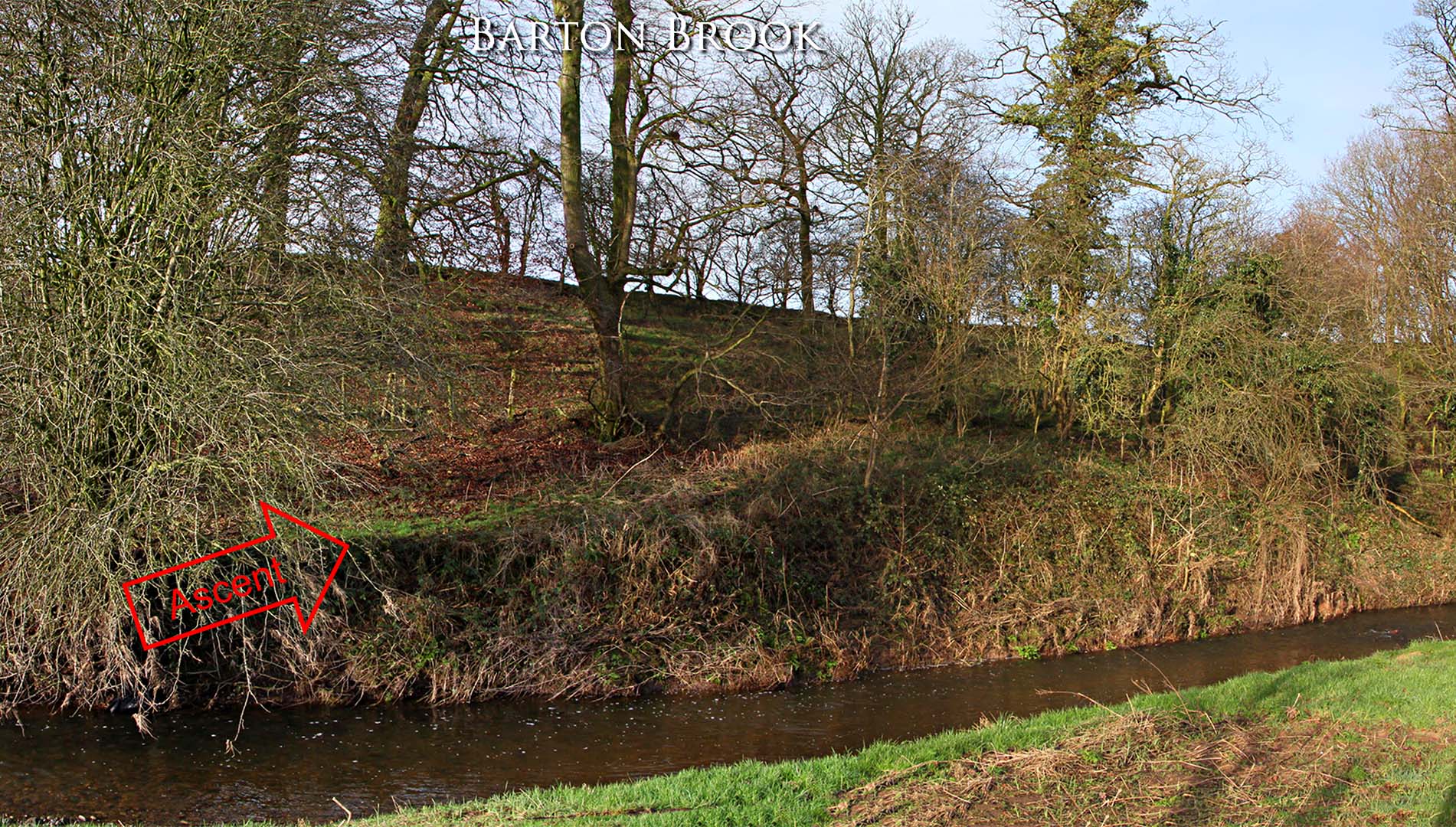
Barton Brook - Northern Ascent 1 The angled ascent on the north bank of Barton Brook is clear but it appears it has suffered some erosion damage over the centuries. Image: DR - with thanks to Ian Milnes for obtaining permission to visit this spot. |
Click for larger view |
 |
Barton Brook - Northern Ascent 2 We are now at the top of the slope with the road coming up from the left. The road has survived much better here. Image: Ian Milnes. |
Click for larger view |
 |
Lidar Image and Map 3 - Barton The route passing Barton is visible in the Lidar imagery from Dean Brook, Barton as far as Bilsborrow. It is faint but definite. So the A6 at Barton despite looking like a Roman road turns to be not Roman at all. It is in fact a turnpike road. The "chicane" in the Roman road south of Bilsborrow looks odd but is typical sensible Roman engineering - moving off line to negotiate a stream/valley. There is also a length of Roman agger visible south of Dean Brook heading for Broughton. |
Click for larger view |
 |
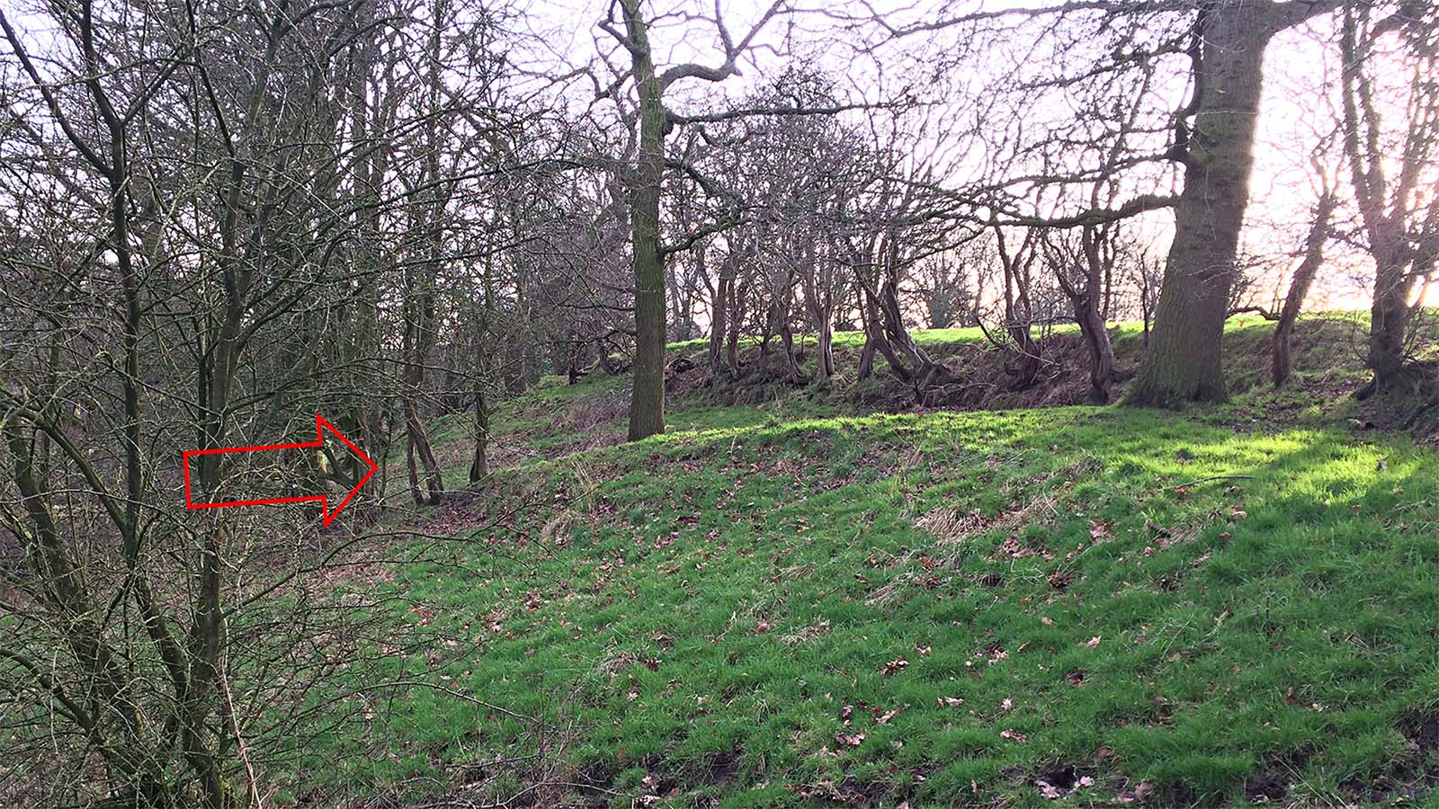
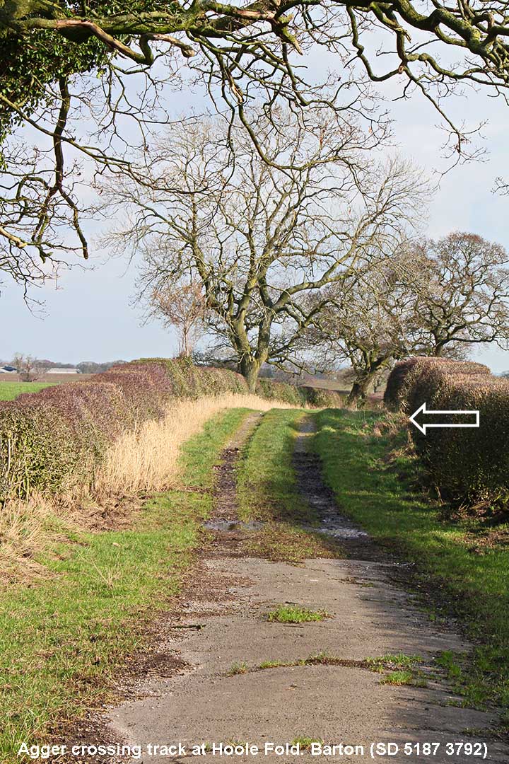
Hoole Fold, Barton - agger crossing track The route passing Barton might be clear in the Lidar data but difficult to spot on the ground. However, where the track at Hoole Fold crosses it at right angles the swell of the agger is obvious. A common occurrence - a minor track crossing a Roman road having to climb up over the agger. Image: DR
|
Click for larger view |
 |
Agger near Anderton Fold - approaching Bilsborrow Approaching Bilsborrow there is evidence on the ground for the road in two spots just south of Bacchus Brook, both visible from a public footpath. The first is south of the footpath/track passing Anderton Fold just north of the chicane. The chicane is visible in the distance from here but not accessible - binoculars advised. Image: DR
|
Click for larger view |
|
Cutting descending to Bacchus Brook, Bilsborrow The second is north of the footpath and is the approach to Bacchus Brook - a significant name perhaps? Here the road is in a cutting heading down to the brook. I did take a close look at the brook crossing but could see no evidence of any surviving bridge abutments so perhaps a simple ford. Image: DR
|
Click for larger view |
|
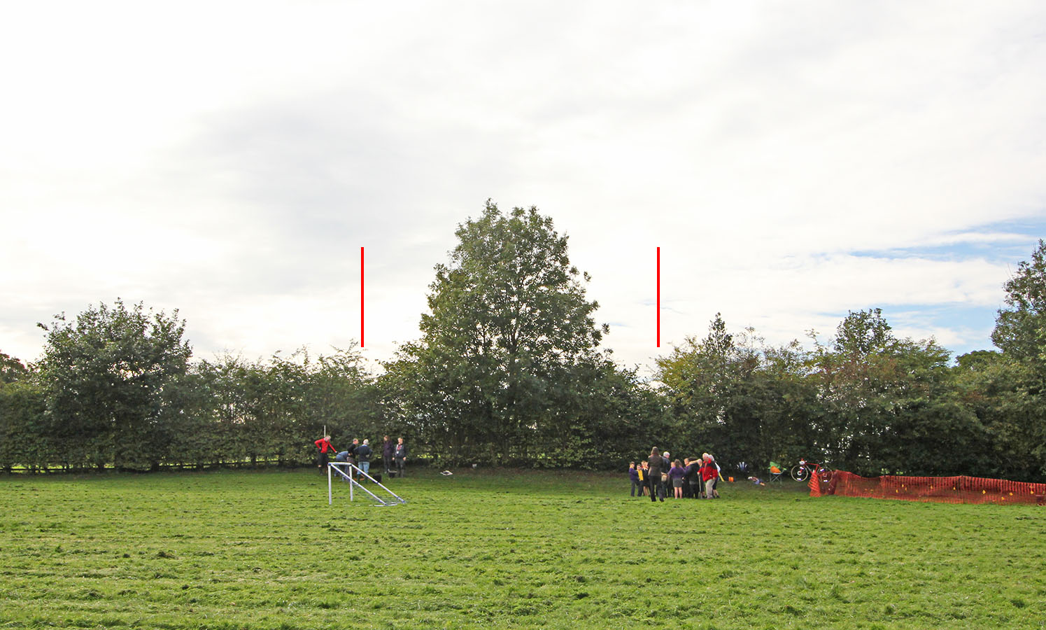
Bilsborrow Across Bilsborrow it is a case of interpolation with perhaps just one clue. Wyre Archaeology carried out a 2 day excavation in the school playing field at Bilsborrow John Cross C of E Primary School in September 2018. The children were able to get some first hand experience of an archaeological dig but the road proved elusive but there was one clue - see next image.
|
Click for larger view |
 |
Bilsborrow: Ecavation at John Cross C of E Primary School Playing Field, 2018 - looking south. The playing field had clearly been bull-dozed flat to provide a level football pitch but in the hedge was the most obvious of swells. David Hampson, Wyre Archaeology, is busy explaining what had been found to the children. A swell such as this is a common occurrence where Roman roads pass under hedge-lines and it is on the interpolated line shown above so could well be the Roman road. Image: DR
|
Click for larger view |
 |
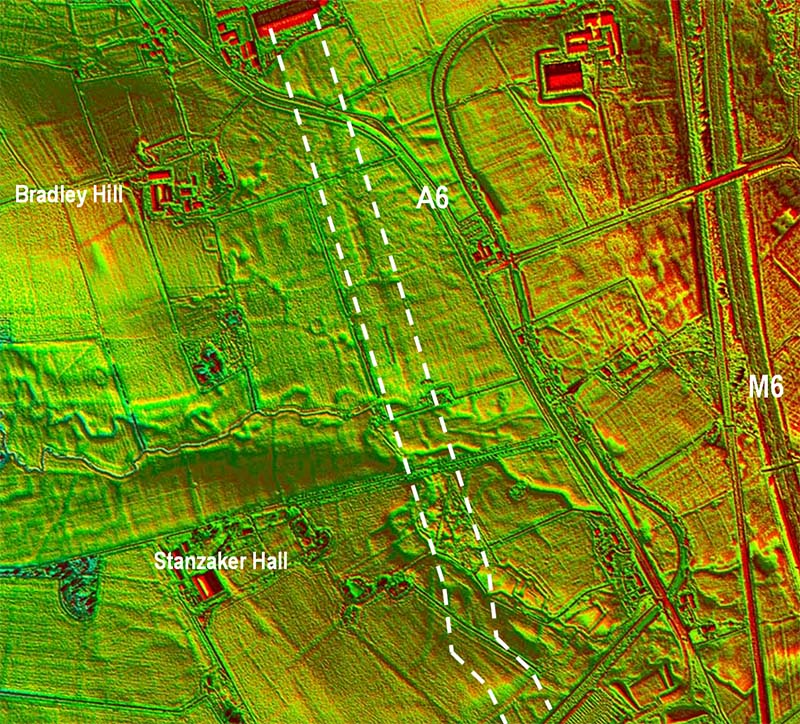
Lidar Image - Stanzaker Hall Farm This was the key Lidar image that began the process of finding the course of the road from Walton-le-Dale to Lancaster. What Lidar has now revealed is that the Stanzaker Hall cobbled road (see next image) is just part of an impressive length of straight agger of unmistakable Roman characteristics. It is clear across several fields and a small wood. This settled the argument once and for all and provided a base point to work out from. From this point the road could be traced both north and south.
|
Click for larger view |
 |
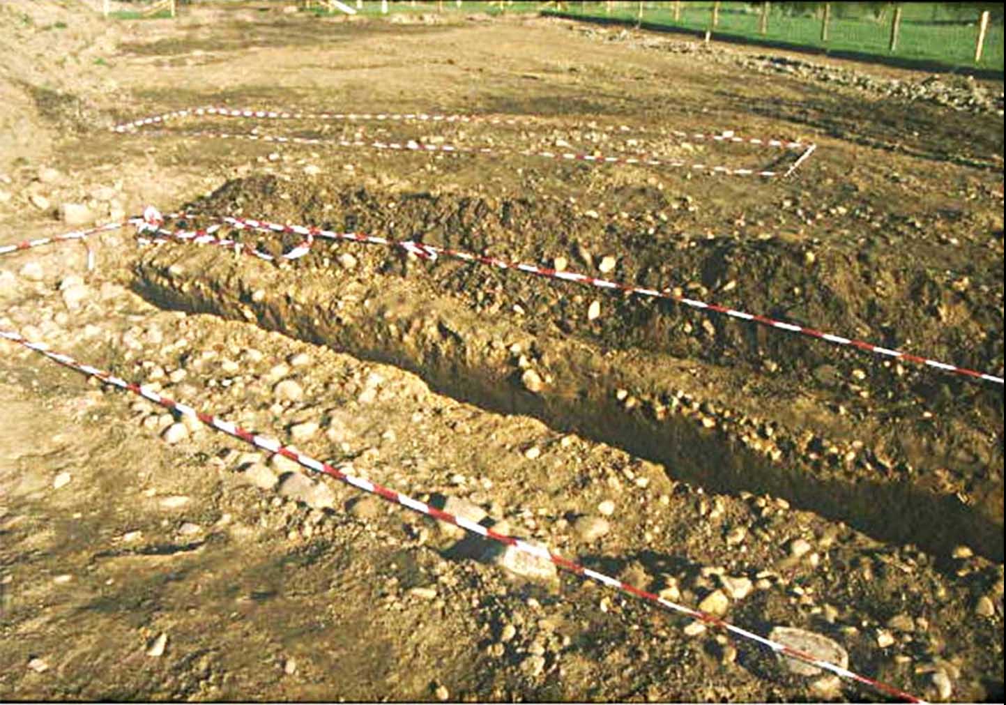
Pipeline excavations 2002, Stanzaker Hall It was first spotted several years ago by Peter Iles on an aerial photograph. It was in a field just west of the A6 near Stanzaker Hall and, when a pipe line crossed it, a cobbled structure with ditches was found . Yet doubts still remained as to whether this was indeed Roman. There were several other candidates around Garstang - one even with its own cobbled road too. Image: Peter Iles
|
Click for larger view |
 |
River Calder Crossing - Contour Map Despite extensive on site searching and numerous trial pits by my colleague Andy Jackson no sign of the Calder crossing has emerged. Perhaps not a surprise as clearly the course of the Calder and other streams have been altered and several mill ponds constructed. The road alignments south and north of the Calder are not aligned and there must have been a good reason for this. Perhaps avoiding meanders in the original course of the Calder was the explanation. The road in from Richester was clearly targetting a common bridge.
|
Click for larger view |
 |
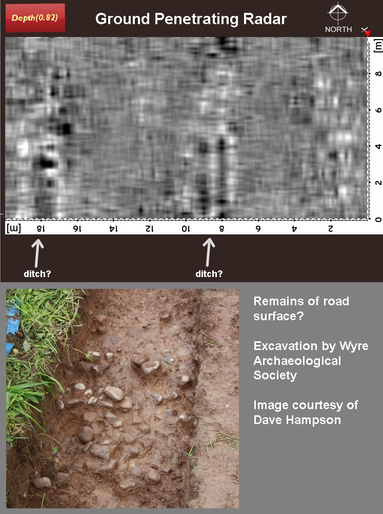
Bowgreave Excavation 2016 Northward from Stanzaker Hall, the road would have headed over over Bowgreave Hill - a very probable alignment point. It probably coincides with Garstang Road (B6430) at Gryersdale Bridge/Calder Bridge and again beyond Bowgreave Hill passing Bowgreave Rise Care Home towards the canal bridge. On this alignment, in 2016 near to Garstang Community Academy, probable traces of the road were located using ground penetrating radar (GPR) carried out by Wigan Archaeological Society on behalf of Wyre Archaeology. Two parallel features were recorded which were interpreted as the ditches of the road (grid ref withheld at Landowner's request). A subsequent excavation by Wyre Archaeology confirmed the direction of the features matched the Roman road alignment but surviving traces of the road were fragmentary. It would appear not much had survived ploughing here. GPR image: courtesy of Wigan AS (Bill Aldridge) Excavation image: courtesy of Wyre AS (Dave Hampson)
|
Click for larger view |
 |
Agger north of Castle Lane Possibly the best surviving stretch of agger on the whole road. This is the view from the modern Wyre Bridge with the ridge of the Roman agger on the far side of this field heading for its crossing of the River Wyre beyond the big tree. Image: Andy Jackson
|
Click for larger view |
 |
3D Lidar Image Garstang - looking south Continuing this alignment on towards Garstang, there is a very prominent agger visible in the lidar data north of Bowgreave Hill and Castle Lane approaching the Wyre (SD4947 4508). It does appear, on the basis of the Lidar image, that the bridge's south-east abutment could have survived - see below.
|
Click for larger view |
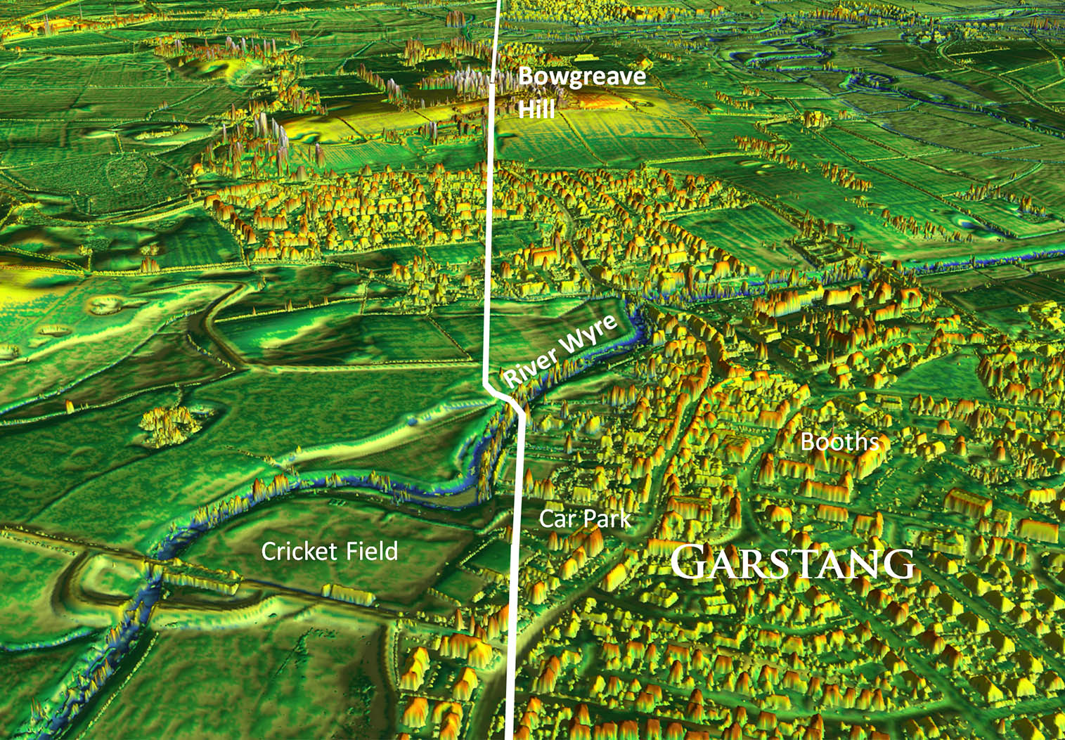 |
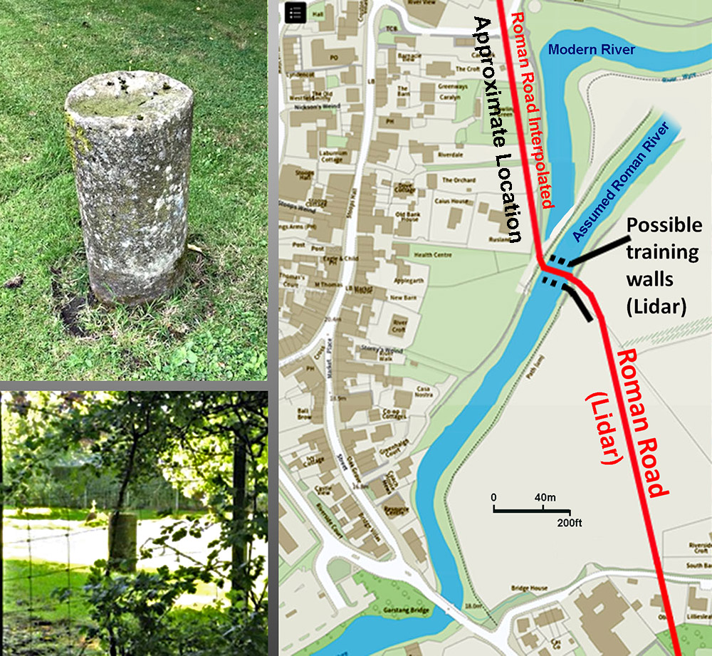
Roman Bridge over the River Wyre & Milestone Lidar indicates the road coming in from the south turning between what could be wing walls for a bridge across the Wyre. The river would have been straighter - horse-shoe bends increase over time. The milestone was discovered by Andy Jackson in 2024. The exact location cannot be divulged so only the "approximate location" is depicted. For more details of the milestone - see Lancashire Milestones Images: Andy Jackson. Base Map: LCC Mario
|
Click for larger view |
 |
Route Map, Garstang Detailed map of the route across Garstang. North of the Wyre it probably crossed the football pitch near the riverside picnic spot and then continued on or near to the modern road to Cabus.
|
Click for larger view |
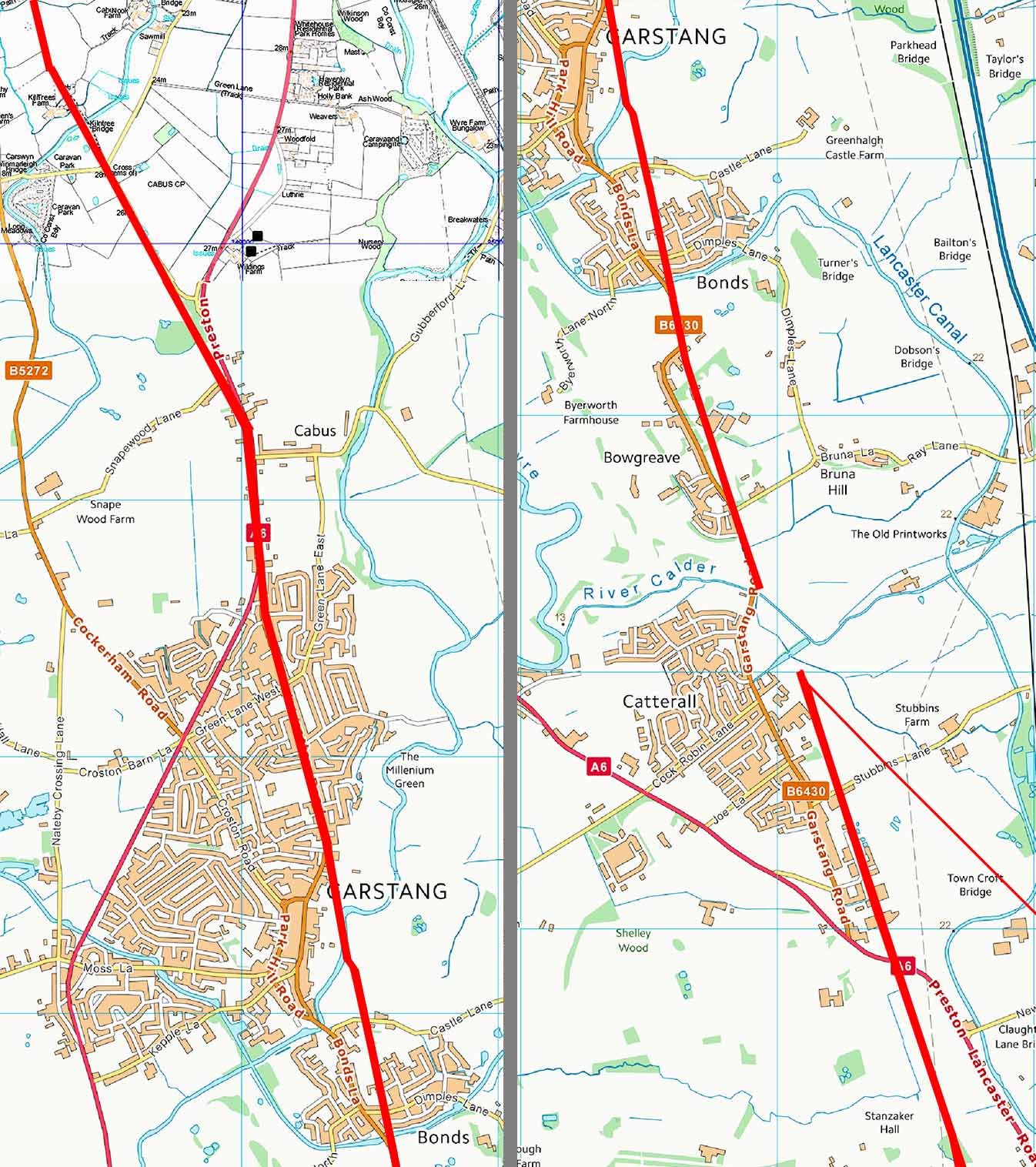 |
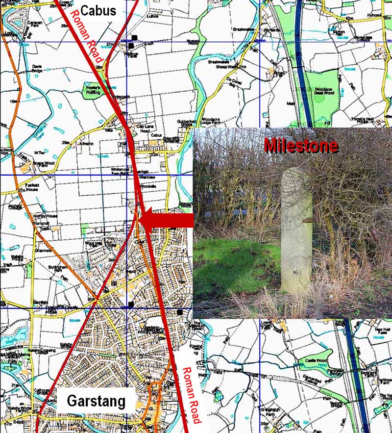
Roman Milestone, Cabus Toll House The confirmation of the route towards Fowler Hill Lane lead to the penny dropping as to the nature of the west gate post of the Turnpike Cottage at Cabus. Hiding is full view was a Roman Milestone! It so typically Roman with a square base and round top. The east gatepost here is totally different and appears banded. It looks like the turnpike trust simply commandeered the Roman milestone for use as a gate post - all they had to do was add a gate stop visible in the picture. Peter Iles was in agreement with my interpretation and has applied for it to be scheduled. Because of its proximity to the hedge it very difficult to see in summer. |
Click for larger view |
 |
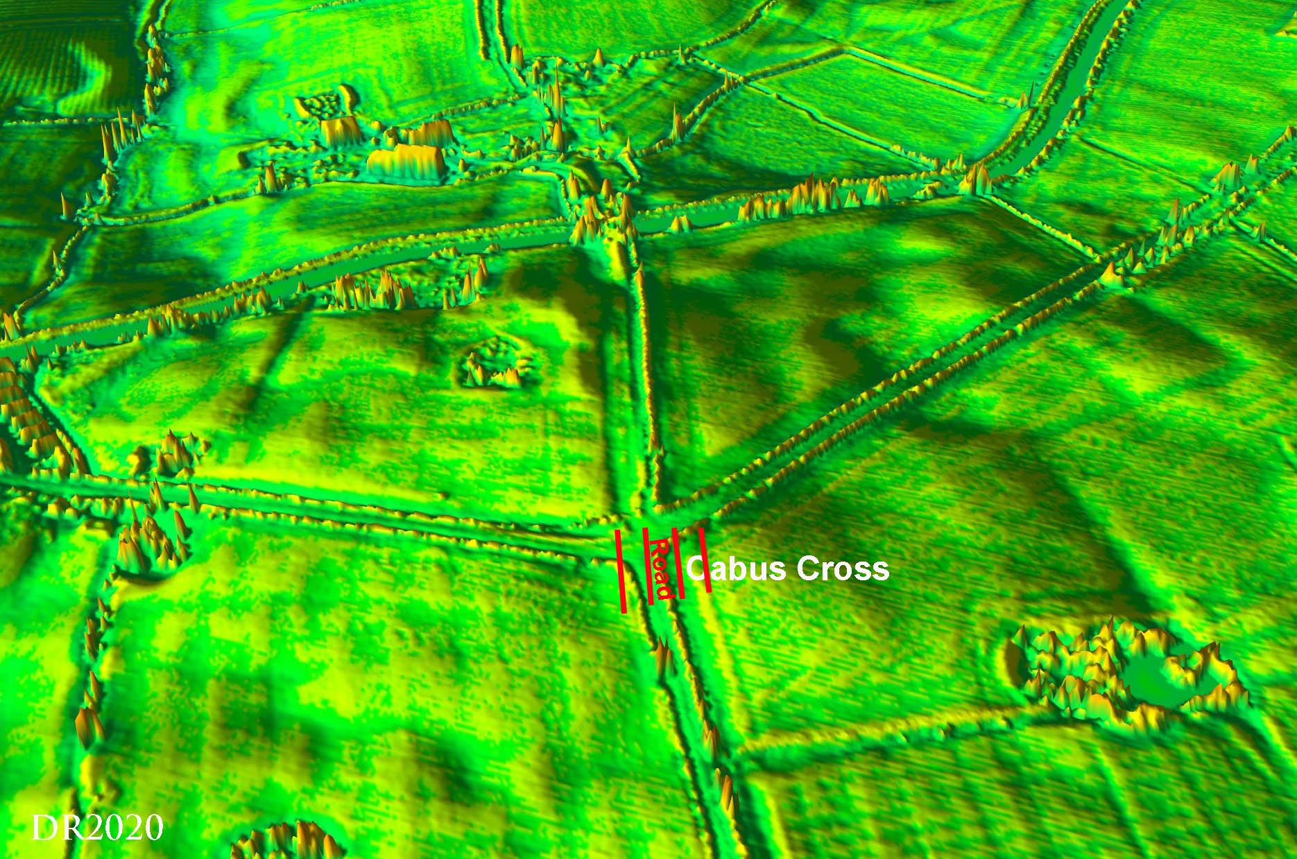
Oblique 3D Lidar Image - Cabus Cross Crossroads Latest News 2020: Following a test pit excavation it looks like we might have an example of a four ditch road layout at Cabus Cross Roads. Lidar shows a huge width and the test pit would seem to indicate that the road was in the middle third. This is tentative at the moment but would seem to be the best explanation of what the test pit excavation revealed and also what the Lidar shows. |
Click for larger view |
 |
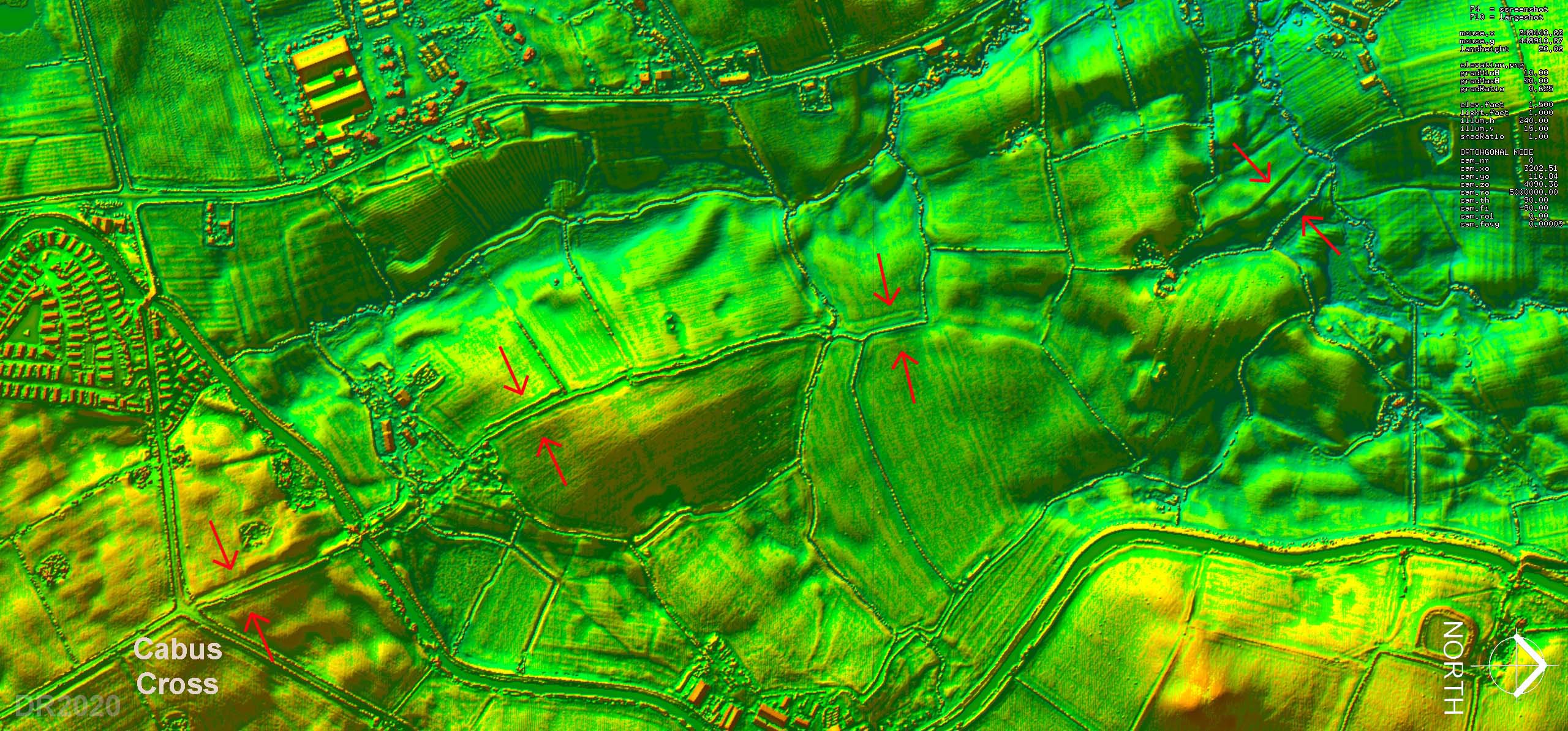
Lidar Image - Kiln Trees Lane There is some clues that the four ditch layout continues along Kiln Trees Lane. Despite being worn away in most places there does seem to be some spots where it may have survived. North is to the right in this plot.
|
Click for larger view |
 |
Kiln Trees Lane Beyond the canal, the Kiln Trees Lane marks the course approximately. This has been so worn away by traffic over the centuries that much of is a hollow way. There are a few (foundation) stones remaining but the agger is generally long gone. It is hard to believe that for over 1000 years after the Romans had left this was the main road to Scotland! Bonnie Prince Charlie and his army would almost certainly have used this road in his failed bid for the crown in 1745. Image: DR |
Click for larger view |
 |
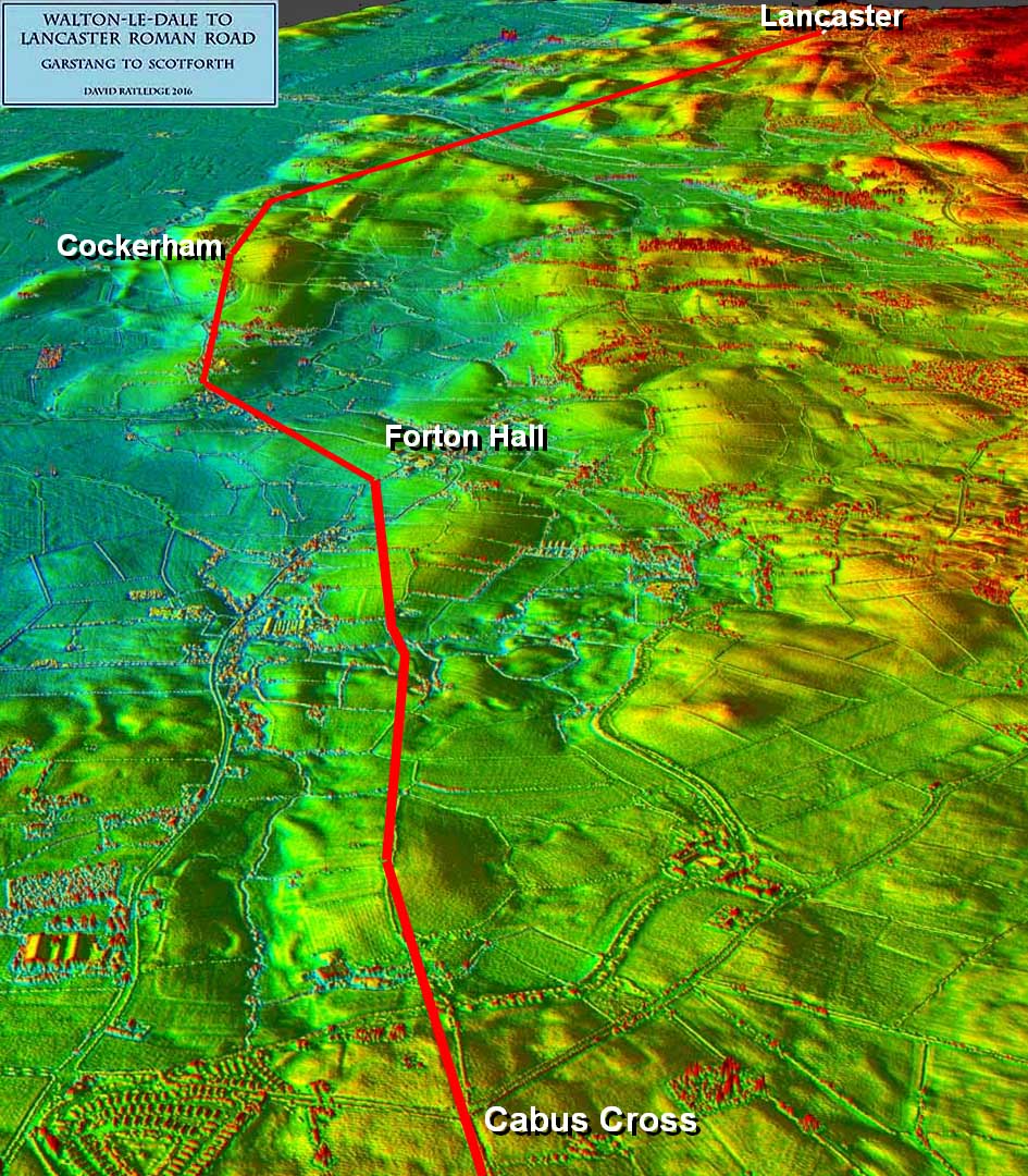
3D Lidar Image - Cabus to Lancaster The reason for the turn at Fowler Hill Lane now becomes obvious - it is aiming for Cockerham. It was the tracing of the course of the road south from Lancaster that independently confirmed this as the destination as that too was directed on Cockerham. It still took me over 12 months to believe what I was finding as all conventional wisdom said the road went via Galgate. In fact, if the direction of this road all the way from Fulwood is considered (see map at top of page), it is not directed towards Lancaster at all but Cockerham. Only after Cockerham does it change direction and take aim for Lancaster.
|
Click for larger view |
 |
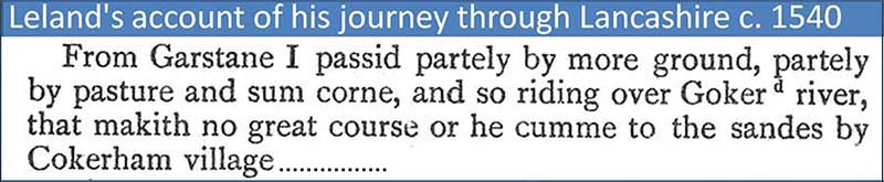
Leland's Itinerary, c. 1540 It should not have come as such a surprise. Leland's account of journey around Britain in 1539/40 includes his route through Lancashire. He was clearly still following the Roman road and his route from Garstang to Lancaster went via Cockerham. It also confirms that Cockerham village was at that time by the sea ("sandes"). Thanks are due to Bill Shannon for bringing this to my attention.
|
Click for larger view
|
 |
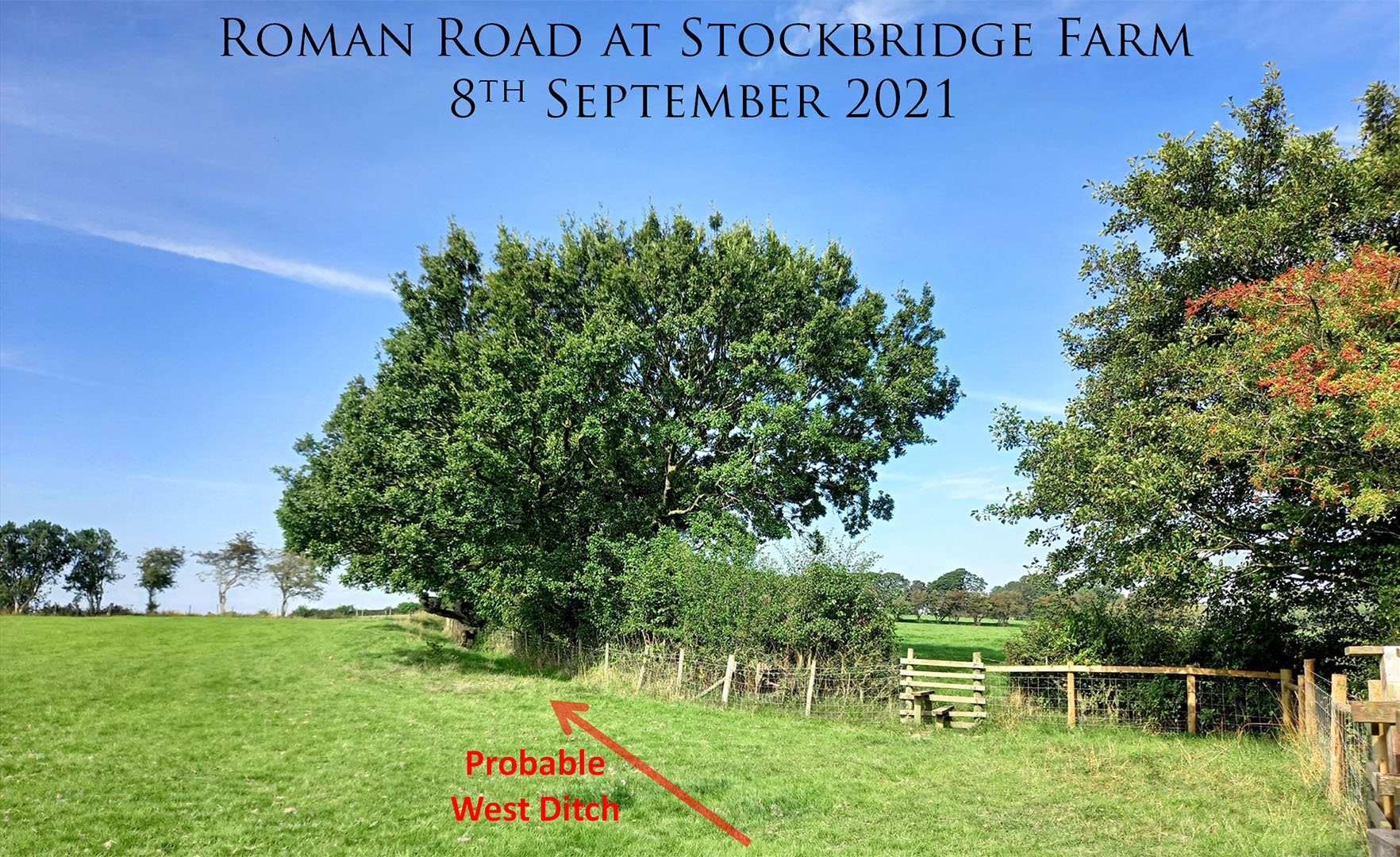
Stockbridge Farm - probable Western Road Ditch This is the continuation of Kiln Trees Lane towards Forton. On the right is a footbridge and the public path passes through a stile to the east side of a hedge. We were invited into this field by by the owner (Ken). There is a very prominent ditch which is most likely the western ditch of the Roman road. Because the land drops away to the right towards a marl pit a small cutting would have been necessary to get a level platform for the road - hence the big ditch. Image: DR |
Click for larger view |
 |
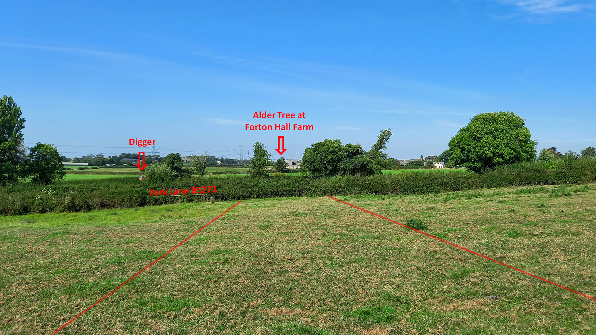
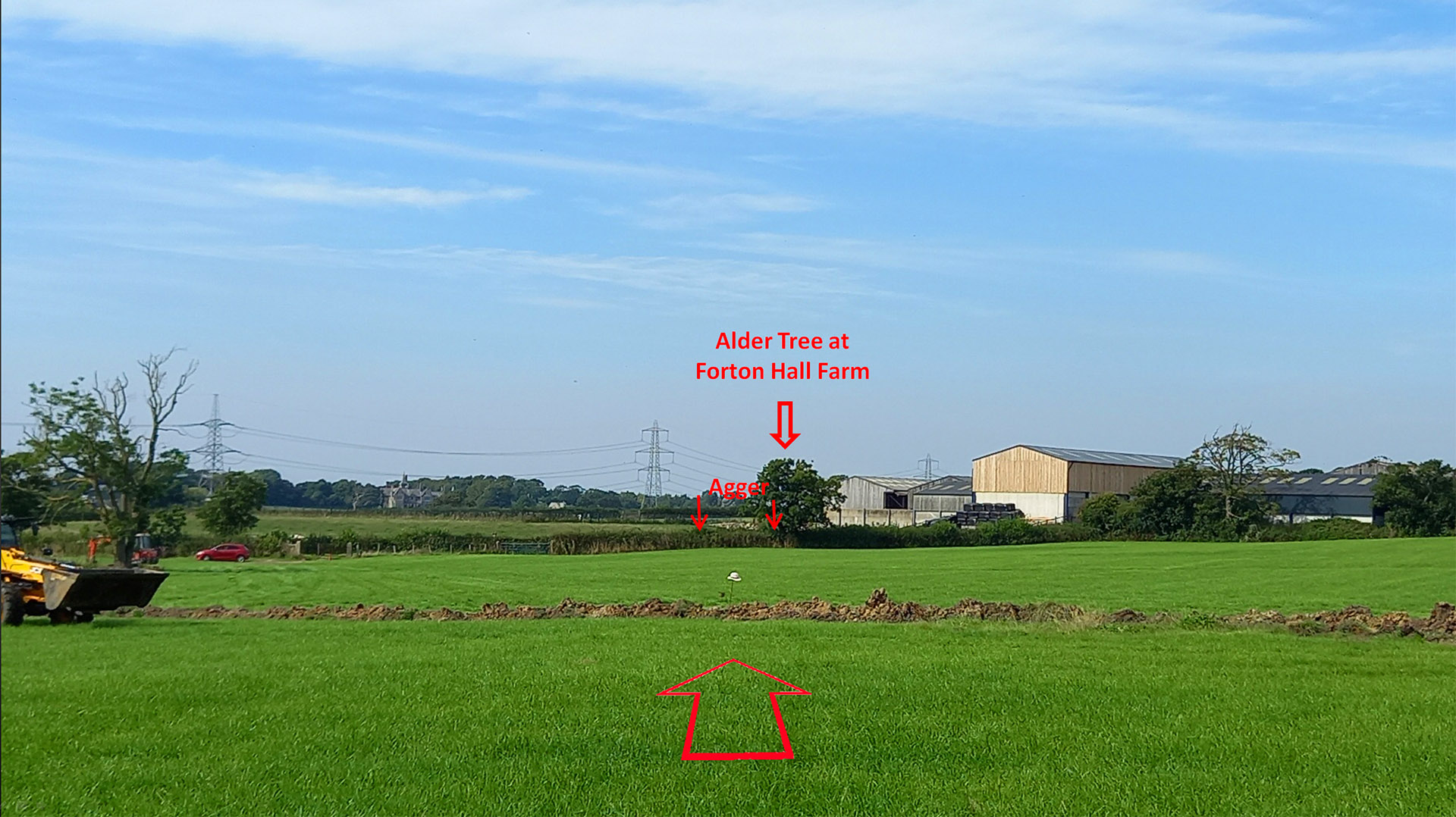
Hornby Farm Further along towards Forton then we (Andy Jackson and myself) were given permission to explore land owned by Hornby Farm. We are stood on the line of the road looking towards the famous Alder Tree (see later) at Forton Hall Farm. Andy spotted the digger which appeared to be cutting a trench across the road line. Image: DR |
Click for larger view |
 |
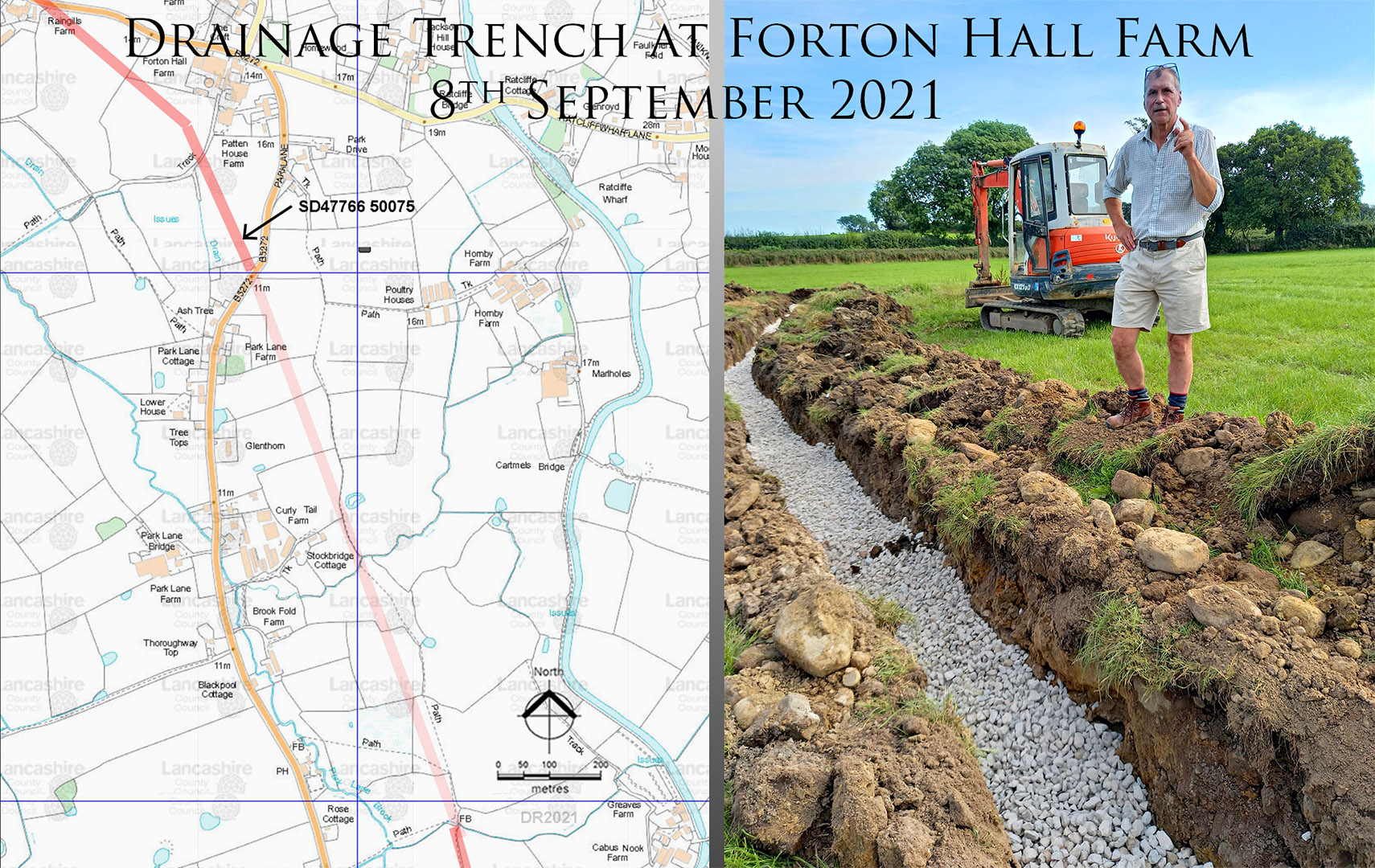
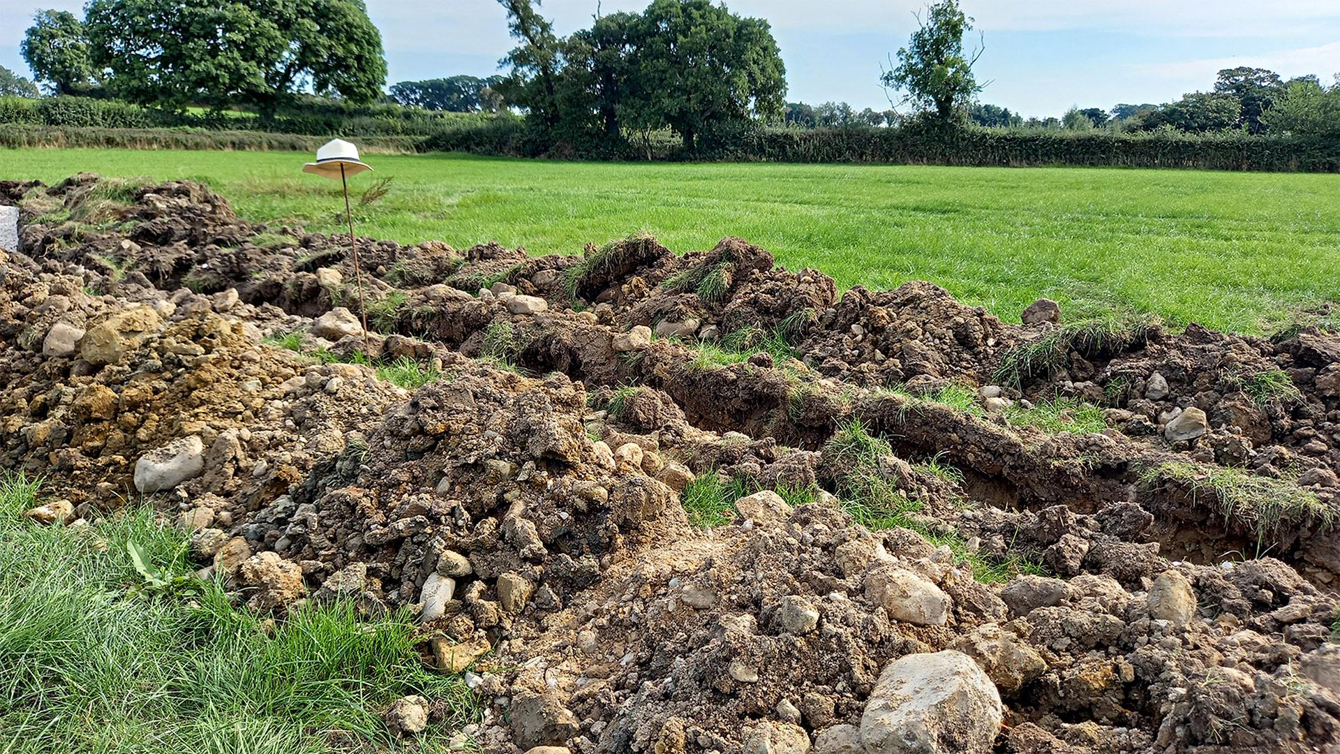
Drainage Trench across the Roman Road at Forton Hall Farm, 2021 Andy rang the farmer and got permission for us to go and witness what had been revealed by the drainage work. Andy ran virtually all the way and he was just in time to stop them filling it all in. I went back for the car and drove around to the site. Andy therefore beat me by 10 minutes to be the first person to see the Roman road for probably over 1000 years! Image: DR |
Click for larger view |
 |
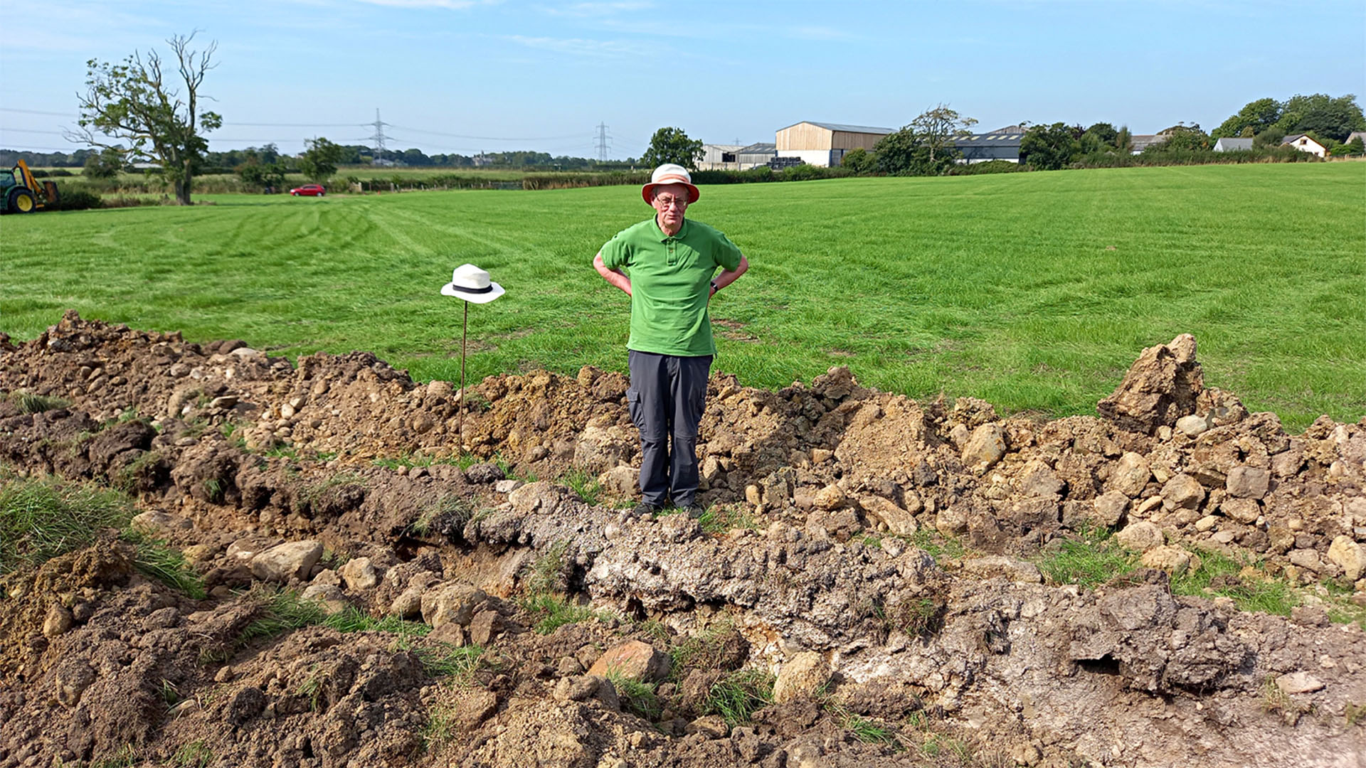
Road alignment crossing the excavation We are looking down the line of the Roman road towards that Alder Tree and the trench can be seen crossing the line. Andy's hat on a spike can be seen marking the centre of newly revealed road stones. Note the swell in the hedgeline left of the alder tree - the road agger. Image: DR |
Click for larger view |
 |
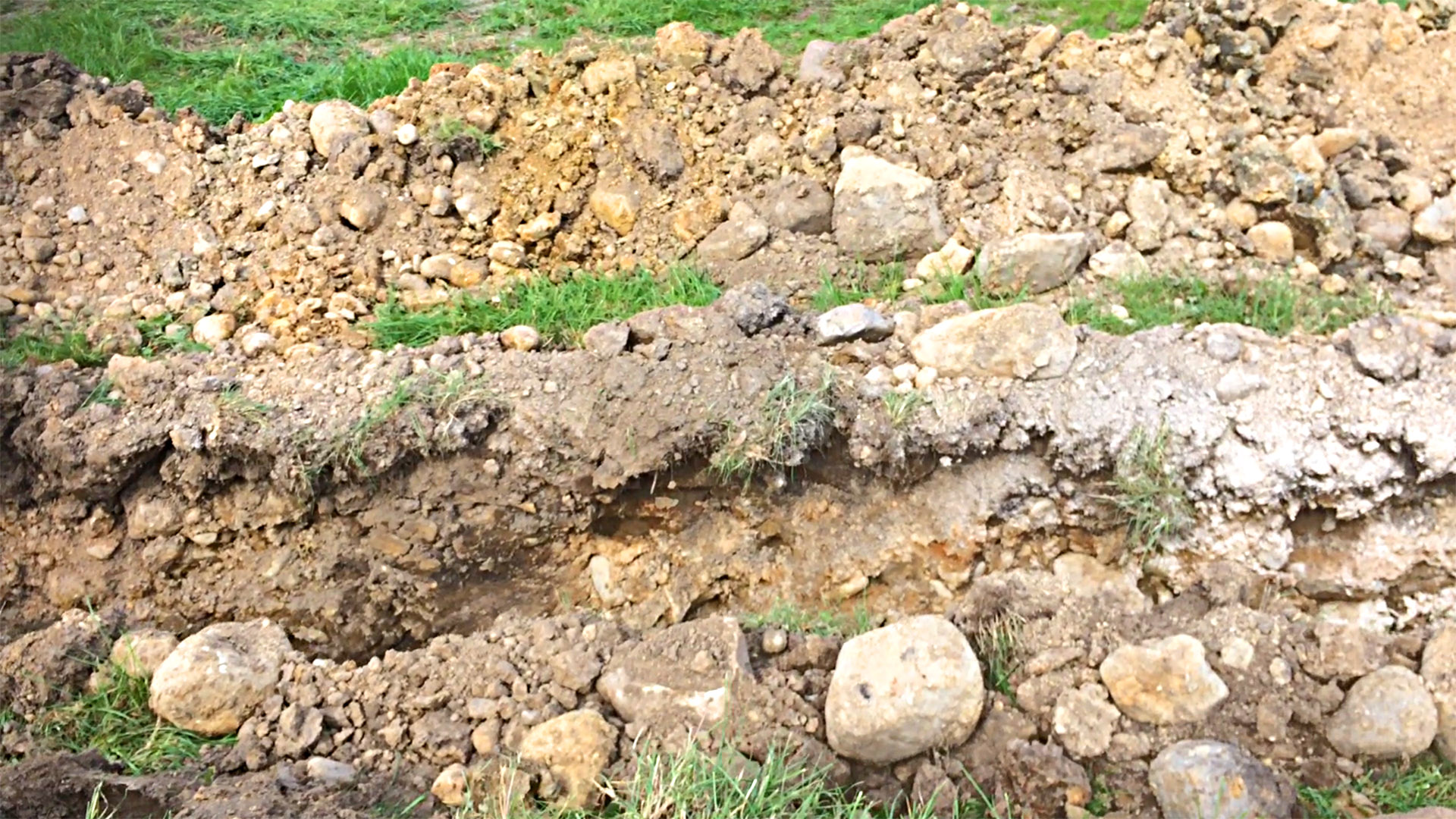
Stones from the Roman road Only on the line of the road were stones, and loads of them, evident stretching perhaps 8 to 10 metres wide. Away from the road there were virtually no stones. The excavated stones were rounded and large, presumably from the River Wyre over a mile and a half away to the east. Image: DR |
Click for larger view |
 |
Trench Close-up The archaeology was just about destroyed and the bottom of the trench had already been filled in with gravel. However, traces of the road construction layers are just about evident. The ditches could not be seen - we assumed they must have been covered by the gravel infill. Image: Andy Jackson |
Click for larger view |
 |
Edge of the Road Notice how the stones stop abruptly by the bag marking the edge of the road. Image: Andy Jackson |
Click for larger view |
 |
Surrounded by Roman road stones! Apologies for looking smug - it was actually more relief than smugness! There can be no doubters now - this is the Roman road and it heads to Cockerham! Image: Andy Jackson |
Click for larger view |
 |
|
Video of the Excavation at Forton Hall Farm |
||
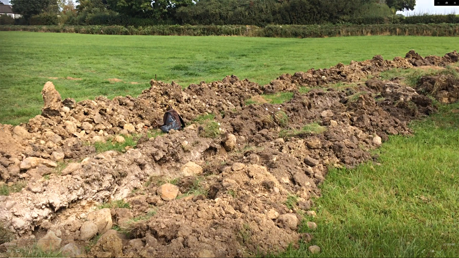
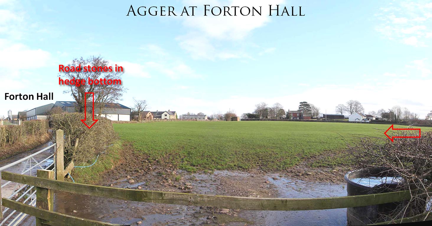
Agger at Forton Hall 2016 This was early 2016 and still winter. I had found the road using Lidar but is was not where it was supposed to be. This was the first concrete proof on the ground that the road was here heading for Cockerham not Galgate. This spot is close to the re-located milestone at Forton Cross Roads. We now know the route passes within about 200 metres of where is has been re-located (see below). Lidar shows the line of the agger at Forton Hall Farm and for once it was visible on the ground too next to that Alder Tree. The tree appears to have grown in the east ditch of the road.. To see this stretch park near the milestone and walk down the public footpath through the farm yard. Image: DR |
Click for larger view |
 |
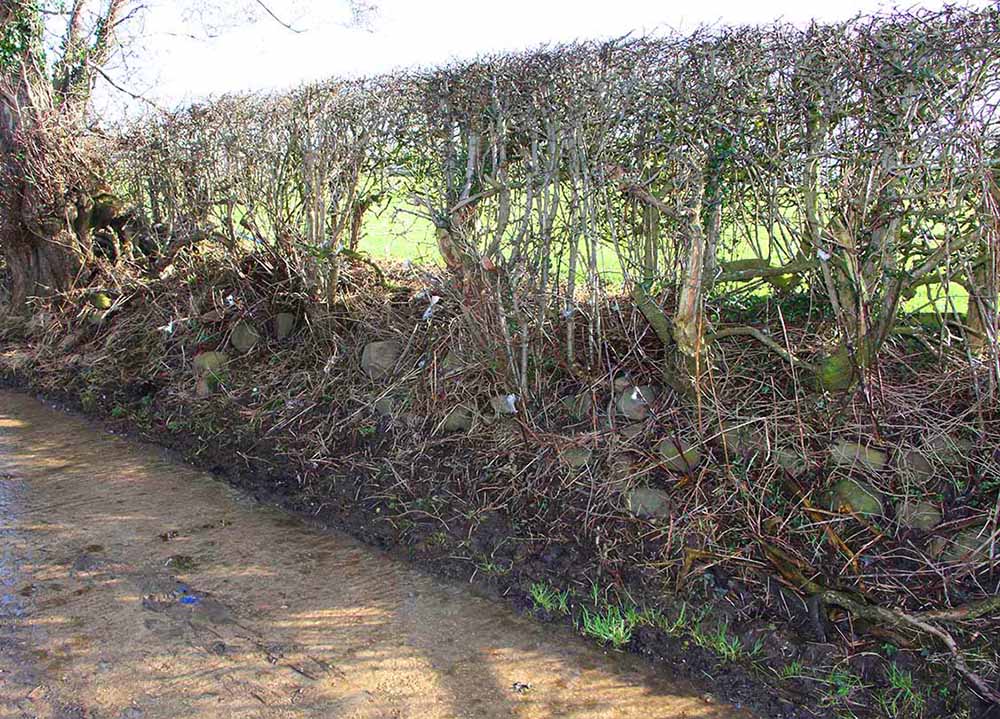
Roman Road foundation stones in hedge at Forton Hall The public footpath is along this farm track which appears to have been remade and concreted over. In the south hedge there are clear signs of the foundation stones of the road agger. There are no stones in the hedge away from where the road crosses - only where the agger shown in the above image reaches the hedge. Only visible in winter - the stones disappear in summer. Image: DR |
Click for larger view |
 |
3D Lidar Image - Roman road agger turning towards Cocker Bridge The turn at Forton Hall can be seen to be following dry ground and passes as close to what would have been marsh or even sea in Roman times. The line indicates it would have crossed the River Cocker at or very close to the modern bridge - crossing the "Goker" river as Leland called it..
|
Click for larger view |
 |
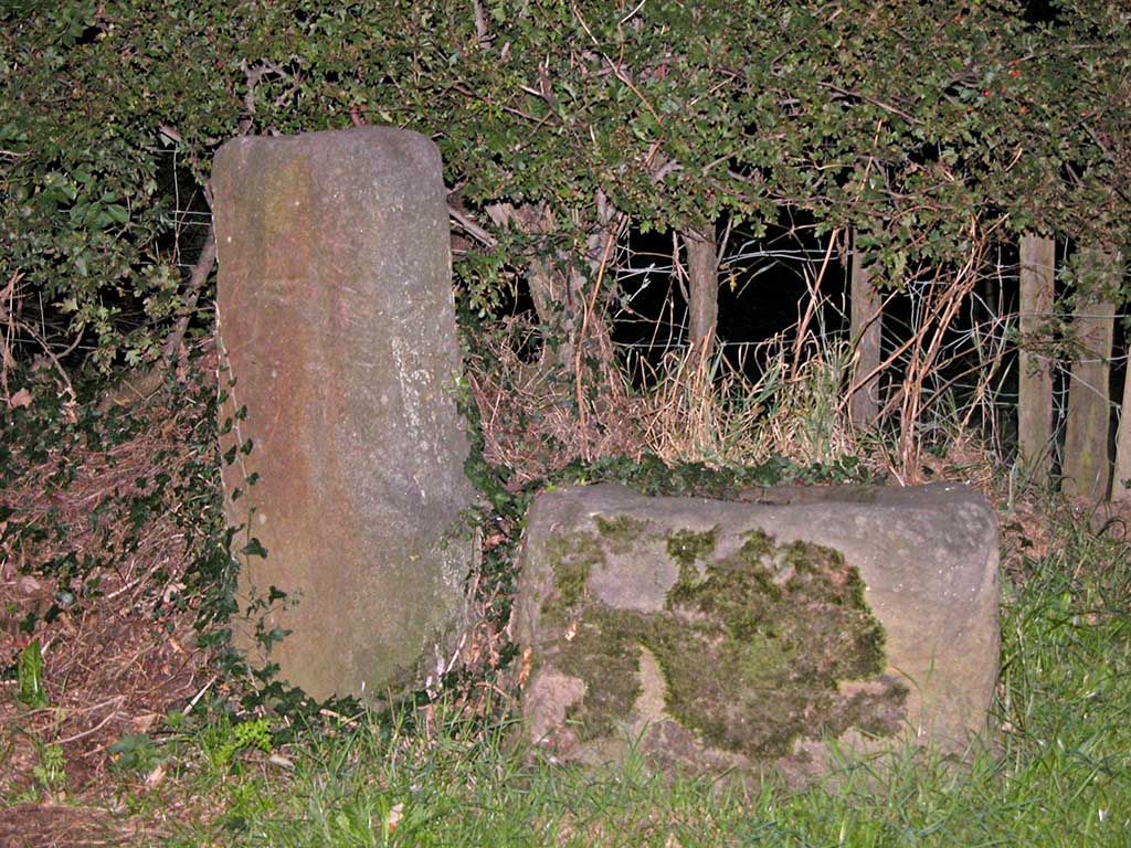
Forton Hall Milestone (re-erected at Forton Crossroads) The stump of a Roman milestone has been re-erected to Forton Crossroads next to a cross base. Its position now is 200 metres from the Roman road and if originally from Forton Hall then this is a relatively easy move to make in order to place it somewhere where it is clearly visible. Image: DR |
Click for larger view |
 |
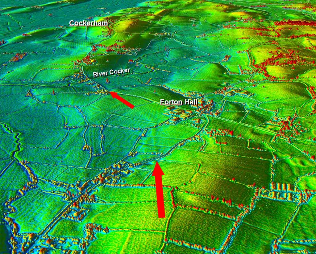
3D Lidar Image, Cockerham - looking North The modern road (Main Street) marks the approximate course of the road passing Wallings Ice Cream Cafe (recommended!) and heading on through Cockerham so finding traces is somewhat difficult. Projecting the alignment south from Lancaster (see later) would indicate that the Roman road must turn off the modern road and head for Lancaster somewhere near Broad Gate - surely a significant name. The colour scheme here has been set to show what was probably the sea in Roman times. All the land west of Cockerham is reclaimed with Hillam an island once. This fits with Leland's description of Cockerham "sandes". The road would therefore have made a coastal connection here.
|
Click for larger view |
 |
Broadgate to Thurnham Woods Between Broadgate and Thurnham Woods lidar indicates the road must have been ploughed out. However, thanks to on-site investigations, Andy Jackson has spotted several cluse that confirm the line of the road on this section. Images: Andy Jackson |
Click for larger view |
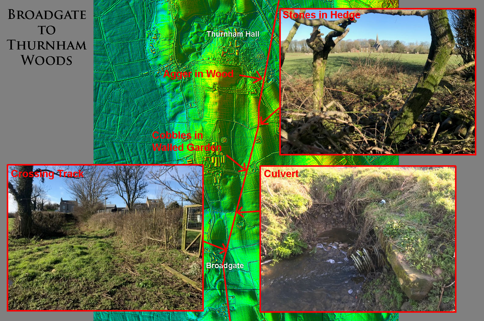 |
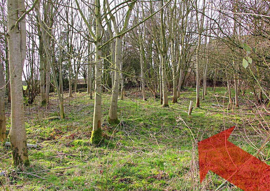
Agger in woods opposite Thurnham RC Church After the turn for Lancaster at or near Broad Gate then the next visible agger is in the woods at Thurnham RC Church (SD46615433). It is in remarkable condition probably as good as anything on the whole length. There are further lengths of the agger through the wood but undergrowth makes access, and photography, difficult. Where the road emerges from the wood there is a definite scatter of stones. There is parking at Thurnham RC church but the site is best visited in mid-winter. The woods are full of bluebells in spring and trampling in there to see the road wouldn't go down well. Image: DR |
Click for larger view |
 |
Lidar Image, Thurnham + Documentary Evidence Bill Shannon has discovered (2021) documentary evidence for the road at Thurnham. Bill wrote: "I was reading the charters of Cockersand Abbey in Dugdale's Monasticon Anglicanum (1846 edn, vol 6 pt 2, p.909) when I came across an undated grant of land in Thurnham to the Hospital at Cockersand (which would date the grant prior to 1190, when it became an abbey). The relevant bit reads: scilicet illam totam terram per eundem pullam quod descendit de mossa in magnum pullum extra antiquam viam .[Namely, all that land by the same pool that descends from the moss into the great pool outside/beyond the ancient road]. The moss here will be Thurnham Moss. 'Pool' here probably means a slow moving stream, and 'the great pool' probably means the River Conder (although it could mean something like that large piece of water below Conder Green) - and the 'ancient road' must mean the visible signs of your Roman Road, perhaps in the vicinity of Bayley Bridge(?)" I would agree with Bill that Conder Green is most likely the great pool. The Conder was canalised, ie put is a new straight channel, to facilitate the canal but there are signs of several old depressions that cound the the other pool mentioned. Either way an ancient road prior to AD1190 can only be our Roman road. Thanks again are due to Bill. |
Click for larger view |
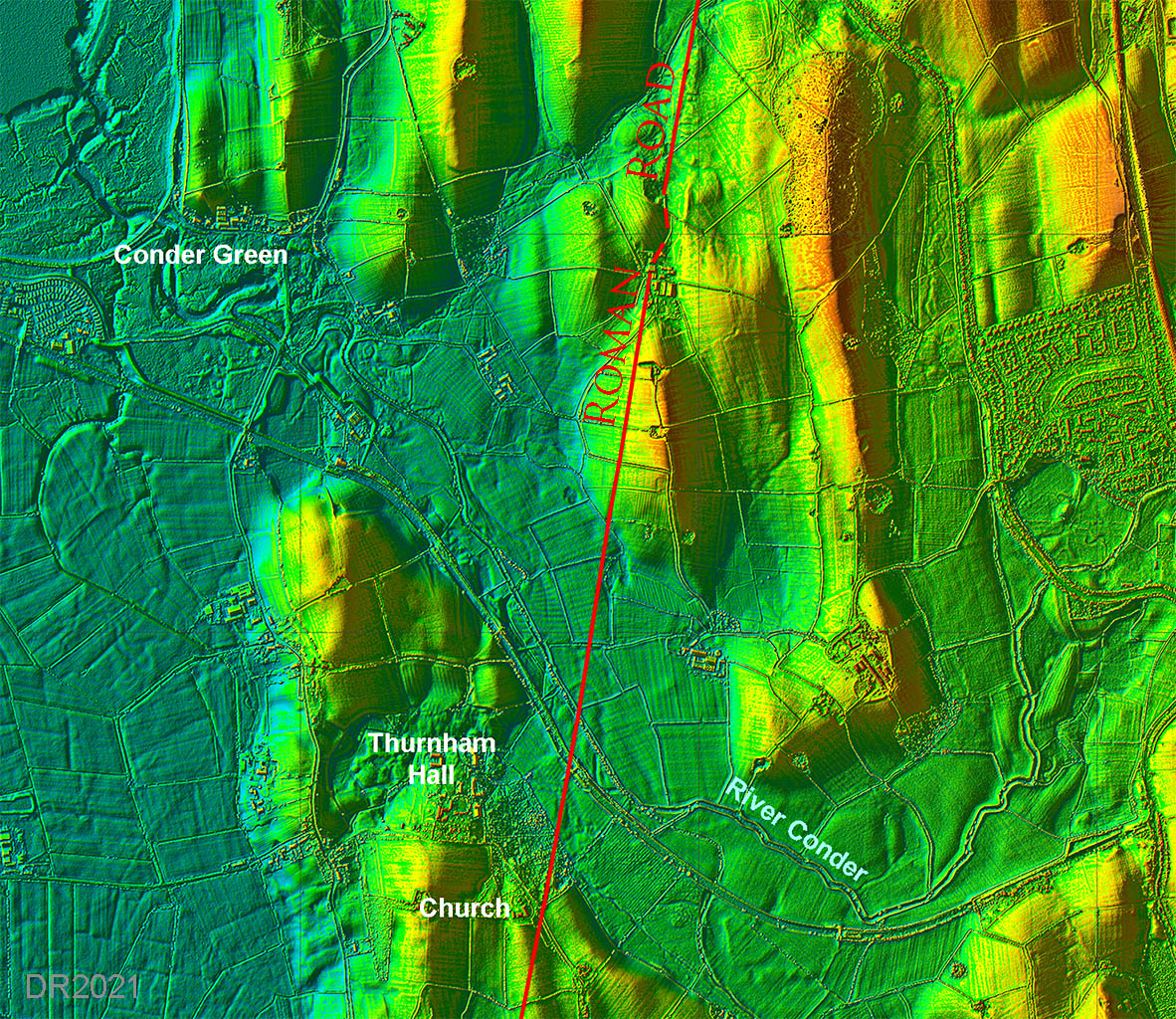 |
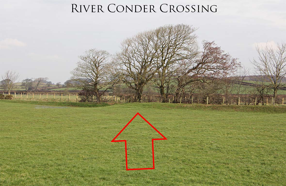
River Conder Crossing Either side of the new river course, on the line of the road, there is a swell in the ground. These mounds are visible in the Lidar image above and either are the remains of the agger or perhaps indicate that when they cut the new river channel there was plenty of road stones to dump. Either way they confirm the line. Image: DR |
Click for larger view |
 |
Lidar and Map - Ashton The agger at Ashton was the first one I spotted but I could not believe what I was seeing - the road should not have been heading towards Cockerham. All published wisdom had stated the road went east of Burrow Heights heading due south for Galgate. Only when I realised the road coming north from Garstang was also heading for Cockerham did everything suddenly click into place. The evidence for this section is overwhelming. The lidar image (left) shows the road very clearly and is convincing enough on its own. In addition, in the field "adjoining the canal" at Ashton was found a milestone dedicated to the Emperor Philippus. This recorded a distance of 3 MP (miles) obviously from Lancaster. This all fits perfectly this road and definitely not with the previously assumed route east of Burrow Heights.
|
Click for larger view |
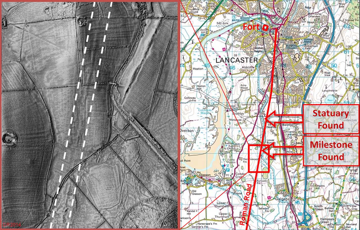 |
The Roman Road crossing the Mausoleum Field The evidence gets even stronger. Just north of this spot when excavating the canal in 1794 the famous collection of statuary was unearthed. These are taken to be from a cemetery and/or mausoleum which were commonly sited alongside roads. The find spot is given by Watkin as in the pasture "...on the east side of the canal and the south side of the lane leading from Broken Back Bridge". This locates the find field and the cemetery without any doubt. Attempts to "move" it to Burrow Heights so as to be next to the previously thought location of the road are groundless. The road and cemetery are on the west side of Burrow Heights. Note 1: the belief that the road ran east of Burrow Heights was partially based on aerial photography that seemed to show a straight feature heading for Galgate. Study of the Lidar data indicates that this is actually a glacial striation - a natural feature caused by ice movement and is not uncommon in our area. Note 2 -the name "Broken Back Bridge": the canal passing the field is in a huge deep cutting. It must have broken several navies backs digging it!
|
Click for larger view |
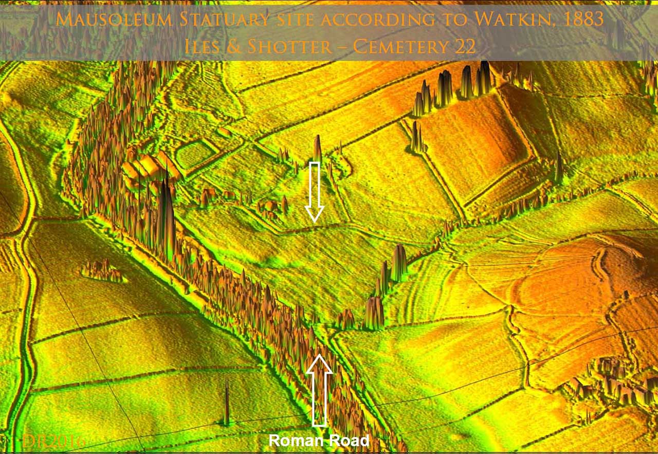 |
Mausoleum Field viewed from Burrow Heights Was the cemetery site chosen to be visible from Burrow Heights? Cemeteries were always alongside roads and outside settlement areas but it does seem a long way from Lancaster (2 miles plus). The nature of Burrow Heights is subject to much debate. Having walked all over the site and studied the Lidar of it and other "enclosures" and "hillforts" around the country then to me it does look like a small hillfort. Officially it is an enclosure. The location of the cemetery in full view of the "hillfort" would to some extant explain its location over 2 miles from Lancaster. Note: Burrow Heights and the cemetery field have been included as development (housing) areas in the proposed Bailrigg Garden Village by Lancaster City Council. They were designated without any inspection of the HER or consultation with the the Specialist Adviser for Archaeology for Lancashire. Image: DR |
Click for larger view |
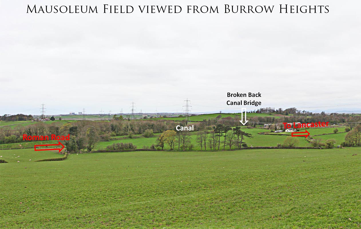 |
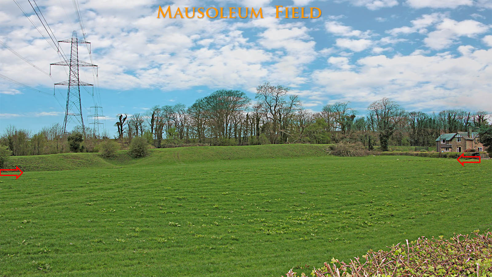
Mausoleum Field - Close-up View The road agger shows faintly across this field. This the find spot of the Statuary. The large mound beyond the road agger is spoil from excavating the canal by hand! No wonder they named the bridge "Broken Back Bridge"! Image: DR |
Click for larger view |
 |
Aldcliffe Road Rescue Excavation, Lancaster Heading into Lancaster, the traditional route is rejoined where the remains of the road were found at the Royal Albert Hospital and Ripley Heights. The alignment is not to the fort but along Penny Street and Cheapside. This was confirmed in 2005 with the discovery of the road (and a magnificent tombstone) on a development site just north of the canal at Aldcliffe Road (see right). Image: Peter Iles
|
Click for larger view |
 |
Detailed Route Map - Garstang to Lancaster We can at long last be certain of the route of the Roman road from Garstang to Lancaster. No doubt books and maps for several years to come will still show it heading through Galgate but we know better!
|
Click for larger view |
 |
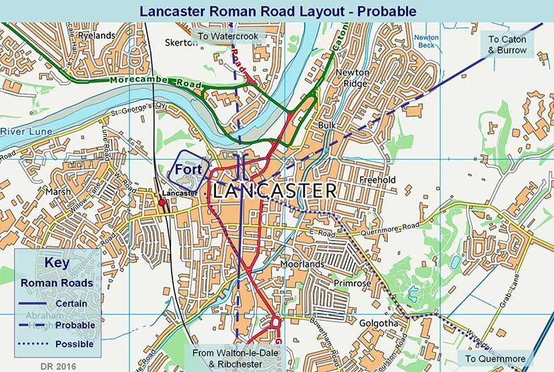
Lidar Image - Roman Roads of Lancaster The certain, probable and possible roads around Lancaster overlaid on a Lidar image..
|
Click for larger view |
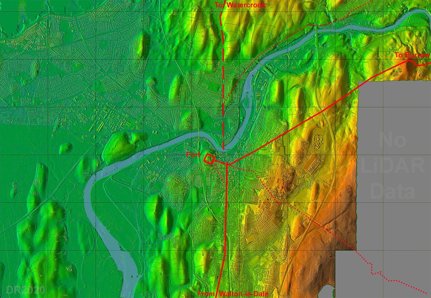 |
Roman Road Map Lancaster The location of the various Roman roads in Lancaster can now be inferred with high confidence. The position of the Lune Bridge would have been where the old river course was, south of the current one, and just to the east of the bus station. An area still prone to flooding today. To reach the fort from the road coming in from Walton-le-Dale then King Street almost certainly marks the line of a connecting road. |
Click for larger view |
 |
3D Lidar videos available for this road | ||
Section 1: Broughton to Catterall |
Section 2: Across Garstang |
Section 3: Cabus to Lancaster |
|
|
|
Last update: April 2025 |
© David Ratledge |