|
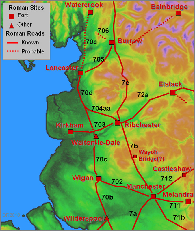
ReferencesA History of Communication In Lancashire, J M Whiteley BSc(Eng), C.Eng, MICE, FIHT former Deputy County Surveyor, Published 1984 in departmental magazine (Diversion). Ordnance Survey Map of Roman Britain - not up-to-date, has several omissions and errors but provides an overall picture. Ordnance Sheets of various scales and dates - extracts here are generally from the 6-inch First Edition of c.1845 available in Mario Roman Lancashire, W.T.Watkin 1883 (reprinted 1969) Roman Roads in Britain, Codrington, 1903/1918. (Bill Thayer's excellent online version - Chapter III covers Lancashire) A Roman Road North-West from Overborough, Villy in CWAAS, 1937 - Note Overborough = Burrow. Roman Roads in Britain, I.D. Margary, 1957. Still the best source but really needs updating. The "Margary" road numbers are from this book. A Lancashire Lion, J.L. Maxim, 1965 The Blackstone Edge “Roman” road thoroughly researched by a local historian. Romans in Lancashire, D.C.A.Shotter, Dalesman Paperback 1973. Roman Manchester, G.D.B.Jones/S.Grealey, Manchester Excavation Committee, 1973. Saddleworth 712, D. Haigh, Paperback 1982. Worth downloading and keeping! The Surviving Past, John Hallam (road excavation at Red Scar) Roman Fort and Town of Lancaster, Shotter and White, 1990, CNWRS Walking Roman Roads in Bowland, Philip Graystone, 1992, CNWRS Tameside before 1066, Michael Nevell, 1992, Tameside Metropolitan Borough Council The Dane's Pad (A Roman Road to Nowhere?), Ted Lightbown, 1996, The Blackpool & Fylde Historical Society. The Romans in Lunesdale, Shotter and White, 1995, CNWRS Walking Roman Roads in the Fylde and Ribble Valley, Philip Graystone, 1996, CNWRS Over-Wyre Historical Journal VII, Thompson (N), Lawrenson, Salisbury, Parkinson, Thompson (D), 1997 Romans and Britons in North-West England, David Shotter, 1993, 1997 and 2004, CNWRS. Now in its 3rd Edition and probably the best starter book. Edwards and Higham in "Leading the Way" - Ed. Alan Crosby, County Books, 1998. Ben Edwards on Roman Roads but don't miss Mary Higham's chapter which includes much Roman material too. Roman Forts on the Fylde, Howard-Davis and Buxton, 2000, CNWRS The Romans at Ribchester, Ben Edwards, 2000, CNWRS Walking Roman Roads in Lonsdale and the Eden Valley, Philip Graystone, 2002, CNWRS Journeys through Brigantia Volumes 2 and 11 , John and Phillip Dixon, Aussteiger The Roman Fort at Burrow in Lonsdale, Tony Burnett, Antonine Publications The Roman A65, Tony Burnett, Antonine Publications The Ancient History of Wyre, Harris and Hughes, 2006. Towards Watercrook: Indications of a Roman Road from Lancaster, Robert Entwistle, Contrebis VOL XXXII 2008-2009 Lancaster's Roman Cemeteries, Ed. Peter Iles & David Shotter, 2009. Roman Roads & Walls in Northern Britain, John Poulter, Amberley 2010. Discovering Coccium - the Archaeology of Roman Wigan, Ian Miller & Bill Aldridge, 2011, Oxford Archaeology (but ignore the Roman Road map of Lancashire!) Roman Roads & Walls in Northern Britain, John Poulter, 2010. Suggestions on how the roads were planned and set-out. The Secret History of the Roman Roads of Britain, M.C. Bishop, 2014. Excellent introduction and even answers the question how long would it take to build a road. Sites Explored, Lancashire, David Ratledge, Britannia 2015, 2016, 2017, 2018, 2019 Lancashire's Roman Roads, A Lidar Reassessment, David Ratledge, Lancashire & Cheshire Antiquarian Society Transactions Volume 110, 2017 Lancaster’s Roman Roads: A LiDAR Reappraisal, David Ratledge , Contrebis 2020 (Journal of the Lancaster Archaeological and Historical Society). Lancashire & Cheshire's Roman Roads, A Second Lidar Reassessment, David Ratledge, Lancashire & Cheshire Antiquarian Society Transactions Volume 112, 2020 CNWRS = formerly Centre for North-West Regional Studies. Now Regional Heritage Centre.
Useful Links Lancashire Old Maps This site amazingly escaped the LCC cull of historical web pages. Must be too popular! Mario The original and still the best source of Lancashire mapping and aerial photography both old and new. Huge amount of data. Roman Era Names Anthony Durham's excellent site regarding Roman site names. Local Societies active in Roman Road research Chorley Historical and Archaeological Society. Lancaster Archaeological and Historical Society Publisher of the journal Contrebis with many papers on our Roman Roads. Ribchester Local History Society Wigan Archaeological Society. Active group in the Wigan Area. Wyre Archaeology Possibly the most active group in our region.
Copyright, Developments and Contacts
CopyrightAll images and text here are copyright. However, copyright is highly complex! For example, raw Lidar images are copyright the Environment Agency but the processing is copyright David Ratledge. Images are copyright David Ratledge unless stated otherwise but can be used for non-commercial purposes providing recognition is given. Developments affecting Roman RoadsFor queries on developments that might affect Roman Roads please contact the relevant county HER custodian. These are listed for each road. Lancashire Contact MeIf I (David Ratledge) have missed anything, got it wrong or if you have any suggestions for improving these pages, please email
It is planned to update these pages on a 6 monthly cycle so if you have reported something please be patient. |
|
|
|
|
|
|
Last update: April 2018 |
© David Ratledge |