|
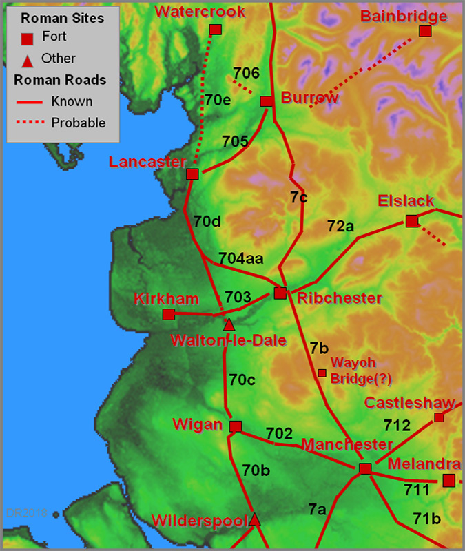
The Roman Road from Manchester to RibchesterMargary Number: 7bDistance: 26.5 milesConsidered by many to be the original Roman route north linking two of our most important forts. As we shall see below there was almost certainly an intermediate fort splitting the distance almost in two.
|
Historic County: Lancashire Current Counties: Greater Manchester & Lancashire HER: Greater Manchester & Lancashire
|
|
|
|
|
|
NEW 2023 -- 3D Lidar Video Flyover - Manchester to Ribchester - the full route
|
||
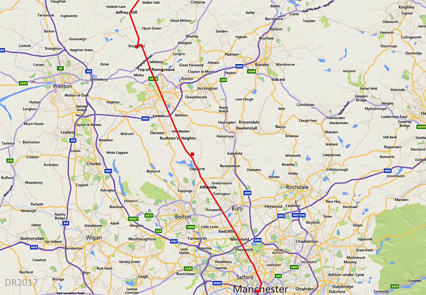
Lidar Image - Full Route A feature of the road is the use of long sighting alignments - indicative of military planning no doubt. The general alignment though clearly targetted the Edgworth Valley to get through the West Pennine Moors. Affetside was obviously a first key sighting point from Manchester although there is a subtle change of direction at Radcliffe. It has been claimed the alignment is on Lancaster but this seems illogical- Edgworth was the only sensible route to Ribchester and any long distant alignment would then be purely coincidental. The second alignment was on Rushton's Height but the actual road is rarely on it as it adapts the contours around Edgworth. The third is on the Top of Ramsgreave and the final one, not on Ribchester, but on Jeffrey Hill. The angular change of Top of Ramsgreave is only 1 degree so may just have been a limit of precision. |
Click for larger view
|
 |
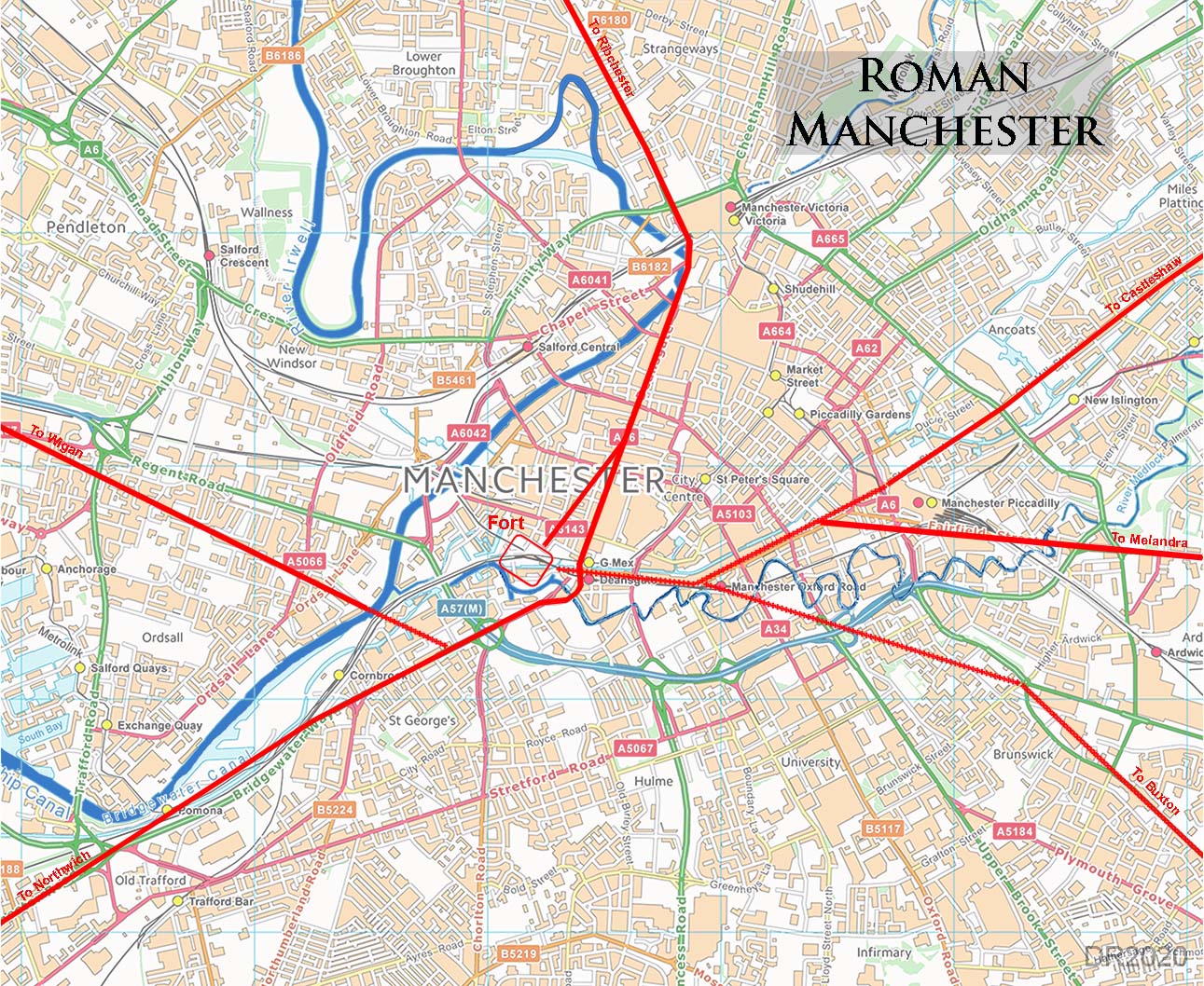
Roman Manchester Road Map A road issued from the north gate of the Manchester fort but this was more likely a connecting road to the main road which probably underlies Deansgate. The road from the fort made a shallow angle with Deansgate, the two coinciding around half way along, about where Lloyd Street is today. Deansgate was labeled "Roman Road" on the 1896 OS 25-inch map. At the north end of Deansgate, in the Cathedral area, the road swung around the River Irwell. The remaining route was remarkably direct based on inter visible high-points: The first was to Affetside (273 metres high) between Bolton and Bury. It was most likely sighted from Broom Hill at Higher Broughton at the Manchester end - see later. Sighting from Manchester or more accurately Salford, to Affetside might seem difficult today but would have been feasible in Roman times - no pollution or high rise apartments then. |
Click for larger view
|
 |
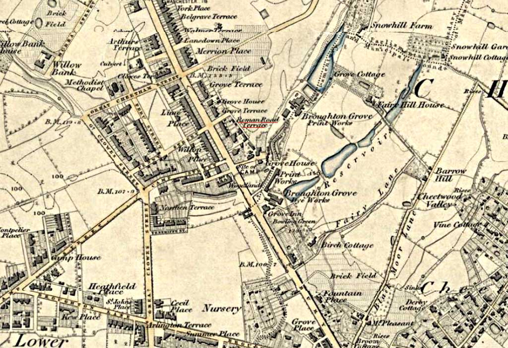
Ordnance Survey First Edition Map - Broughton On the first alignment parts of the modern highway (A56) represents the course and the former Roman Road Terrace provides the first clue!
|
Click for larger view |
 |
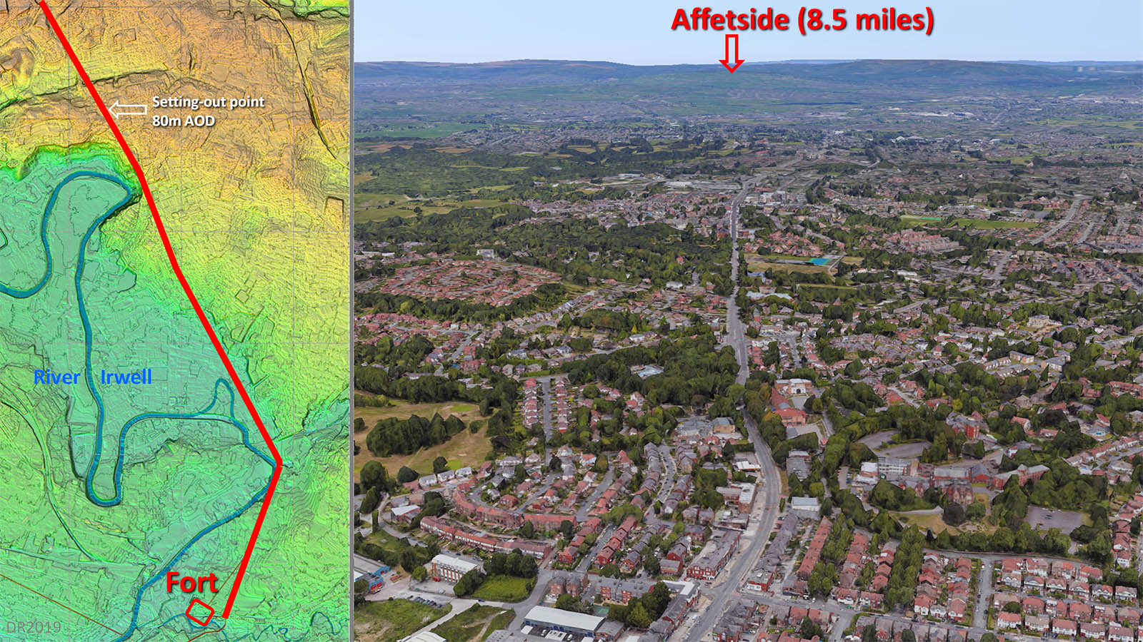
Contour and Lidar Map - Setting-Out position of the Affetside Alignment, Higher Broughton There was a subtle dog-leg to get around the loop in the River Irwell at Higher Broughton and this is where the straight alignment to Affetside really begins. However, it was clear from a study of ground heights that Singleton Road was the first practical point from which Affteside could be seen. This must have been the sighting point for an alignment of nearly 8.5 miles. In the left contour and lidar combination image the setting-out point is marked coinciding with Singleton Street today. This is the highest point around at 80 metres AOD. Right image is a GoogleEarth view.
|
Click for larger view |
 |
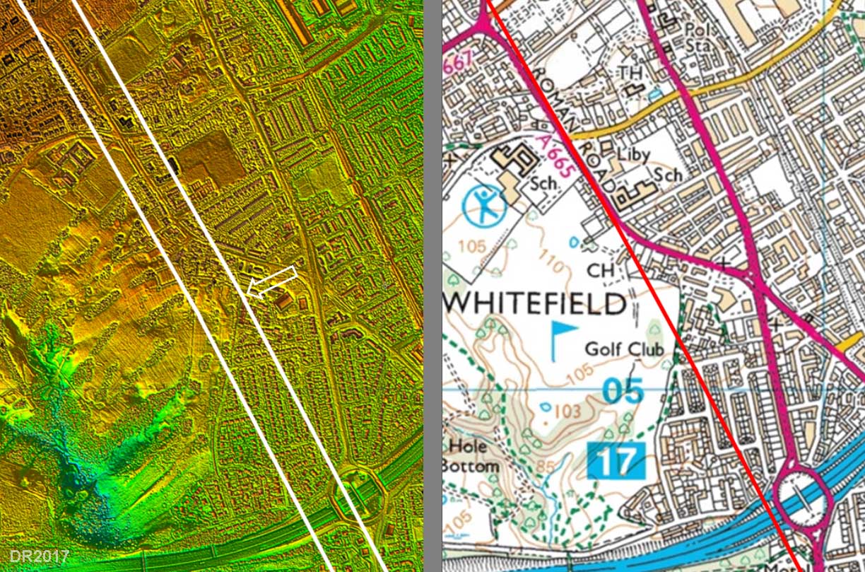
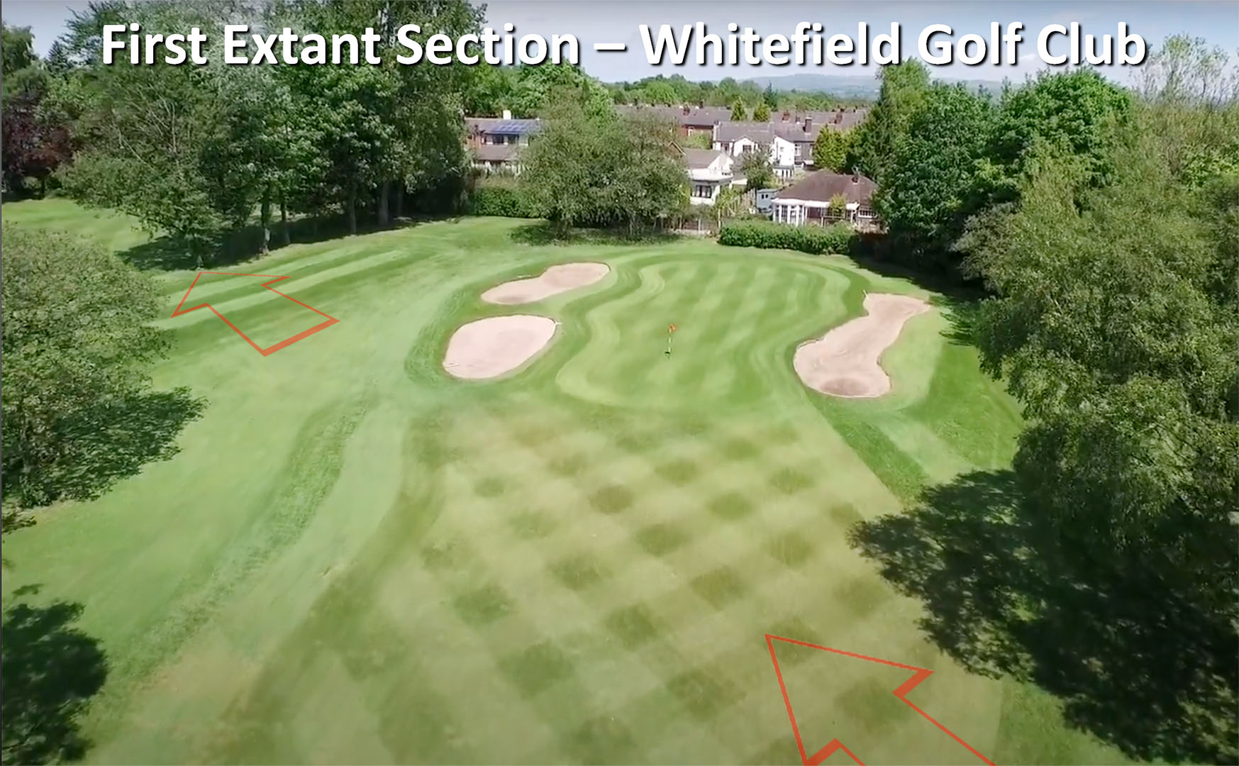
Lidar Image & Map - Whitefield Golf Club This appears to be the first extant stretch of the Roman road from Manchester. The agger has survived just in front of a green on Whitefield Golf Course. The line is a little to the east of where the OS first edition recorded it but now explains why trenching here by University of Manchester Archaeological Unit in 2008 did not find the road on the OS line. This was in connection of development of a parcel of land, formerly the site of the old clubhouse and putting green. The agger visible in the Lidar indicates the road was just east of the OS line and trenches. Thanks are due to Norman Redhead for this information. Paradoxically Bury New Road in places follows some of the the route. This seems to be the case of a turnpike road being built, at least in part, on Roman foundations. Bury Old Road is further to the east near Heaton Park and despite its name is not really therefore the older route. |
Click for larger view
|
 |
Whitefield Golf Course - Agger in front of 13th Green Obvious in the Lidar above but less so on the ground. Just a hint that he ground is parched a bit browner where the road agger runs. |
Click for larger view |
 |
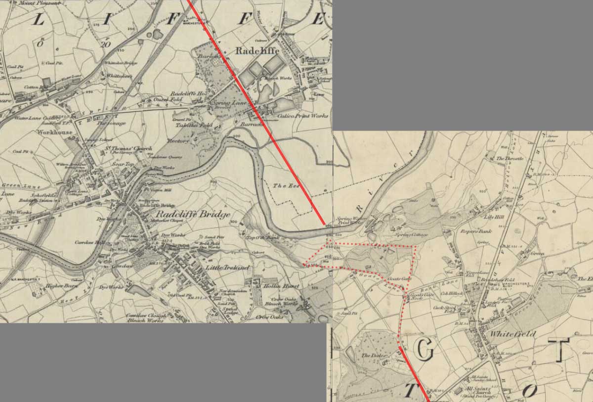
Crossing the River Irwell The Irwell at Radcliffe was the major obstacle on our road and it is likely it would have angled down to cross the river although the OS First Edition map indicates it carried straight on. This seems very unlikely given the steepness of the drop down so a dogleg via Goat's Gate is much more logical and typical. From studying 3D lidar models of this spot it appears there must have been landslips on the slope down to the Irwell so road remains here today are doubtful.
|
Click for larger view |
 |
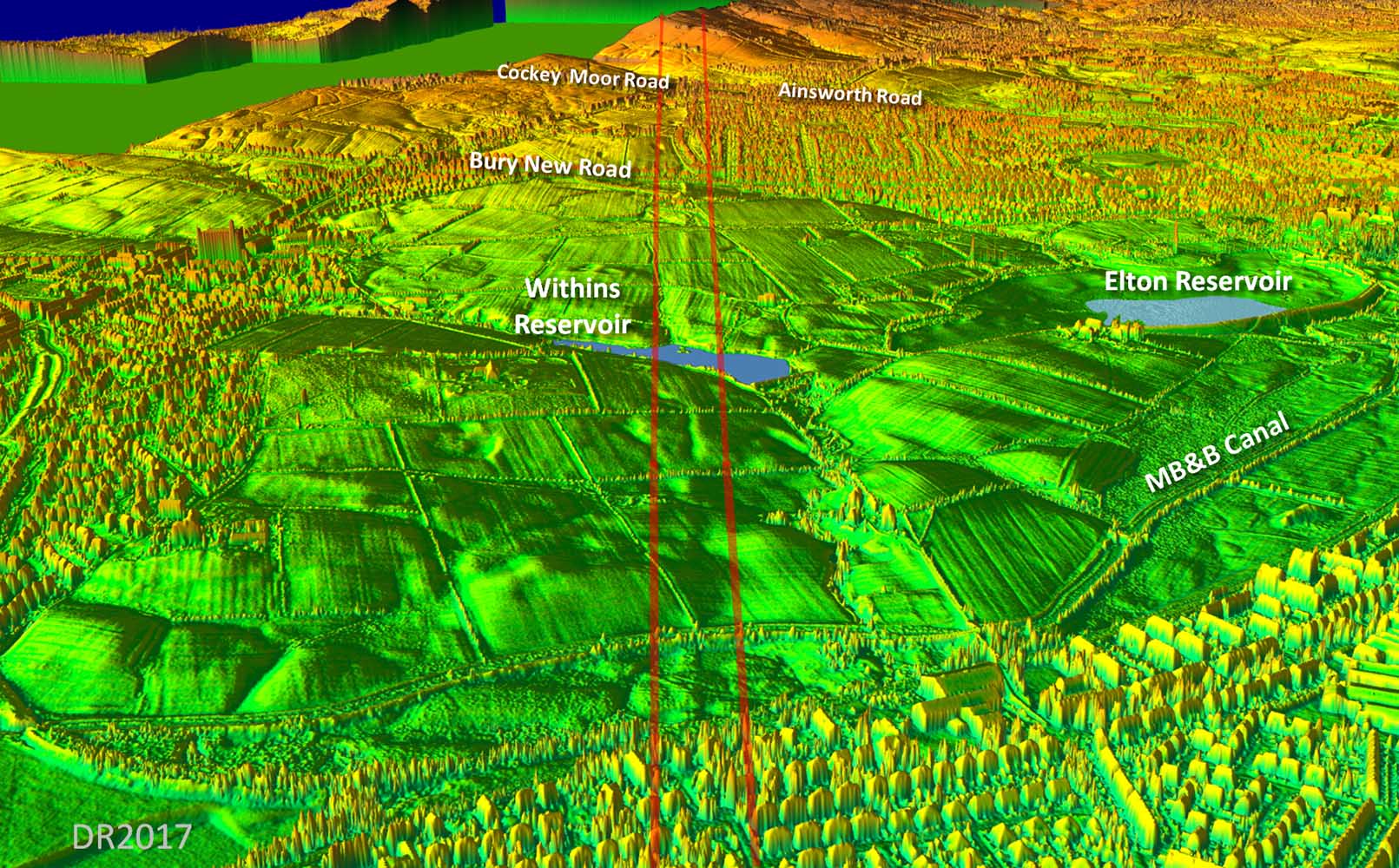
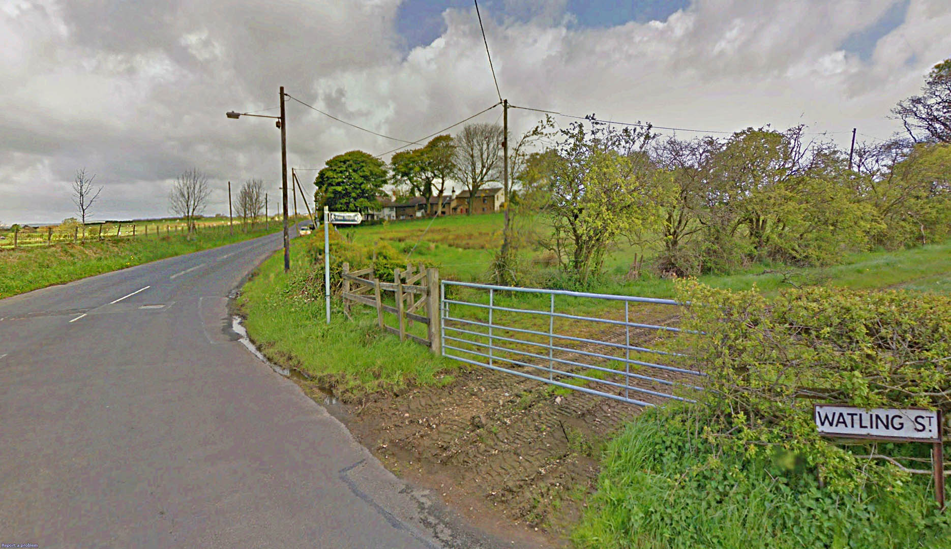
3D Oblique Lidar Image - Radcliffe The first long length of surviving agger begins north of Radcliffe either side of the Manchester, Bolton & Bury Canal and heads up towards Ainsworth via Withins Reservoir.. Between Bury New Road and Ainsworth Road there is modern housing with a street name Watling Street. It is though somewhat to the east of the real Roman road but at least the traditional name is preserved. Cockey Moor Road and Cockey Moor are names that for many years made this spot the leading contender for the location of Coccium. The Roman road can just be made out across Cockey Moor before the Lidar data runs out.
|
Click for larger view |
 |
Manchester to Affetside - Route Map At the high point of Affetside the first alignment ends and the road changes direction slightly to negotiate the Edgworth Valley. |
Click for larger view |
 |
Watling Street - Approaching Affetside This is the start of the road up and through Affetside - aptly named Watling Street. There are of many Roman roads that have that name attached but of course we have no knowledge of what the Roman's called them. |
Click for larger view |
 |
Oblique Lidar image - Affetside looking north Just north of Affetside the modern road wanders off line to the west leaving the Roman agger clearly visible so it looks to have survived well at this spot.. |
Click for larger view |
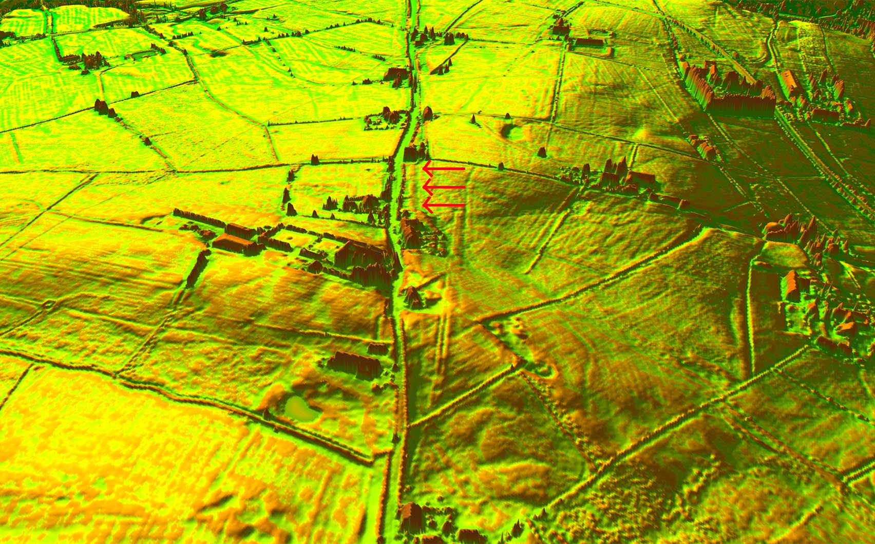 |
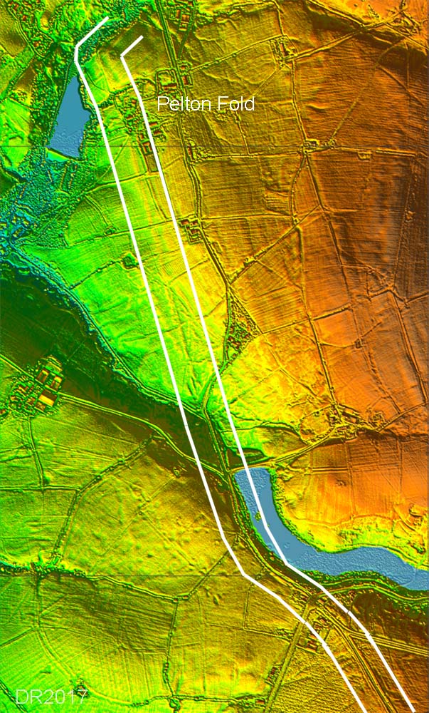
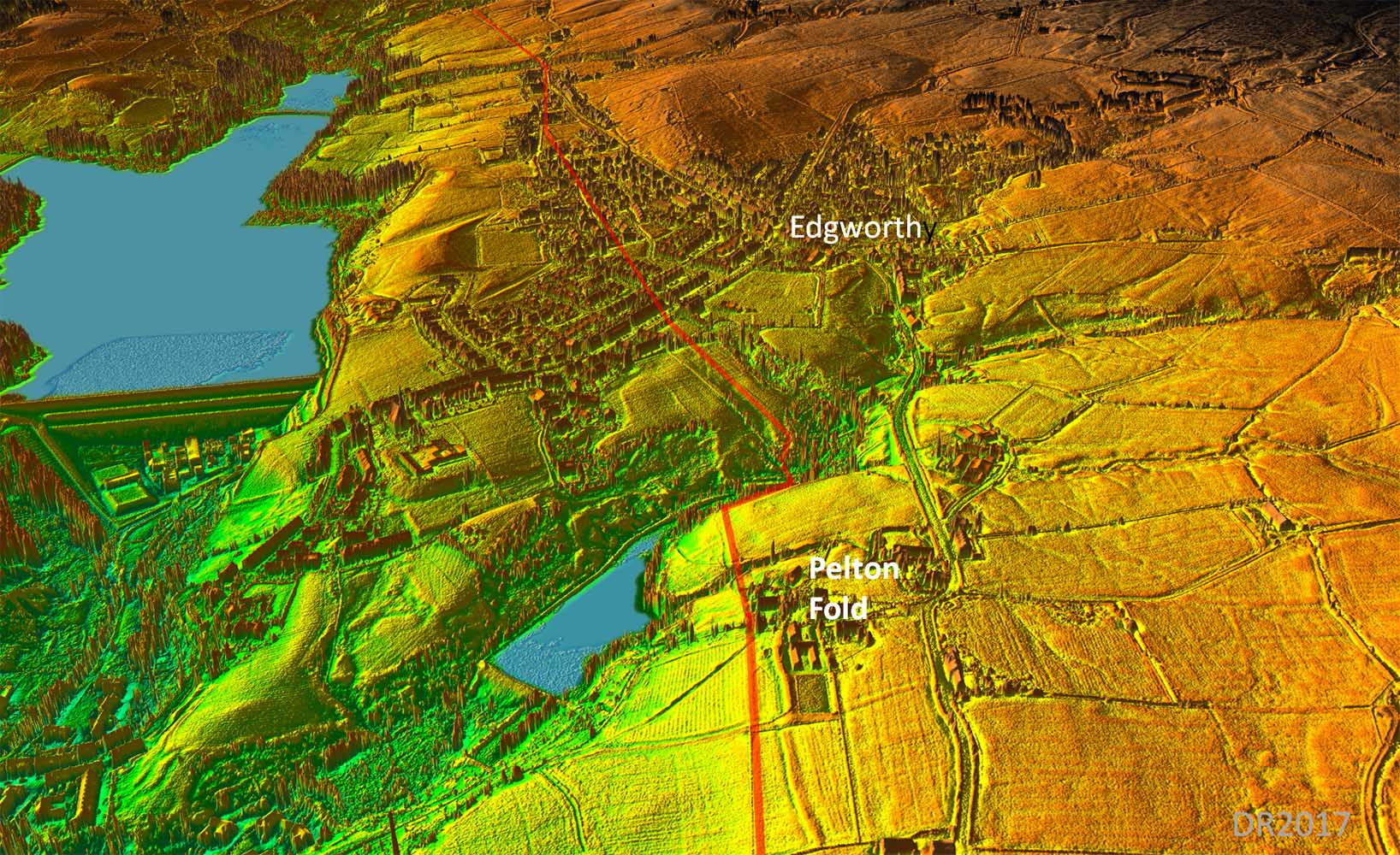
Lidar Image - agger leading to Pelton Fold This was the last definite stretch known approaching Pelton Fold before the Road was lost under Edgworth village. Lidar has extended beyond it beyond Pelton Fold dropping down to the cross Quarlton Brook near the modern footbridge. |
Click for larger view |
 |
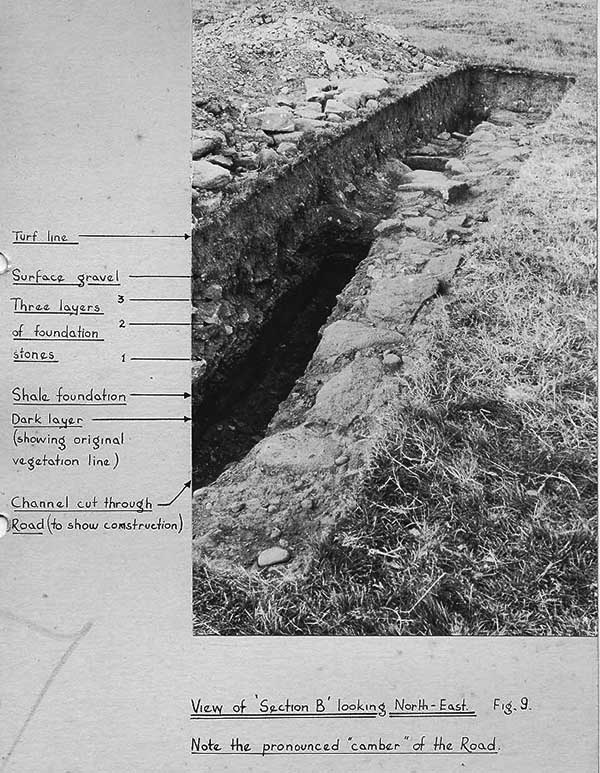
Roman Road Excavation 1950s - Knott's Brow (on the Pelton Fold stretch) - 1 In the 1950s, Chris Aspin led a group from the Helmshore LHS which excavated a section of the Manchester to Ribchester road to a field at Knott's Brow, near Edgworth. This is the length heading to Pelton Fold in the lidar image referred to above. Chris has kindly supplied copies of a cross section drawing and an annotated photograph. |
Click for larger view |
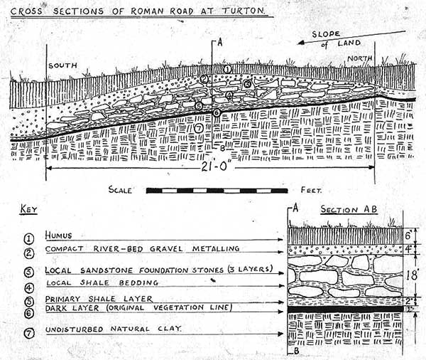 |
Roman Road Excavation 1950s - Knott's Brow (on the Pelton Fold stretch) - 2 As can be seen the agger was still prominently cambered in the middle. |
Click for larger view |
 |
3D Oblique Lidar Image - Edgworth There are signs of the road climbing up from Quarlton Brook. It then must then have passed close to the Barlow Institute and continued on via Horrocks Fold and slightly east of Horrocks Road north of this, before rejoining the main road heading for Hob Lane Bridge. |
Click for larger view |
 |
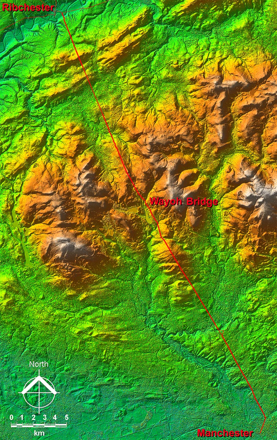
3D Oblique Lidar Image - Wayoh Bridge Fort Site Whilst searching for the course of the Manchester to Ribchester Roman road around Edgworth, I spotted the outline of a probable Roman fort at Wayoh Bridge. A check of various data sources revealed that ditches at this site had been recorded previously (1980s) and was logged in the PastScape database somewhat optimistically as Coccium, No. 44354. This referred to "The south-west and south-east sides of a probable ditched enclosure with rounded corner is visible on air photographs on one side of the Ribchester-Manchester Roman road.." It added " ....visited by Farrar in February 1981, who was unable to reach any positive conclusion about the earthworks." They didn't have Lidar then! |
Click for larger view |
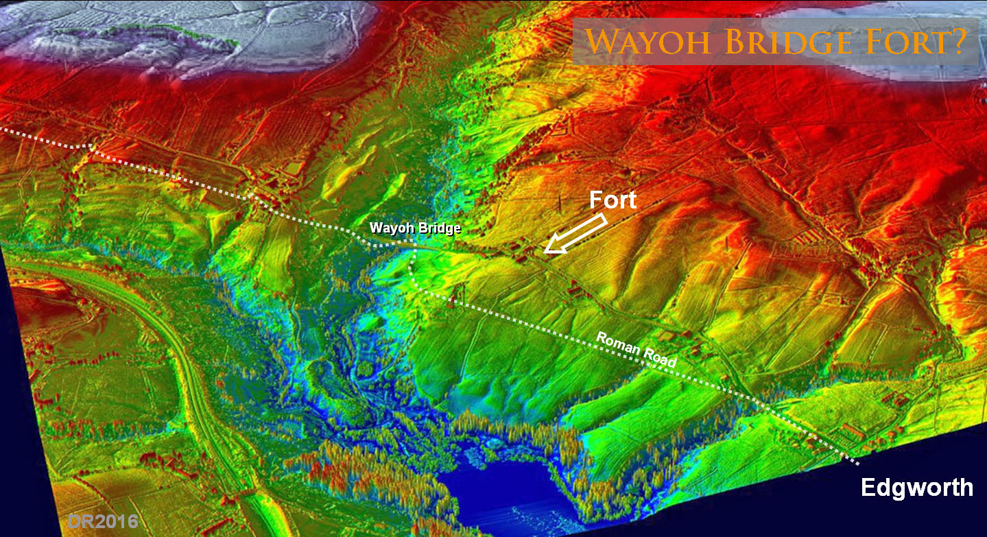 |
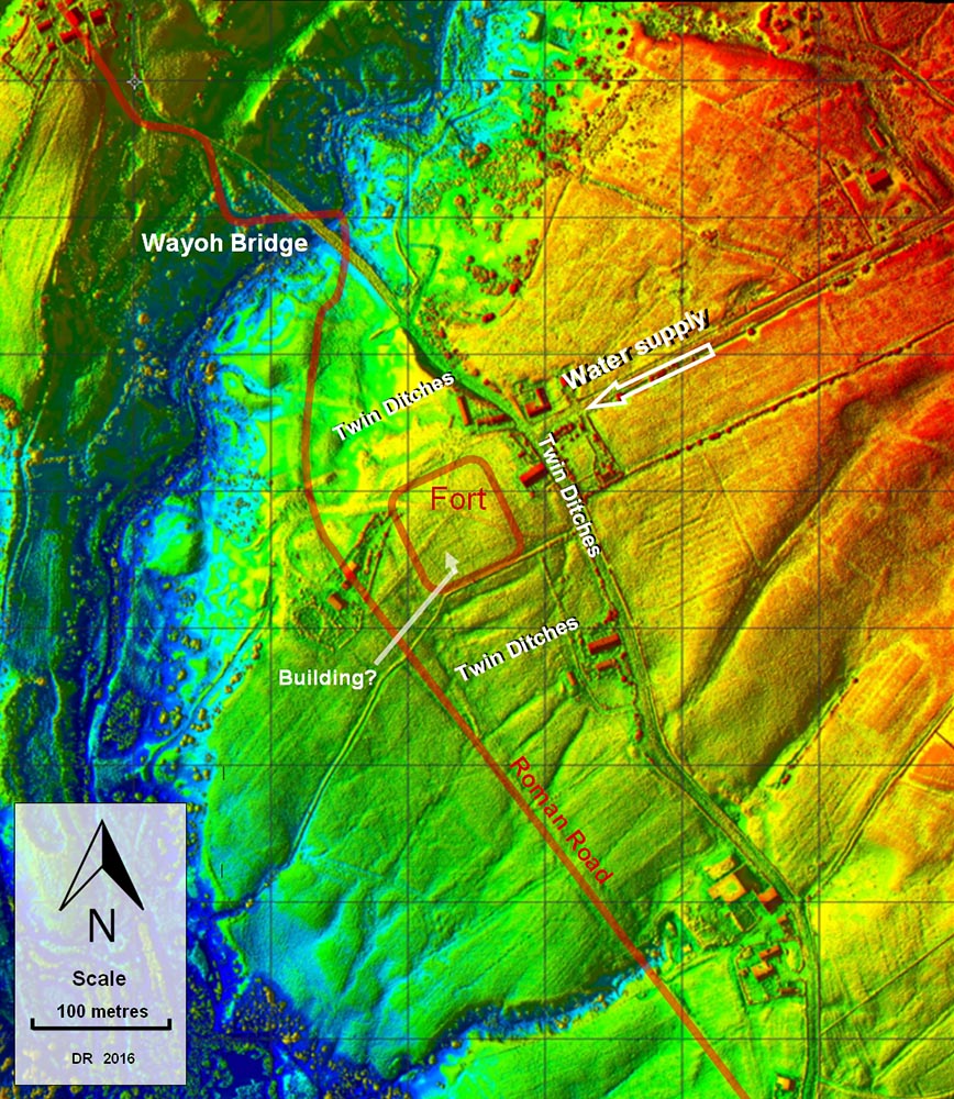
Lidar Plan - Wayoh Bridge Fort LiDAR has provided that positive conclusion and clearly visible is the probable outline of a small fort with double ditches on 3 sides, single ditch on the road side and 3 rounded corners. The Roman road from Manchester to Ribchester passes the fort on its south-west side and the fort's location on a headland before the descent to Wayoh Bridge is an excellent one. It has superb views both north and south along the Edgworth Valley. The site lies approximately 14 miles from Manchester and 12 miles from Ribchester making it a logical location. There are traces in the LiDAR data of an internal feature (building?) that respects the orientation of the fort. Also noticed was a water supply for the fort coming down alongside Moorside Road. |
Click for larger view |
 |
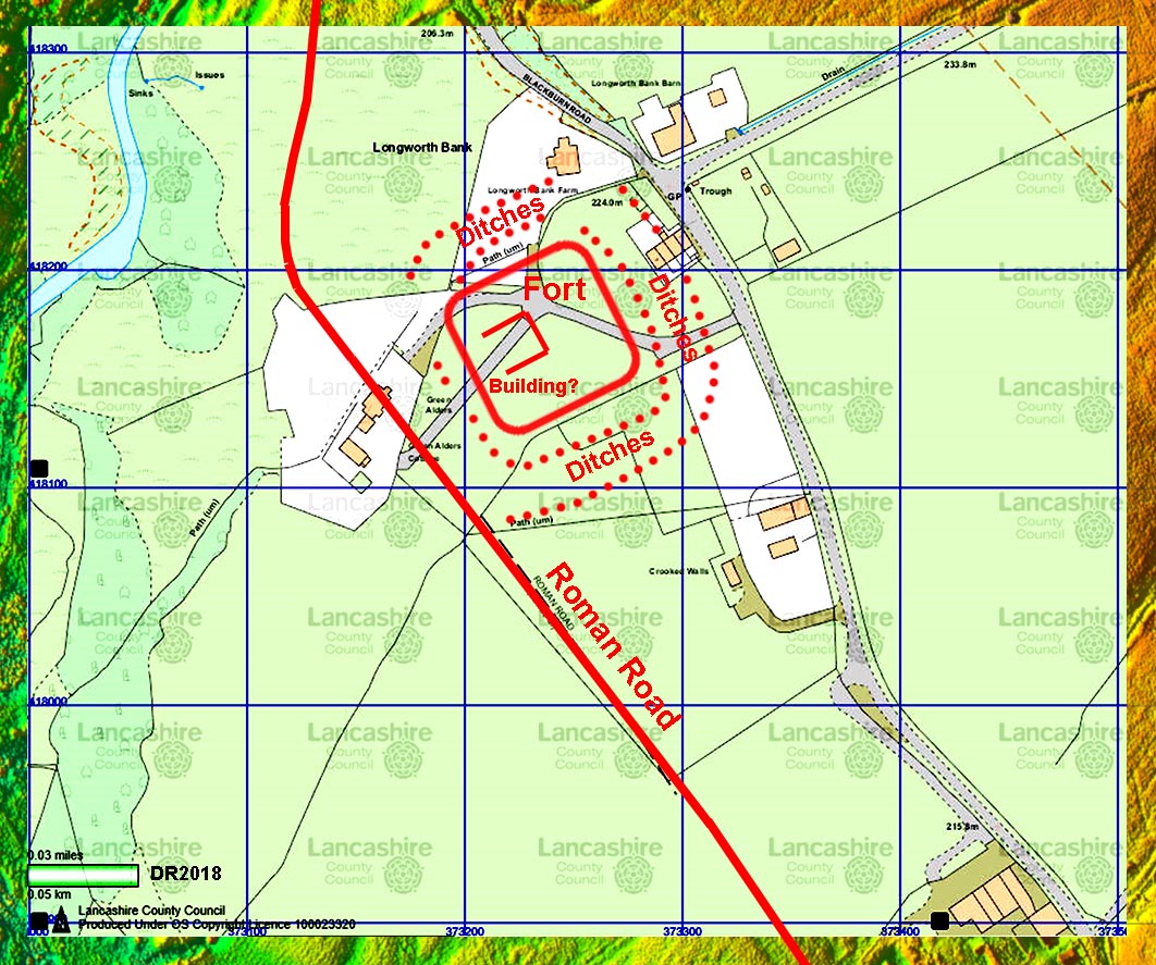
OS Map - Wayoh Bridge Fort The features visible in the Lidar have been transferred to the latest OS Map courtesy of Lancashire CC Mario
|
Click for larger view |
 |
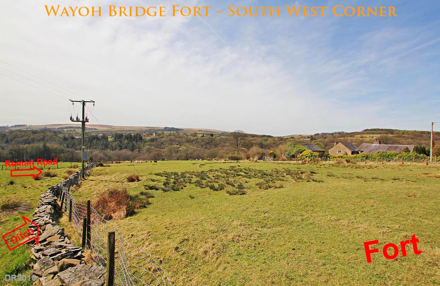
Wayoh Bridge Fort - South-West Corner Visits to the site have confirmed its suitability for a fort with the ditches evident and 3 of the rounded corners detectable. Often with LiDAR finding the features on the ground can be difficult but not here. The fort platform measures in the order of 75 metres square and could be described as either a fortlet or small fort. The double ditches are perhaps a bit unusual and could indicate two phases with a later reduction in size - possibly similar to Castleshaw which also lies at a very similar distance from Manchester (13 miles). There are traces in the LiDAR data of an internal feature (building?) that respects the orientation of the fort - see the LiDAR plan. Also noticed was a water supply for the fort coming down alongside Moorside Road.
|
Click for larger view |
 |
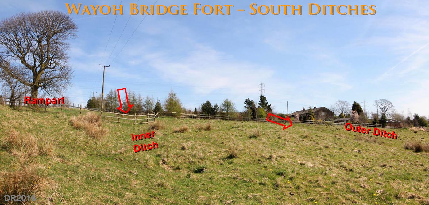
Wayoh Bridge Fort - Southern Ditches and Rampart The ditches on the south side are the easiest to find on the ground and the rise up to what must be the south rampart is even more obvious. The double ditches are perhaps a bit unusual as they are somewhat widely space. This could indicate two phases with a later reduction in size - possibly similar to Castleshaw which also lies at a very similar distance from Manchester (13 miles).
|
Click for larger view |
 |
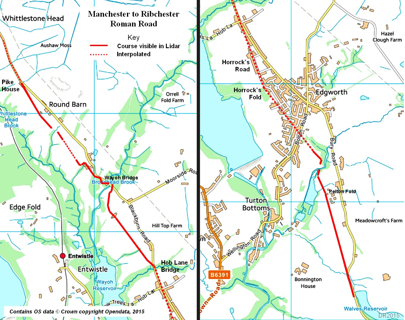
Roman Road Route Map - Walves Reservoir to Pike House Lidar shows the road continuing west of Blackburn road north of Wayoh Bridge before merging in the modern road at Pike House. |
Click for larger view |
 |
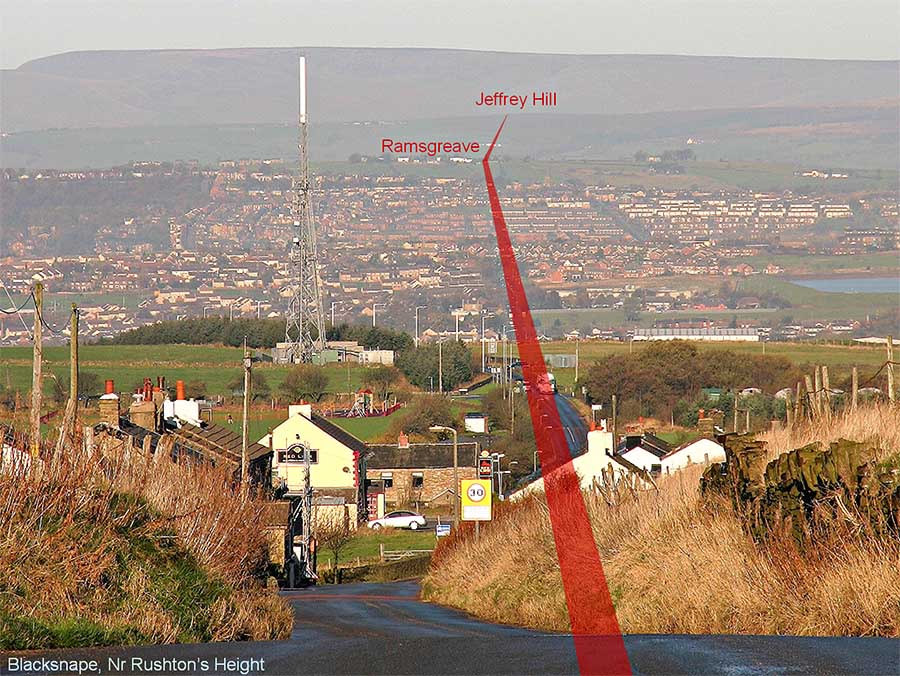
Blacksnape, Nr Rushtons Height - looking North It needs a very clear day to prove it but these long setting-out alignments were perfectly feasible. The final alignment change at Top of Ramsgreave is exaggerated in this telephoto shot - the actual angle change is only 1 degree for Jeffrey Hill. I have shown the line as straight on the photo but there is Lidar evidence that the Roman line could well be slightly further to the left (west) here on a line through the Red Lion Inn (cream gable ended building). There is a local folklore that the road is visible in the cellar. The Roman alignment leaves the modern Blackburn Road at Hoddlesden Road. In July 2005, Darwen Archaeological Society excavated to try and find the road at Brocklehead Farm but were unlucky. Lidar indicates the road is in the recorded position but has been much disturbed and removed in several places.
|
Click for larger view |
 |
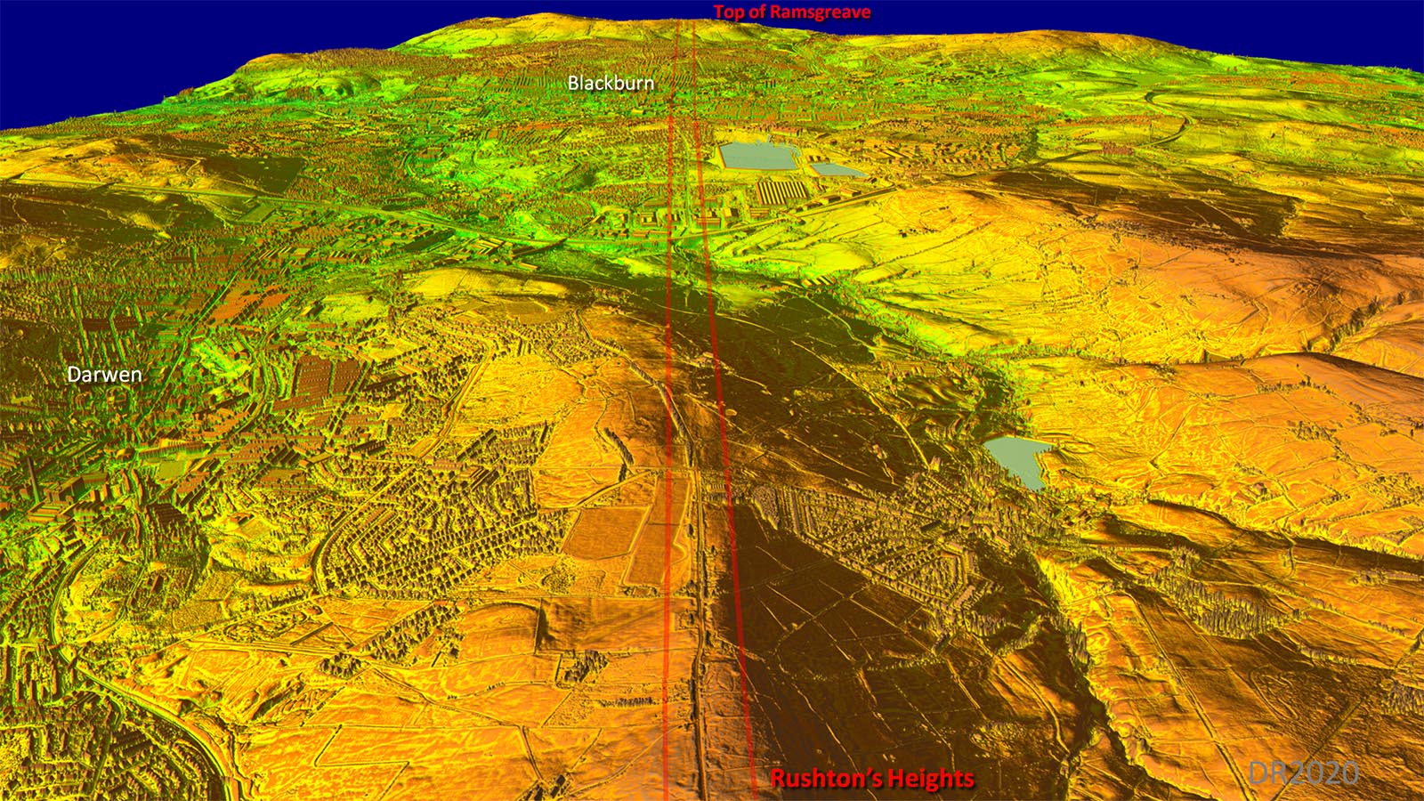
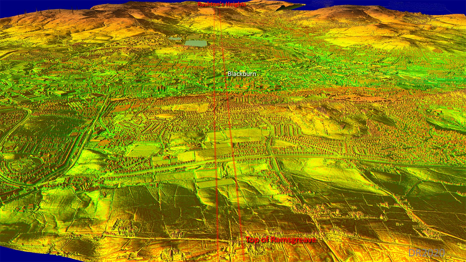
Oblique 3D Lidar Image - Rushton's Heights to Top of Ramsgreave The Lidar equivalent of the above view. From the higher viewpoint Blackburn becomes visible.
|
Click for larger view |
 |
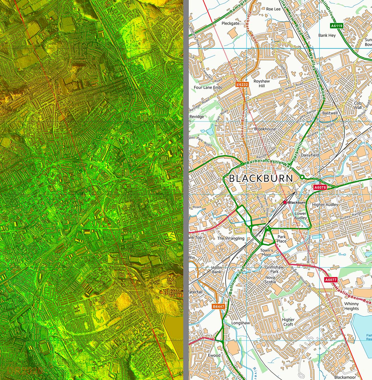
Lidar Image & Route Map - Blackburn Across Blackburn logically all we can do is interpolate. There does not seem to have been any evidence discovered over the years to pinpoint the alignment.
|
Click for larger view |
 |
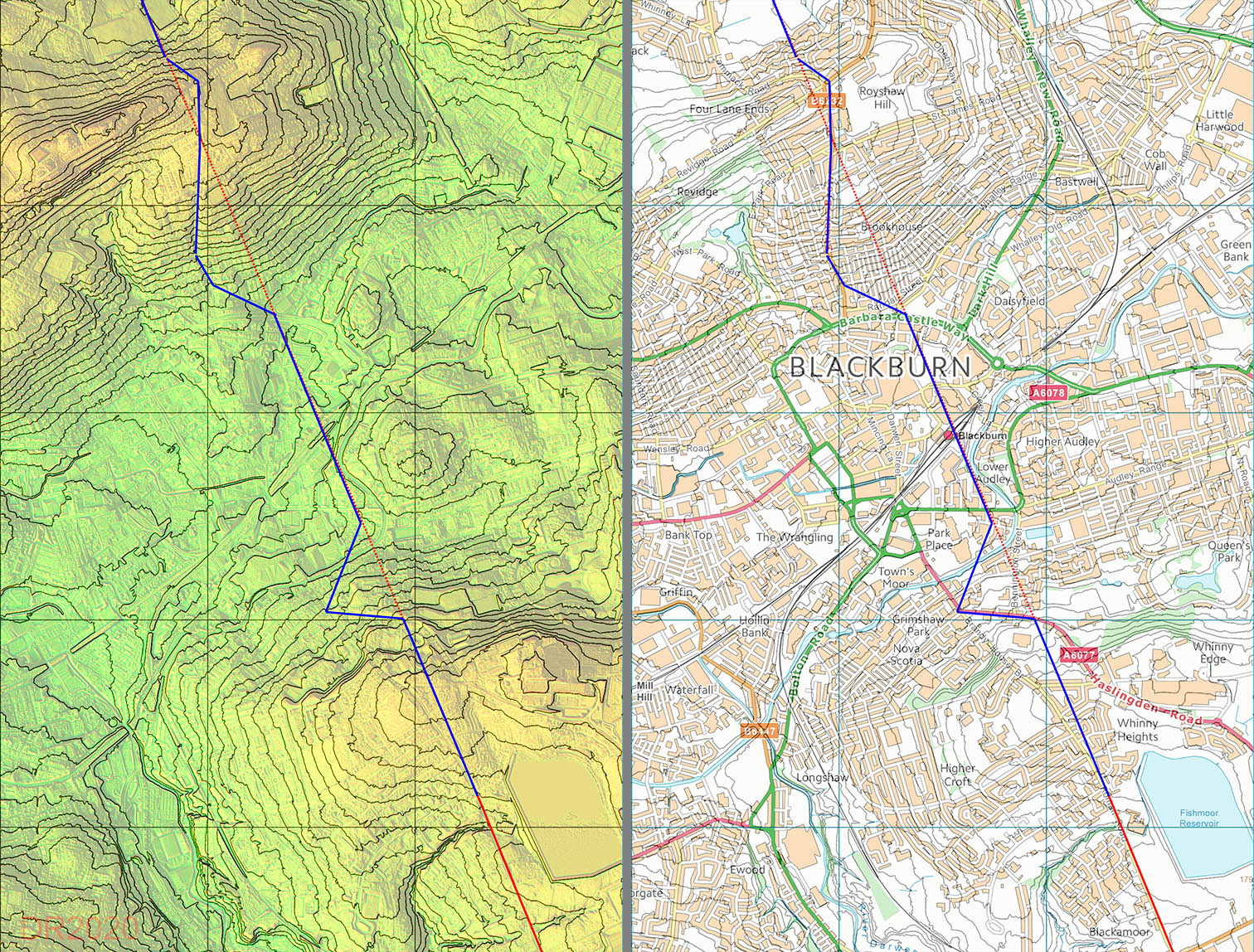
Blackburn Contour Map - Speculative Route Suggestions Blackburn is renowned for its hills. We can therefore expect the Roman road to have zig-zagged to negotiate the steeper gradients. The blue line is a best guess based what Roman engineers typically did in these circumstances. However, it is of course pure speculation. The contour map was generated from Series 2 DTM Lidar data.
|
Click for larger view |
 |
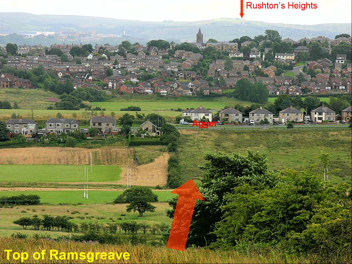
Top of Ramsgreave - looking South Looking back to where the Rushton's Height photo was taken. Blackburn lies out of sight over the hill with the church tower. This is the first visible trace north of Blackburn with agger showing as a lighter shade of grass. What also is evident is how big it is - this was a major Roman highway.
|
Click for larger view |
 |
Oblique 3D Lidar Image - Top of Ramsgreave back to Rushton's Heights The Lidar equivalent of the above view but from a much higher viewpoint.
|
Click for larger view |
 |
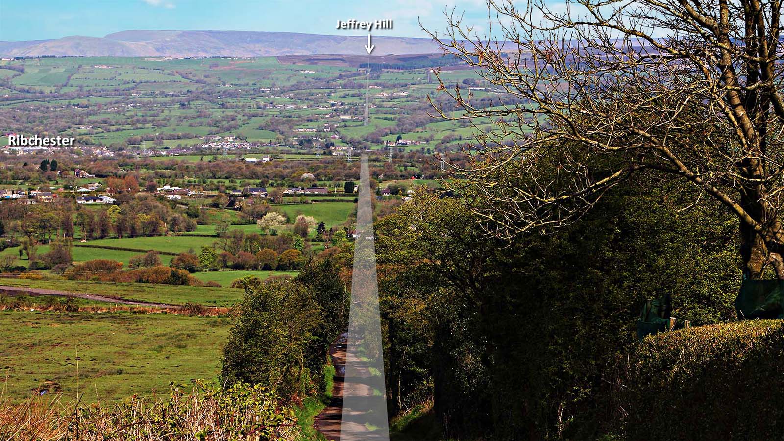
Top of Ramsgreave - looking North Ribchester fort is down in the valley bottom but the road is aligned on Jeffrey Hill. It can be made out by a series of hedgerows most of the way to Jeffrey Hill. The reason for the gap in the road overlaid on this image is that Ribchester was served by link roads and the straight on bit there was never a road (see below). Ribchester Note: Jeffrey Hill can also be spelt Jeffry. |
Click for larger view |
 |
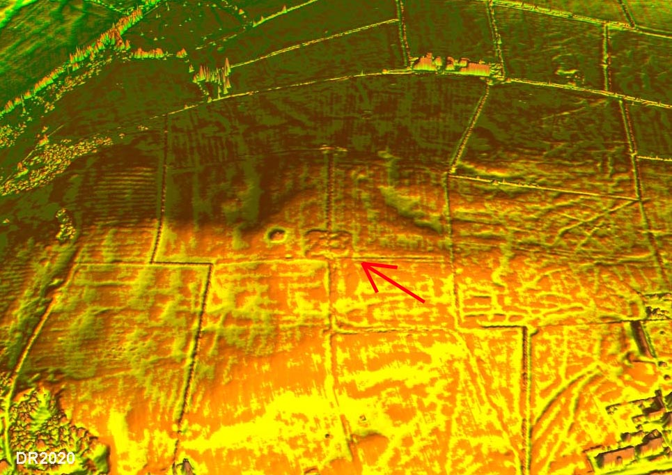
Oblique 3D Lidar Image - Mellor Hill On Mellor Hill, to the west of Ramsgreave, is the probable Roman watch tower. Lidar would seem to confirm this with a square enclosure with rounded corners and a possible square tower inside. This spot is intervisible with the fort. |
Click for larger view |
 |
Lidar Image - Roman Roads around Ribchester Ribchester was probably the most important road hub in Lancashire. After passing over Ramsgreave our road heads down to the Ribble valley and shares a common bridge with the road in from York - see later. |
Click for larger view |
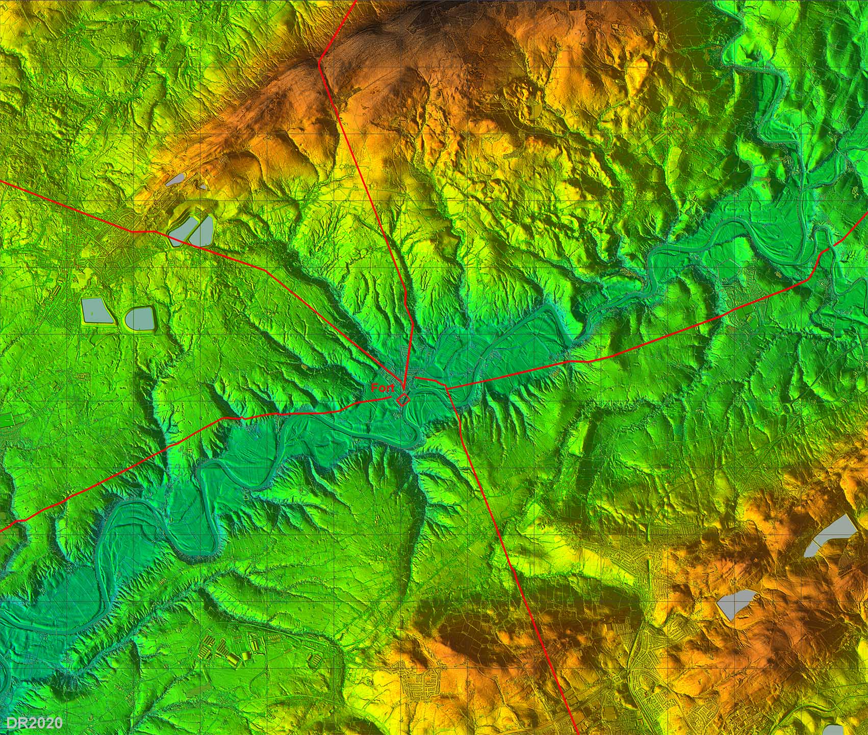 |
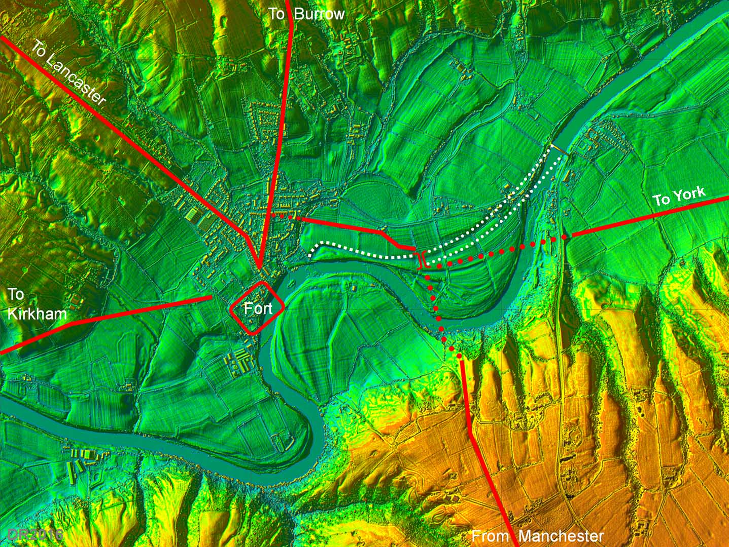
Possible River Ribble Bridge - Ribchester The site of the Roman bridge at Ribchester over the River Ribble has been the subject of much speculation. With the advent of Lidar we can now make an informed guess at to where it could well have been located. The route of the road down to the Ribble valley from Manchester and that of the road to York are visible in the Lidar data giving strong clues as to the bridge's possible location. Also visible is the probable linking road from Ribchester near Beech House. Note there is no evidence for the road from Manchester bypassing Ribchester and continuing on towards Jeffrey Hill. To get to Jeffrey Hill and the north then a diversion into Ribchester was evidently necessary. Despite these clear indication of the roads approaching the bridge site, the big unknown remained - where precisely was the river? Clearly is has moved over the centuries - witness the destruction of around 1/3rd of the fort itself. However, also visible in Lidar are earlier courses of the river, perhaps those dating from Roman times. Given that the roads would have been aligned on the bridge then its position can be surmised and a probable location for the Roman Bridge (see right). Given the southwards movement of the river, then the northern abutment would represent the best chance for survival. But would there be any supporting evidence on the ground?
|
Click for larger view |
 |
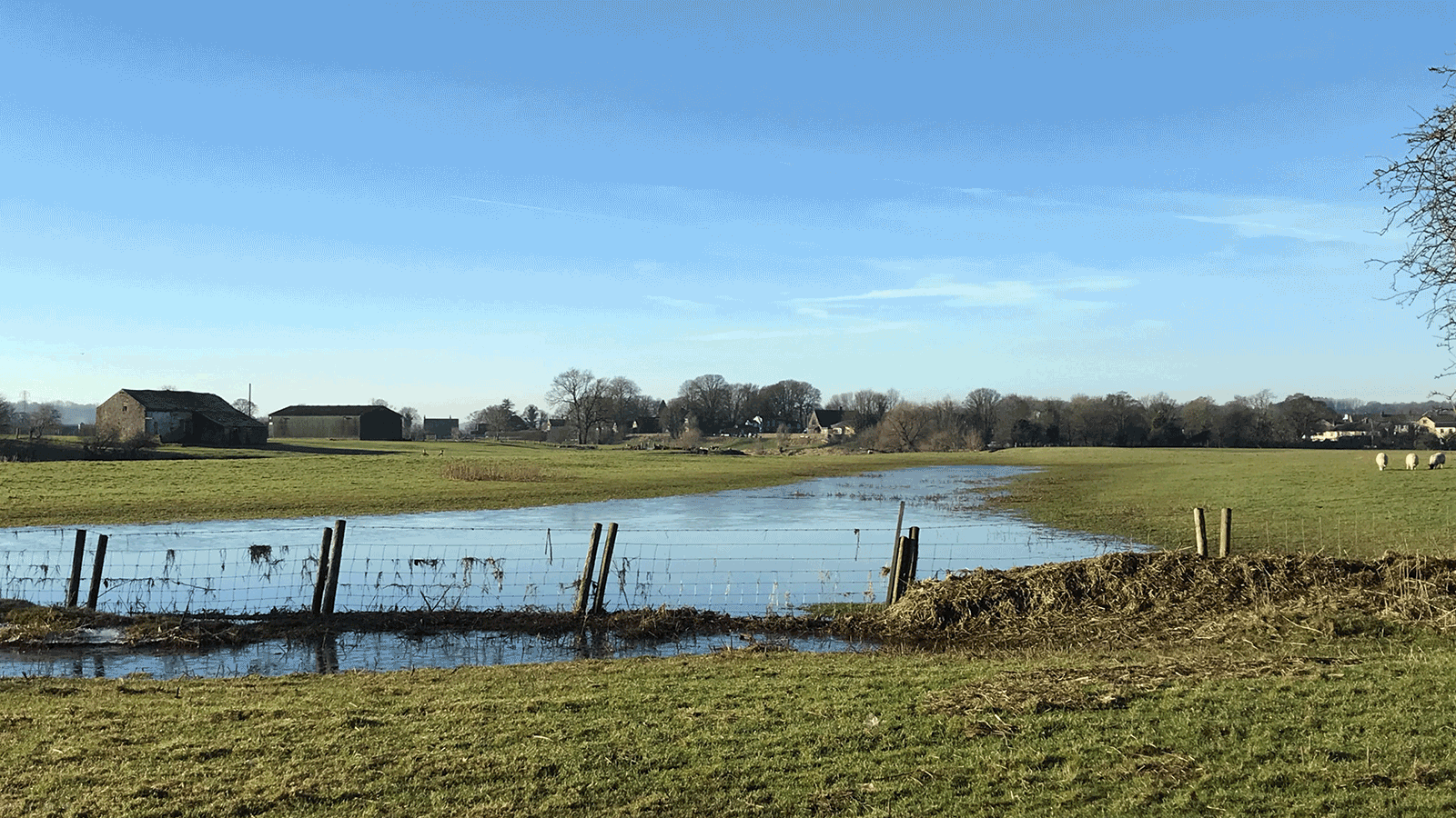
Roman Bridge Site We are looking down the old Roman river channel towards Ribchester. In the winter floods of 2024/5 water returned to this channel. The modern river is out of sight towards the barns to the left. The road crossed left to right here. In this animation a replica of what the Roman bridge could have looked like should appear. Background image - Andy Jackson, bridge - DR |
Click for larger view |
 |
Lidar Image - link road to Ribchester at Beech House Fortunately, in December 2016, the opportunity arose during a watching brief at Beech House to explore the possible bridge locations. Thanks are due to Nigel Neil and the landowner Mr Paul for their help and assistance. There were traces of an agger at two spots and where the bridge approach would have been there was a large assemblage of stones including one dressed sandstone block. There were none elsewhere. Does one dressed stone make a bridge? Probably not but it is a logical position for a bridge bearing in mind the alignment of the roads and the old river course there. The coordinates of the possible bridge's north abutment would be SD6566 3522. |
Click for larger view |
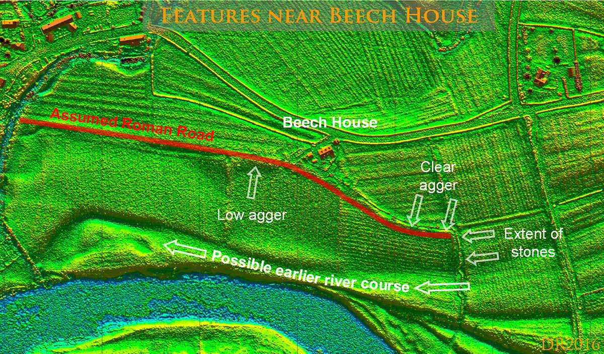 |
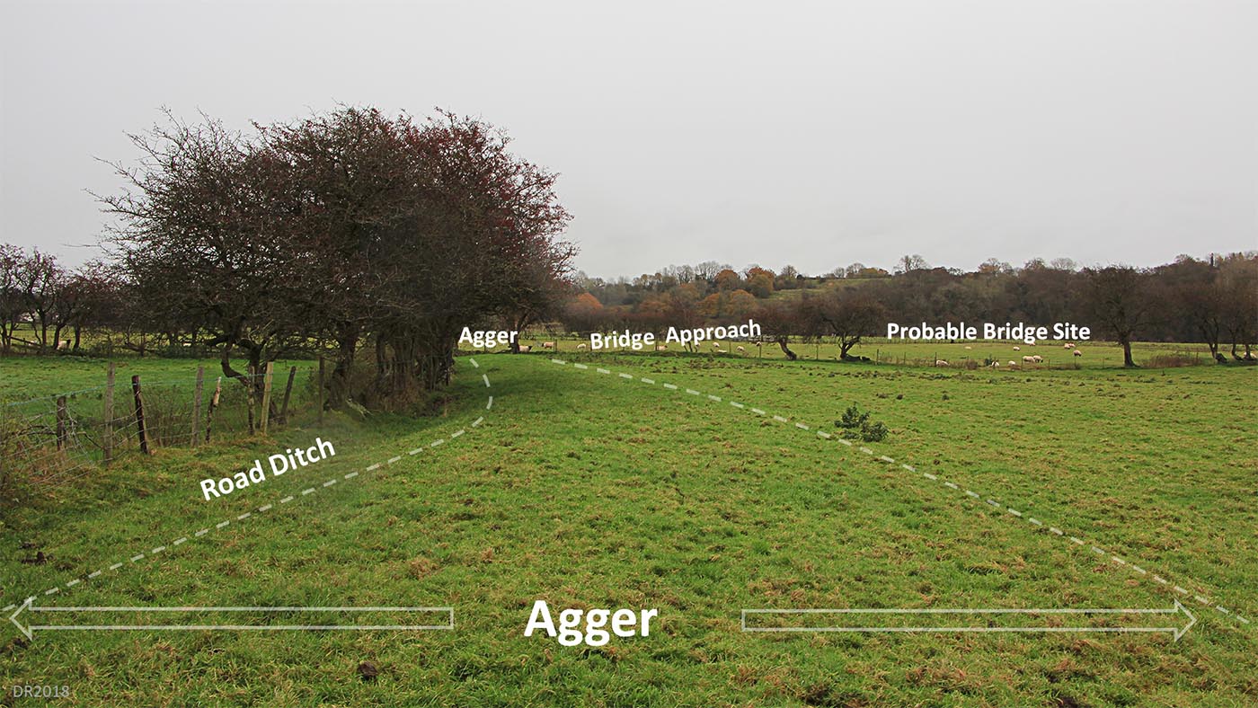
Looking East towards the possible bridge location, East of Beech House The agger is very obvious and definite here but it doesn't aim for the bridge abutment. This at first may seem strange but for there would have to have been an approach ramp to get up to bridge deck level. So the stone area would not represent the actual bridge just its approach. The bridge abutment would by alongside the river channel. Note in the winter floods of 2024/5 the water reached, but did not cover, the link road to Ribchester. How did they know where to put their road? |
Click for larger view |
 |
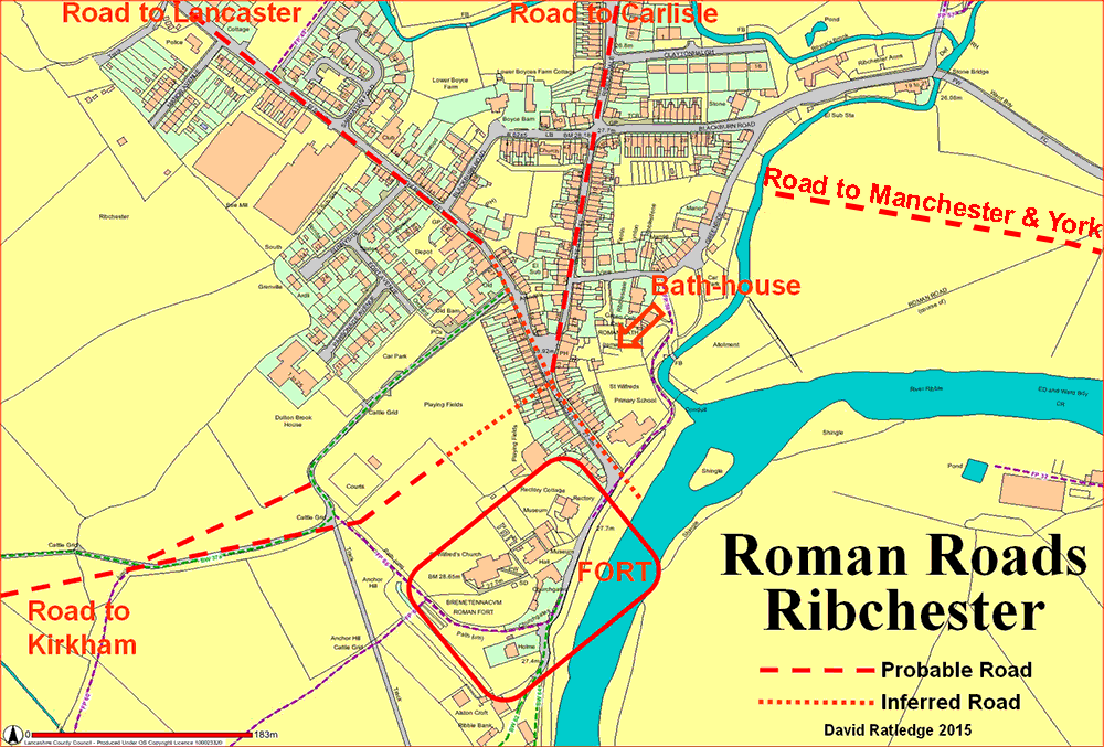
Ribchester Roman Road Map We can now complete a Roman road map of Ribchester with reasonable confidence. The original fort was further north than the later stone fort and the road layout was clearly designed/set out for the first fort. Disregard the Ordnance Survey line shown on the map for the road to the east. |
Click for larger view |
 |
|
|
|
Last update: January 2025 |
© David Ratledge |