Roman Roads in Lancashire - Historical Background |
|
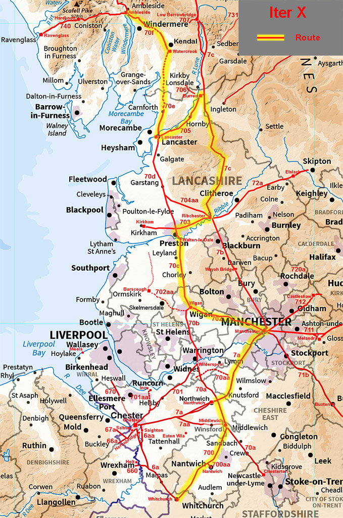
Antonine Itinerary XMedieval copies survive of a List of Roman Routes known as the Antonine Itineraries, which is believed to date from the early 3rd Century. It consists of a series of place names and the distance between them. The route of interest for Lancashire is the so called Xth Iter which follows a contentious route, North to South, through Ribchester and Manchester. A Roman mile (approximately 1500 metres) is coincidentally close to the British statute mile and it is, therefore, possible to make a direct comparison between the distances given in the Iter and the mileage by known routes between Roman sites. With Ribchester only known for certain it is difficult to interpret and therefore prove routes or names. The itineraries are notorious for copying errors only adding to the difficulty. However, we now know the road network much more securely. This rules out several previous suggestions where there are simply no road connections. Yes the solution I put forward has some distance anomolies - those copying errors? - but it uses real roads.
* D. Shotter, Romans and Britons in North West England, 1997 ** I.G. Smith, Britannia 1997 *** based on known roads Ravenglass is no longer believed to be Glanoventa and the OS Roman Britain Map 5th Edition places Glanibanta (=Glanoventa) at Ambleside. My suggestion is based on known secure roads and is similar to Smith's. As far as I can see it is the only viable solution based on the road network. Yes some mileages are in error but every solution has mileage errors too. Most have more errors. It places Alone at Lancaster. We know the Roman name began with L and the valley is called Lonsdale (River Lune). The route bypasses Watercrook – a surprise but not unique to the itineraries. Hincaster – the earthworks for the A590 blasted through Roman remains (pottery including Samian) but the exact location is not known but must be close to Margary 70e ie within 1 mile. Ribchester to Over Burrow is 29 miles and is a reasonable match to the 27 miles to Galacum, Ribchester to Lancaster being only 20.5 miles. Coccio/Coccium is now almost certainly confirmed as Wigan and its distance from Ribchester is given as 20 miles. The only known route between them is west to Fulwood and then south via Walton-le-Dale. This totals 24 miles. A direct route however would be a better match at 20.5 miles but evidence is so far not forthcoming. Wigan to Manchester is 17 miles, a good agreement. |
 |
|
|
|
Last update: 2022 |
© David Ratledge |