 |
Derbyshire's Roman RoadsA Lidar Re-appraisalSeveral years in the making - well at least 7. Other projects unfortunately restricted progress. Manchester to Melandra and Manchester to Buxton were the first followed by the Street, Buxton to Little Chester. The latter proving somewhat controversial as Lidar clearly revealed it took a direct course and did not go via Wirksworth. There is a big gap west of Buxton and surely there would have been a connection to Chester? The work is ongoing. Lidar, both 2D and 3D virtual reality models have been used extensively in appraising the course of the roads. This technique has proved an extremely efficient way of detecting linear feature such as Roman roads. Imagery derived from this data is often able to show clearly the surviving remains of the road agger, terraces, side ditches and cuttings, often where they cannot be identified easily on the ground through traditional fieldwork. Several of these roads were researched in conjunction with Neil Buckley, whose help was much appreciated. Some of these roads have been written up by Neil and references are given where appropriate.
|
 |
|
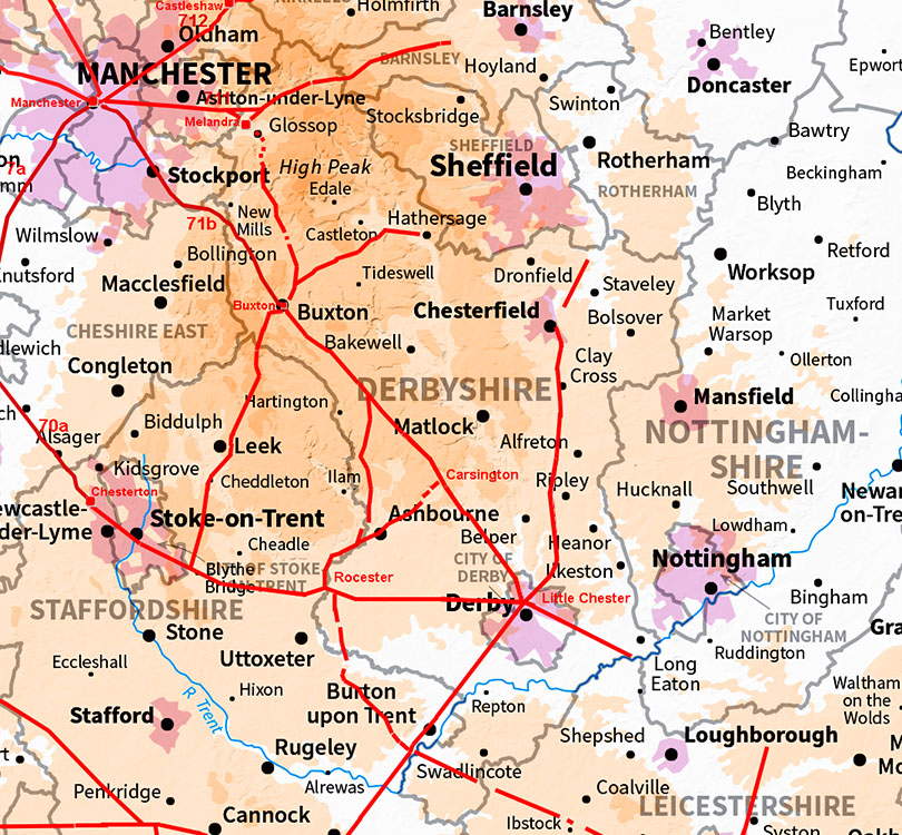
IntroductionA challenging county to build roads through! It is not called the Peak District for nothing. Yet the Roman highway surveyors were up to the task finding fairly direct routes through valleys and over high ground. As a result Derbyshire had a comprehensive road network with all sites interconnected. Both Little Chester and Buxton were important road hubs, each with 5 roads. Mention must be made of Lutudarum, almost certainly Carsington, which was the centre of lead processing. Lead pigs from Lutudarum have been found all around the country. Derbyshire's Roman RoadsFor all the known routes in detail choose the appropriate page:-The Roman Roads around Little Chester (Derby) Little Chester to Buxton, RR71a For a long time a puzzle as to the route the Romans took. At last we have the answer. Little Chester to Rocester, RR181, Well recorded road but with a discovery of a possible roadside fort. Ryknield Street (North), RR18d, Little Chester to Chesterfield and on to the county boundary. Ryknield Street (South), RR 18c, Derbyshire's straightest road? Little Chester to Long Eaton, RR182, Almost certainly connecting Little Chester to a port on the River Trent. The Roman Roads around Buxton Manchester to Buxton, RR71b Starts in Greater Manchester and crosses in Derbyshire at Disley. Buxton to Melandra, RR714 Just the northern section that is not fixed. We show a new option.. Batham Gate 1: Buxton to Brough, RR710a Well recorded road despite all the quarrying that has taken place. Batham Gate 2: Brough to Burbage Moor RR710b The continuation is clear to Hathersage where the problems begin. A suggestion is offered. Buxton to Leek & Blythe Bridge, RR713 Long suspected Roman road towards Leek and we extend it to Blythe Bridge. Other Roman Roads Melandra to Doncaster(?), RR715 A recently discovered road along the Longdendale Valley into Yorkshire almost certainly to Doncaster.. Melandra to Brough, RR711 Huge complications over this road with the Doctor's Gate route falling out of favour. Arbor Low to Rocester, RR716x Recently discovered road branching off the Street and heading to Rocester. Rocester to Carsington Route of RR716x suggests there was probably a Roman road to Carsington. Leicester to Rocester, RR573 Starts in Leicestershire passes into, then out of and back into Derbyshire and ends up in Staffordshire! Possible Roman Roads Longcliffe to Brough (Portway) An old route but with very little positive evidence that it could be Roman.. Buxton to the West Surely there was a road west from Buxton connecting to the Cheshire Roman sites. Evidence is weak though.
AcknowledgementsMy thanks ar due to Neil Buckley for his help with several of these roads. Thanks are also due to Mike Aerts for developing his bespoke "MAGIC" Lidar software that turns numbers into 3D virtual reality models Raw (ascii) Lidar is copyright DEFRA/The Environment Agency. The processed Lidar data shown here is copyright David Ratledge. Having said that, you are welcome to use any of the Lidar images providing a source reference is given. Mapping used is generally Ordnance Survey Opendata.
References:Below are general references. Specific ones pertaining to a particular road are included on the appropriate web page.
Codrignton, Roman Roads in Britain, 1903/1918. (Bill Thayer's online version). I.D. Margary, Roman Roads in Britain, 1957. Way out of date but still the first "go to" source book. The Margary road numbers used here are from this book. Peter Wroe, ROMAN ROADS IN THE PEAK DISTRICT, 1984. Quite out of date now but Peter did get a lot right. Derbyshire County Council HER Excellent online mapping for the County.
Contact:To contact David Ratledge regarding the Derbyshire web pages, please email me.
|
|

|
|
|
Last update: April 2026 |
© David Ratledge |