 |
Suffolk's Roman RoadsA Lidar Re-appraisalThis is the first version of Suffolk's Roman Roads web pages and has been compiled by David Ratledge. As such I will probably have made several errors and missed some important information - please let me know. I will not be offended! With your help we can make this the best available resource for Suffolk. The road numbering system is based on that devised by Ivan Margary over 60 years ago. Although long out of date it is still the best we have. However, several roads in Suffolk were unknown to Margary and therefore have no numbers. Lidar, both 2D and 3D virtual reality models have been used extensively in appraising the alignment of the roads. This technique has proved an extremely efficient way of detecting linear feature such as Roman roads. Imagery derived from this data is often able to show clearly the surviving remains of the road agger, terraces, side ditches and cuttings, often where they cannot be identified easily on the ground through traditional fieldwork. In addition, the Suffolk HER records and other written sources have been consulted.
|
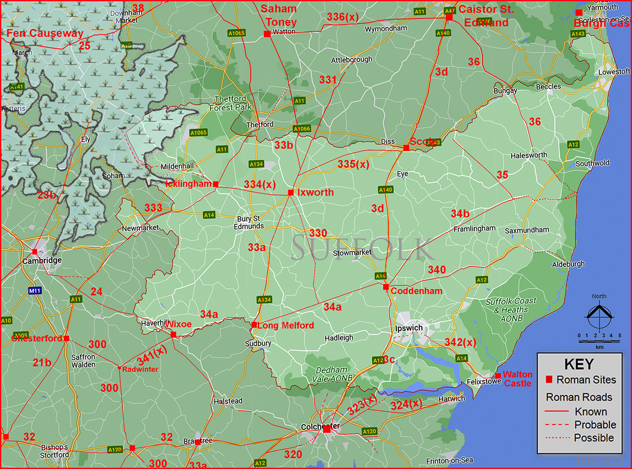 |
Road numbers are those allocated by Ivan Margary and the Fens are from Pryor |
IntroductionAlthough our route map, on the face of it, looks very familiar some "new" roads have been added plus several gaps have been filled in together with refinements here and there. Ixworth (Sitomagus) and Coddenham (Combretovium) were the two main road hubs for Suffolk. Two Antonine Itineraries pass through Suffolk, Iters V and IX. These have given us the Roman names of Sitomagus, Combretovium, Camborico and Villa Faustini. Thanks to the discovery that "new" road we can finally be confident in the location of Sitomagus which was previously the subject of much speculation. Ixworth was Sitomagus and Camborico was probably Icklingham. The east of the County is still a puzzle - perhaps more work is required here. It should also be pointed out the Romans would have exploited river and sea transport so the coastal area of the county would have also been served by boat. Suffolk's Roman RoadsFor all the known routes in detail choose the appropriate page:-Scole to Colchester Scole to Coddenham, Margary 3d Now the racetrack of the Norwich to Ipswich main road (A140). Commonly known as the Pye Road. Coddenham to Colchester,Margary 3c Just a few corrections to this largely known route to the important city of Camulodunum, Colchester. A possible second route into Colchester too. Other Roman Roads around Coddenham Coddenham to Long Melford, Margary 34a Perhaps Suffolk's straightest Roman road? Coddenham to Peasenhall, Margary 34b Very secure road but what was its real destination? Coddenham to Aldeburgh(?) via Stratford St Andrew, Margary 340 Another road heading east with the destination now pointing strongly to Aldeburgh The Roman Roads around Ixworth (Pakenham) Peddar's Way - Rushford Heath to Ixworth, Margary 33b Quite where Peddars Way ends in Suffolk is a bit debatable - we follow it north to south. Ixworth to Knettishall, Margary 331 Route is obvious in Suffolk - all the problems occur in Norfolk. Ixworth to Scole Route Discovered. The missing link that solved the Sitomagus location problem. Ixworth to Bildeston, Margary 330 All the gaps filled in but why did it go to Bildeston and not Coddenham direct? Ixworth to Long Melford, Margary 33a Very direct road that is easy to follow to Long Melford. Ixworth to Icklingham A road of two halves - the first section is straight forward but the second appears to comprise twin parallel routes. Roman Roads around Wixoe Wixoe to Long Melford, Margary 34a A little more of this elusive route has hopefully been located. Wixoe to Cambridge, Margary 24 The route around Haverhill was a little uncertain which I think has been resolved now. Wixoe to Braintree, Route Discovered. Yes the route is mostly in Essex but it completes the story of Wixoe as a road hub. Wixoe to Radwinter Route Determined. Another road almost entirely in Essex. Some parts had previously been spotted on aerial photos but Lidar has confirmed the whole route. Other East Suffolk Roads Stone Street, Margary 36 An important route from Caistor St Edmund to .....? We cover Wainford to Halesworth and then speculate! Peasenhall to Harleston, Margary 35 I have quoted Harleston as the destination this was almost certainly not the case. Some suggestions given. Ipswich to Walton Castle Probably originally a road to a Roman port at Felixstowe then extended to the later (lost) Saxon Shore fort of Walton Castle. Other Roman Roads The Icknield Way, Margary 333 Most likely a pre-historic trackway that was adopted and improved by the Romans where they deemed necessary. Icklingham to Prickwillow There is good evidence for a road west from Icklingham to the famous Roman Canal west of Mildenhall. Miscellany East Suffolk Puzzle Where do all those roads heading towards East Suffolk have as their destination? Some suggestions. Sitomagus & Itinerary IX At last the mystery of Suffolk's lost Roman town has been resolved. Ixworth/Pakenham Roman Site Details of probably Suffolk's most important Roman road hub where 6 roads met.
AcknowledgementsTop of the list for thanks must be to Suffolk Historic Environment Record (HER) and their online database and mapping. Local books I found particularly useful were Boudica to Raedwald by John Fairclough and Prehistoric & Roman Essex by James Kemble - see references below. Thanks are also due to Mike Aerts for developing his bespoke "MAGIC" Lidar software that turns numbers into 3D virtual reality models. Raw (ascii) Lidar is copyright The Environment Agency. The processed Lidar data shown here is copyright David Ratledge. Having said that, you are welcome to use any of the Lidar images providing a source reference is given. Mapping used is generally Ordnance Survey Opendata supplemented by Bing Mapping and Aerial Photography for selected areas. Google imagery has also been utilised.
References:Below are general references. Specific ones pertaining to a particular road are included on the appropriate web page.
Roman Roads in Britain, Codrington, 1903/1918. (Bill Thayer's online version). Roman Suffolk, I.E. Moore, Suffolk Institute of A & H, Vol XXIV, 1948. Some information on roads but no map. Roman Roads in Britain, I.D. Margary, 1957. Way out of date but still the first "go to" source book. The Margary road numbers used here are from this book. A Context for Sitomagus Romano-British settlement in the Suffolk mid-coastal area, Robert Steerwood, Suffolk Institute of A & H, Vol XL, 2003. It wasn't on the coast after all. Prehistoric & Roman Essex, James Kemble, 2009. Despite the title it includes south Suffolk as well. Boudica to Raedwald, East Anglia's Relations with Rome, John Fairclough, 2010. Includes a chapter and appendix on Suffolk's Roman roads.. Felixstowe Roman Fort,, John Fairclough, Suffolk Institute of A & H, Vol XLII, 2011. Includes the suggested route of a connecting road. The Roman Roads of Suffolk, A Lidar Reappraisal, David Ratledge, Itinera - Journal of the Roman Roads Research Association, Volume III, 2023 Suffolk Heritage Explorer The primary site for all Suffolk's Historic Environment Records (HER). Suffolk History Hub New site for 2022 "for anyone with an interest in Suffolk’s history." Keith Briggs Web Site Digitised Margary RR maps plus author of ."A dictionary of Suffolk place-names" St Edmundsbury David Addy's excellent site on local history in West Suffolk.
Note: Suffolk Institute of A & H = Suffolk Institute of Archaeology and History Contacts:To contact David Ratledge regarding the Suffolk web pages, please email me.
|
|

|
|
|
Last update: August 2023 |
© David Ratledge |