
|
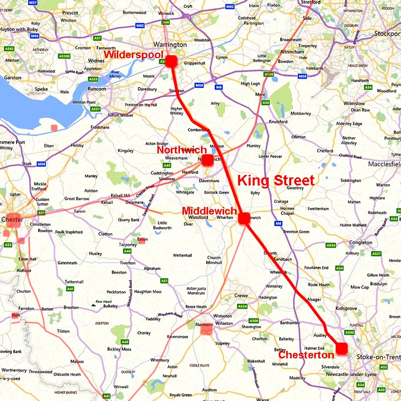
King Street, the Roman Road from Wilderspool to ChestertonMargary Number: 70aDistance: 30 milesKing Street is the major Roman north-south route through the county. As such it has been suggested (ref: Professor David Shotter) that it is based on the original invasion route for North-West England. This theory has perhaps fallen out of favour in recent years with a route via Manchester and Ribchester thought to be probably the earlier. A puzzling feature of the road is how it bypasses Northwich 1.5 miles to its east. The route of the road is well documented in the north of the county but the nearer it got to Chesterton then its course was lost with several alternative suggestions. The biggest clue to tracing it south is that the road direction just south of Sandbach appears to be aligned on the high ground near Bignall Hill/Wedgwood's Monument. This represents a logical direct alignment but until lidar then evidence was not forthcoming. An alternative route via Lawton Heath was suggested over 100 years ago by Watkin (Roman Chester, P73). He did caution this and thought a direct route more likely. However, we can now be confident that the route took a very direct course and went over Bignall Hill/Wedgwood's Monument as the Lidar evidence is convincing there. Watkin's thoughts were correct! Note this road is sometimes referred by its alternative name of Kind Street. |
Historic Counties: Cheshire & Staffordshire Current Counties: Cheshire & Staffordshire HER: Cheshire & Staffordshire
|
|
|
|
|
|
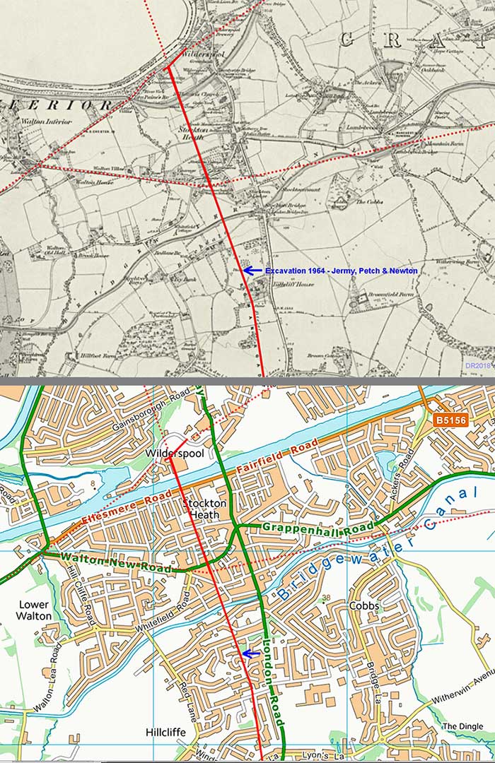
Wilderspool - Roman Sites & Roads The Roman settlement at Warrington/Wilderspool seem to have been quite extensive from Stockton Heath in the south to under Warrington town centre itself. It appears to have been an important road junction with not just King Street but a probable road to Chester and perhaps one to Manchester as well. There also appears to have been two river crossings. Presumably a bridge at Wilderspool on the direct road north to Wigan and a second, probably a ford, at Howley. No fort has been found (yet) so it is classed as an industrial site and port with a primary purpose of supplying the military in the north-west. Ref: Cheshire Historic Towns Survey, Warrington |
Click for larger view
|
 |
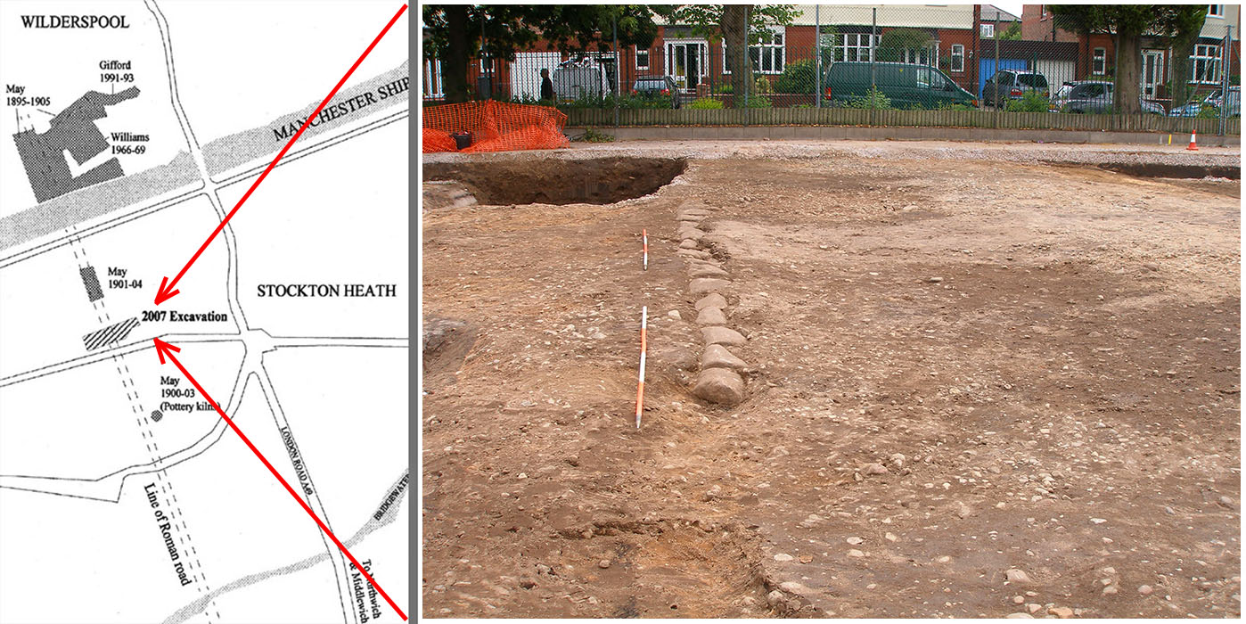
Stockton Heath - Excavation 2007 with King Street Roman Road (SJ 61208619) Excavations prior the building of a new school at Stockton Heath (Wilderspool) in 2007 by Earthworks Archaeology found King Street itself and various timber structures flanking the road. There was evidence for two overlying roads forming a cambered construction of 13 metres. The phase 2 later road on top had no ditches but did have kerbstones indicating a road width of 6 metres - visible in the picture right.. Ref: Excavation of a Roman roadside settlement at Stockton Heath, Warrington 2007 From : Journal of the Chester Archaeological Society 81 Publication Date: 2006 Author(s): Leigh Dodd, Fiona Grant, David Shotter, M Ward (Earthworks Archaeology). Image reproduced courtesy of Leigh Dodd of Earthworks Archaeology to whom our thanks are due. |
Click for larger view
|
 |
OS First Edition & Modern Map - Excavation at Appleton by Jermy et al. 1964 Ref: Petch, D. F., Newton, C. A. and Jermy, K. E., (1965). King Street - A Roman road in central Cheshire. Journal of the Chester Archaeological Society 52. Vol 52, pp. 23-25. The following is taken from the above paper:- In 1964, a new housing estate was built at Appleton, between Hillcliffe Hydro and Warren Drive, straddling the line of the Roman road. During a preliminary visit to the site, a road layer was discovered; this was 6in. thick, Min. below ground level, and resting on a layer of clean orange-coloured sand. The road layer was made of pebbles up to 5in. size, topped by gravel of average size fin., which is taken to be part of the road surface. Gravel and pebbles are quite foreign to this site; the natural layers are massive, slab or disintegrated red sandstone. On 18 February, 1964, the site agent kindly extended another section near here, already partly exposed, by mechanical excavation. This section was later measured, and is shown in Fig. 1 (below). The section was incomplete (as shown by dotted lines), but the western edge of the road structure was identified with certainty, and the indications were that the eastern end of the section was within a foot or two of the road edge. The measured section shows a road width of at least 34 feet at this point. The structure was 1 foot below ground surface, and was roughly 2ft. 6in. thick over most of its width. It was mainly composed of compacted sand and gravel, fairly well stratified at the western half of the section, with some distinct narrow layers of dark staining. The structure was placed directly on the dirty brown sand layer which overlies the natural soft red sandstone, except that at the eastern half a layer of clean sand was placed below the road structure. In both the western and eastern portions a layer of red clay, up to 6in. thick, was interspersed within the pebble layers, but these two clay layers were at different depths and did not join. |
Click for larger view |
 |
Appleton Excavation - Cross-section The section raises several problems of interpretation. .....The presence of clay layers in the actual road structure is very unusual, particularly in Cheshire. The clay layer towards the top of the western half of the section may represent a hurried repair in Roman or post-Roman times; this, however, does not tally with the low clay layer in the eastern half, unless this was part of a widening or rebuild of some kind, as suggested above. The fairly heavy layers showing dark stain are difficult to explain. These are unlikely to represent brushwood layers, as suggested by Thompson at Stretton, since the road at Appleton is descending a hill-slope on which there is no suggestion of marshy ground to negotiate. The fact that these layers occur under the clay layers may indicate decayed vegetation covered by repairing or new road construction. Another possibility is that they are equivalent to the “pan” which has been found underneath the turf rampart of the fortress at Chester. The eastern edge of the section described was at 61468547, a point roughly 80 yards NW of the NW corner of Hillcliffe Hydro building. The suggested course of the road in this area on the O.S. 6-in. sheet is thus some 20 yards too far to the west. |
Click for larger view
|
 |
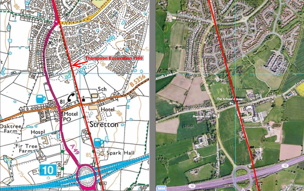
Excavation by F H Thompson 1969, north of Stretton Church Ref: Thompson, F. H., (1961). Notes on Roman roads in Cheshire. Journal of the Chester Archaeological Society 48. Vol 48, pp. 25-26. The following is taken from the above paper:- In March, 1960, the laying of a petrol pipe-line from the Stanlow refinery to Manchester afforded a fresh opportunity for an examination of the road structure. The pipe-trench was mechanically excavated and crossed the line of King Street, approximately at right-angles, at a point 300 yards north of Stretton Church (Nat. Grid Ref. 619831 on sheet 101). The road appeared clearly in section in the sides of the trench; it was 18 ft. wide and its western edge coincided with the hedge-line which here runs parallel with it. Beneath 9 in. of dark plough-soil a gently cambered surface of pebbles and sandstone chips rested on a layer of brown sand, 4 in. thick. This in turn rested, for rather more than half the width on the west side, on a thin black layer (? brushwood), beneath which appeared a thin layer of light grey clay, characteristic of an old ground surface on boulder clay. To the east, the under lying boulder-clay fell sharply away into a sand-filled ditch, presumably for drainage, though it was difficult to determine its precise dimensions in the section. On the west, there was a similar but shallower scoop; this however was filled with plough- soil and more probably represents the silted ditch associated with the hedge. The cutting of this ditch may have disturbed the west edge of the road, so that 18 ft. can only be the minimum width of the road, though it is unlikely to have been very much more. |
Click for larger view
|
 |
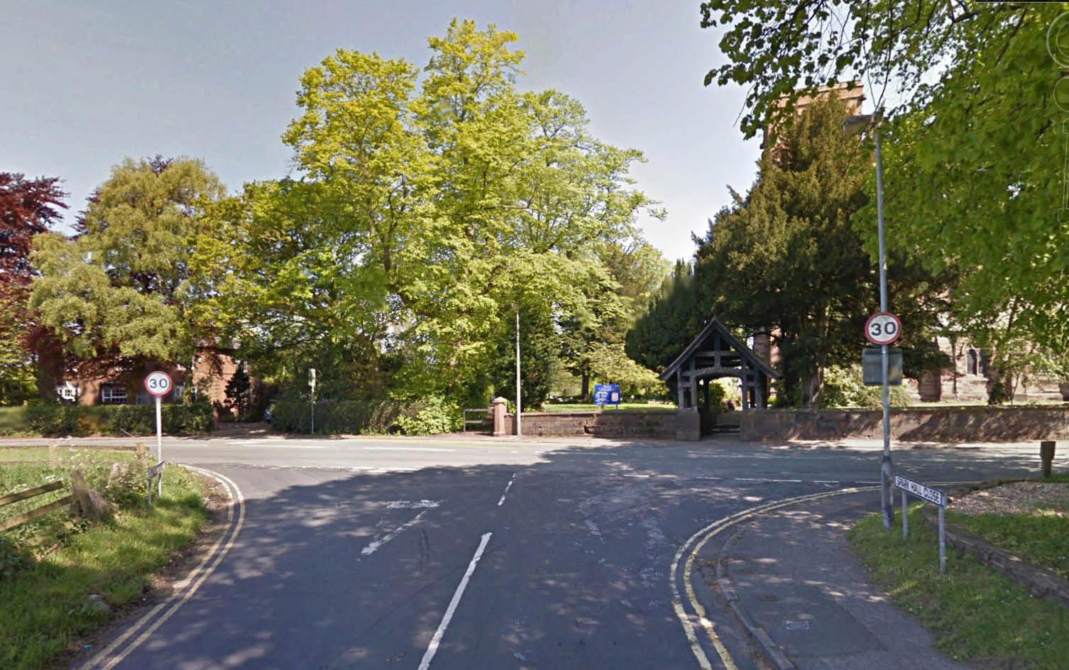
King Street - Stretton Church This is looking north to Wilderspool. The Roman line is left of the churchyard marked today by a footpath.
|
Click for larger view |
 |
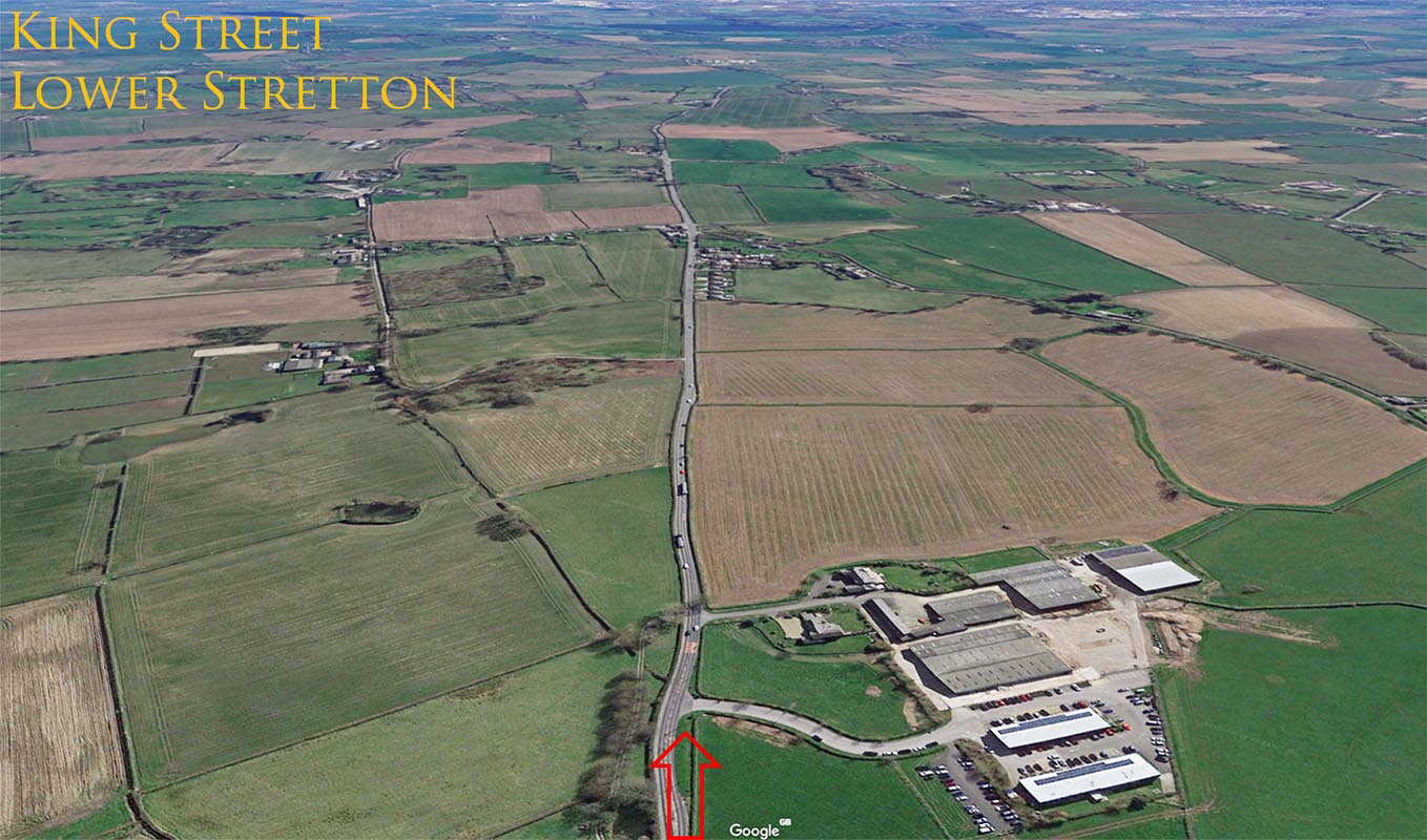
King Street (Northwich Road), Lower Stretton - looking South Beyond the M56 Motorway, King Street heads for open country. However, in the main it is overlaid by Northwich Road, A559. Image: Google Earth |
Click for larger view |
 |
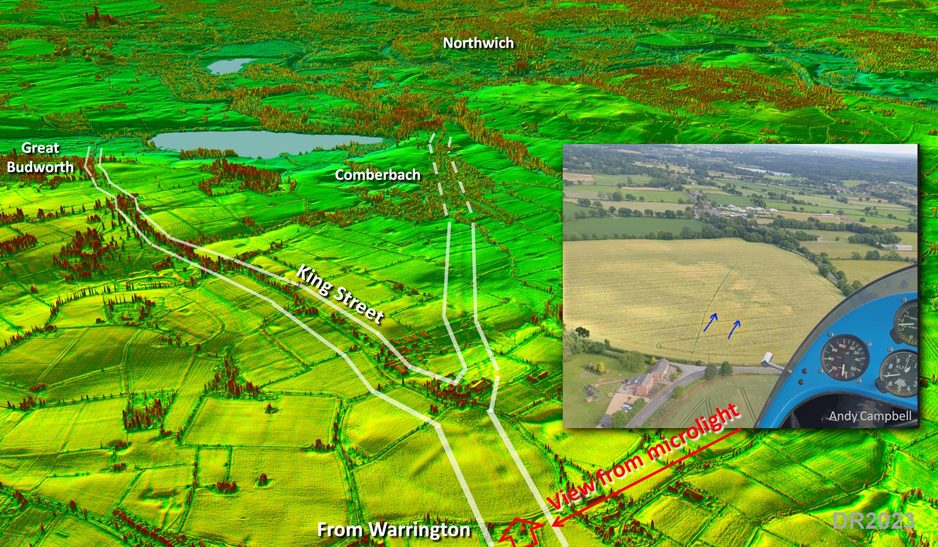
Oblique Lidar Image - King Street, Frandley & Northwich Link Road. Spotted in 2023 by Andy Campbell is a Roman road branching off King Street at Frandley. Clearly this was a direct link road to Northwich as King Street itself passes 1.5 mile to the east of Northwich so a short cut was always likely. The modern road through Comberbach probably marks its onward course to the fort in Northwich. Inset is a view by Andy taken from a microlight. This shows the twin road ditches of King Street just before the link road branches off. Note: in mine and Neil's defence for not spotting the link road as in 2018 there was a gap in the Lidar coverage just here. That's our excuse anyway! |
Click for larger view |
 |
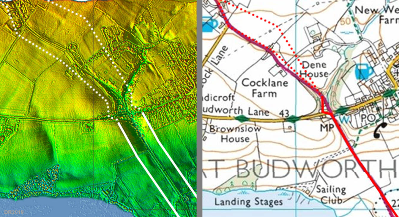
Lidar Image - King Street passing Great Budworth The route of King Street approaching Great Budworth is somewhat vague with two options - one through the fields, where there is some lidar evidence, and one more closely following the A559. Thanks to Alan Bailey of Budworth we have now included a zig-zag in the Roman road here. This is evident from old maps of the village but has now been bypassed by a straight modern road improvement. |
Click for larger view |
 |
Lidar Image and Route Map - King Street passing Northwich King Street rather puzzlingly passes over 1.5 miles to the east of Northwich Fort. The fort would have been accessed by the road in from Manchester but it is still an odd arrangement. The actual junction with the Manchester road can only be inferred by projecting from the known sections but this is probably pretty close to reality. |
Click for larger view |
 |
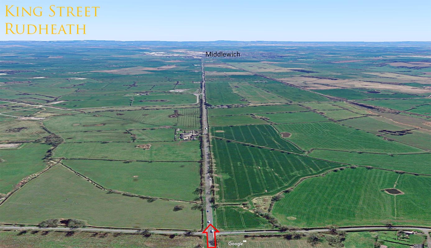
King Street, Rudheath - looking South Beyond Northwich, the A530 overlies the Roman Road. Here it is actually called King Street and is very straight all the way to Middlewich. |
Click for larger view |
 |
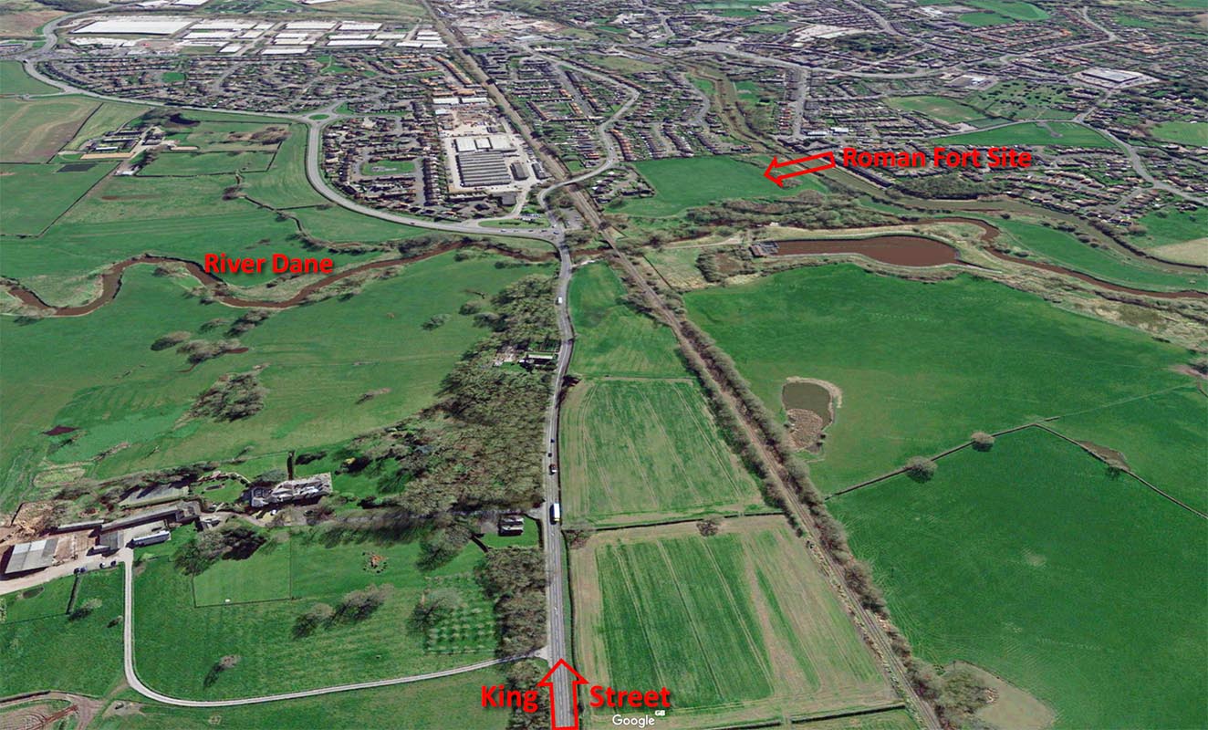
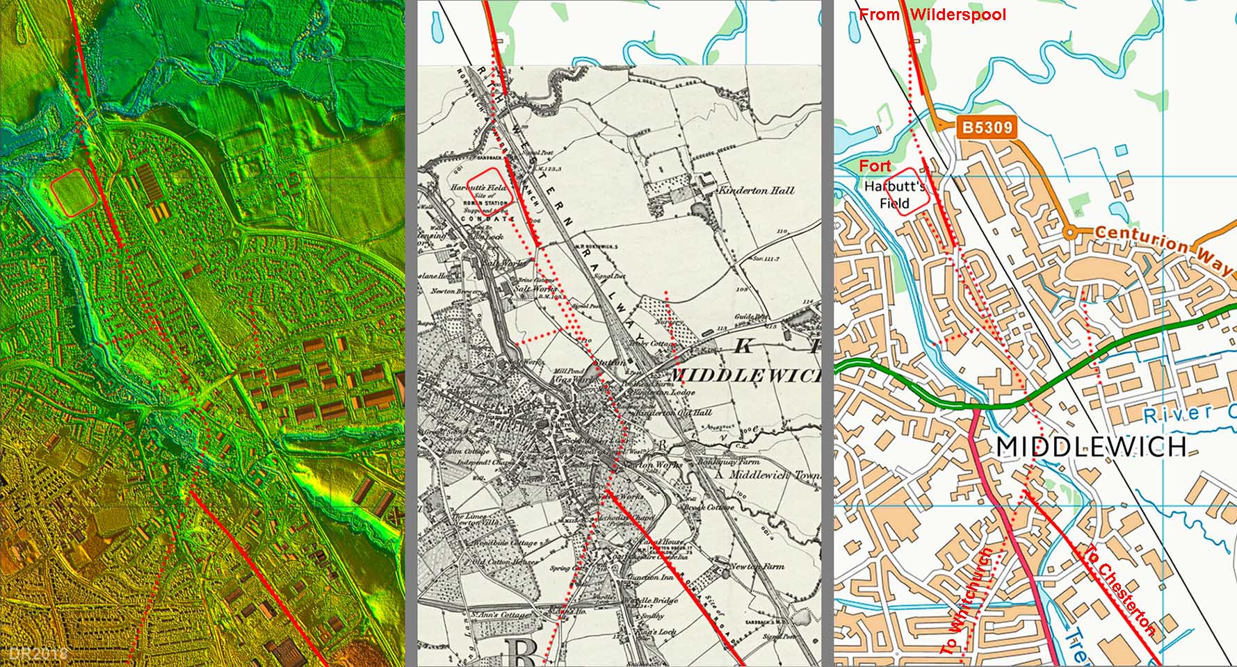
Middlewich - Google Earth 3D View The Roman fort in Middlewich was sited at Harbutts Field and King Street had to cross the River Dane for its approach. For details of the Harbutts Field fort - follow link
|
Click for larger view |
 |
Middlewich - Lidar Image, OS First Edition Map and Modern Map The dotted roads are those recorded in Cheshire County Council's Historic Town Survey for Middlewich. Not perhaps totally convincing for the site of the River Dane crossing as King Street would more likely have continued straight-on to the bridge site. The road arrangement south of the town may seem a little odd but there would have been the need for a dog-leg to cross the valley now occupied by the Trent & Mersey Canal. The Whitchurch road would have left hereabouts but its precise course is somewhat uncertain but what is shown is probably close to the truth. |
Click for larger view |
 |
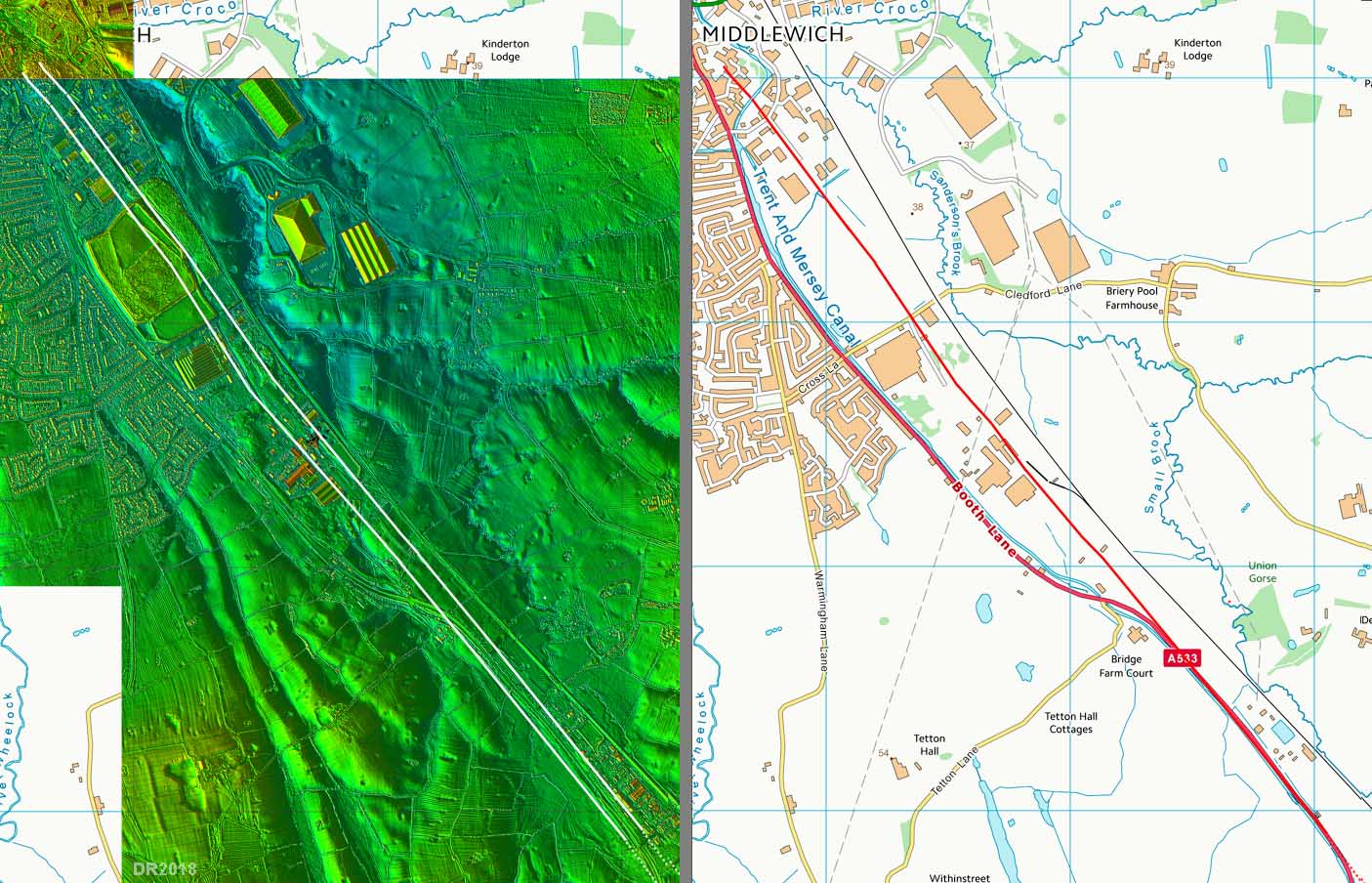
Middlewich South - Lidar Image and Route Map Not a lot of evidence visible in the Lidar data (thanks to industrial development) but there is no reason not to assume a straight course here and it eventually merges into the A533. |
Click for larger view |
 |
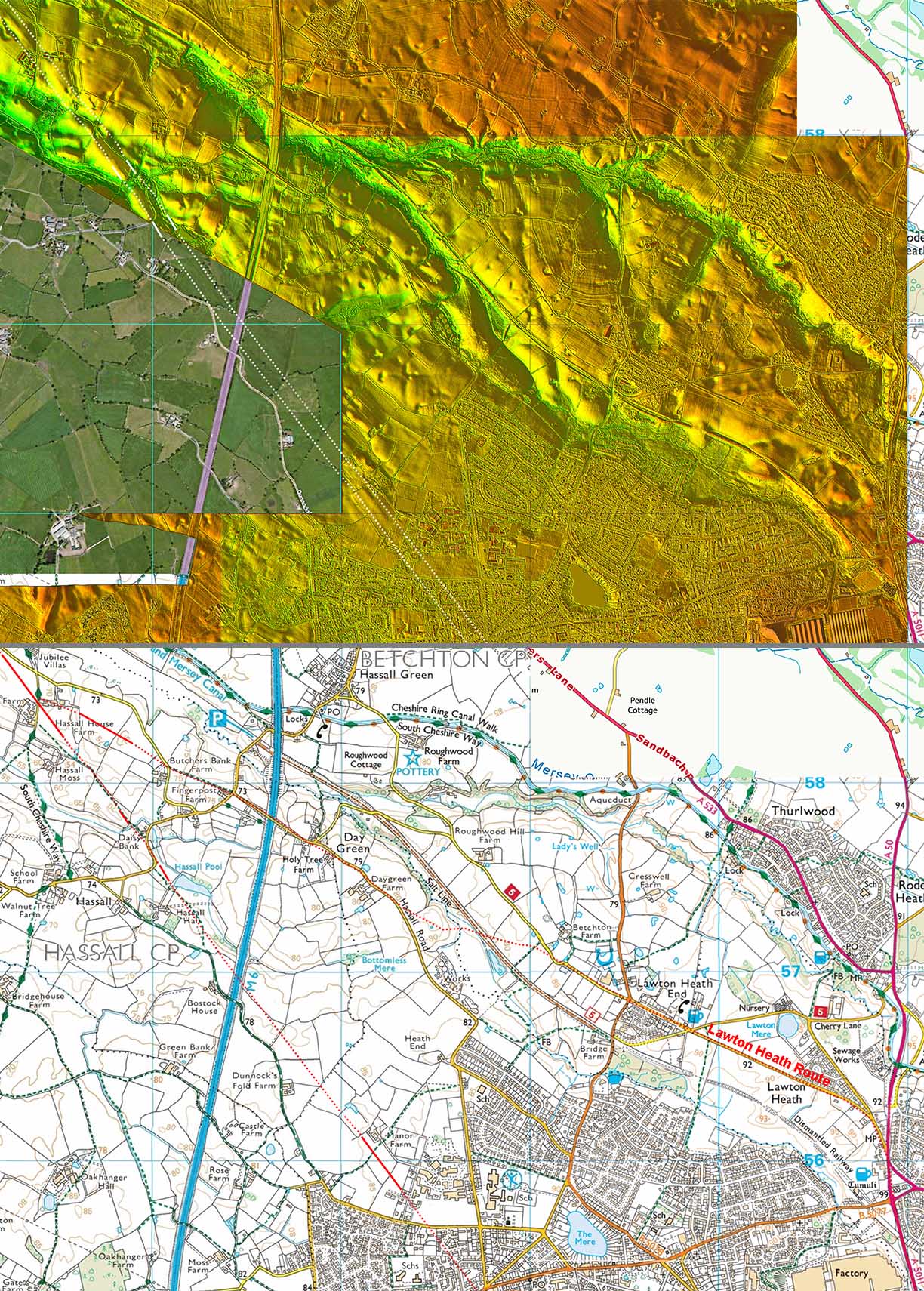
Elworth, Sandbach - Lidar Image and Route Map This is the critical alignment as it probably determines which course the road takes south of Sandbach. All the clues line up: the A553, a length of lidar agger, OS first edition map route, Abbeyfields excavation and finally another agger visible in the Lidar data. This rather confirms the direction of the road south of Sandbach will not be along the A533 as has been suggested in the past. The Roman road is taking a much more direct course to Chesterton and this straight alignment would appear to have been set-out from the vicinity of Bignall Hill/Wedgwood's Monument (see route map 2 below). |
Click for larger view |
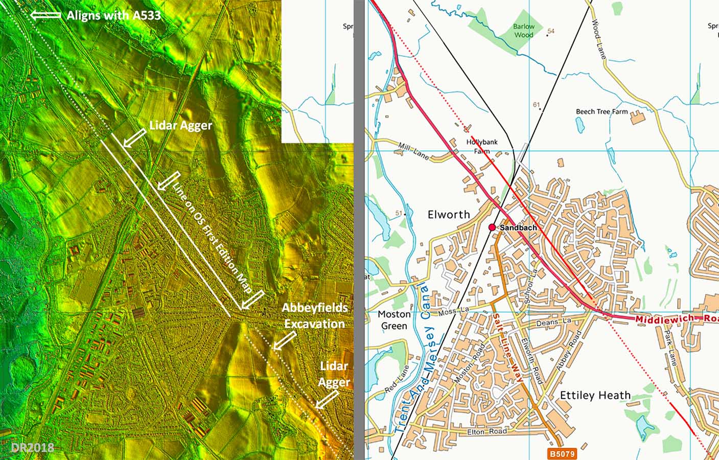 |
Abbeyfields Excavation (SJ 7465 6071) This is reproduced from Cheshire HER record 436/1/17 (copyright Cheshire CC) but the evidence derives from A York's book "I once was Lost but now I'm Found", 2010. The excavation recorded a road c. 8 metres wide with large camber. The location is marked on the map above and lines in perfectly with other evidence in the locality. |
Click for larger view |
 |
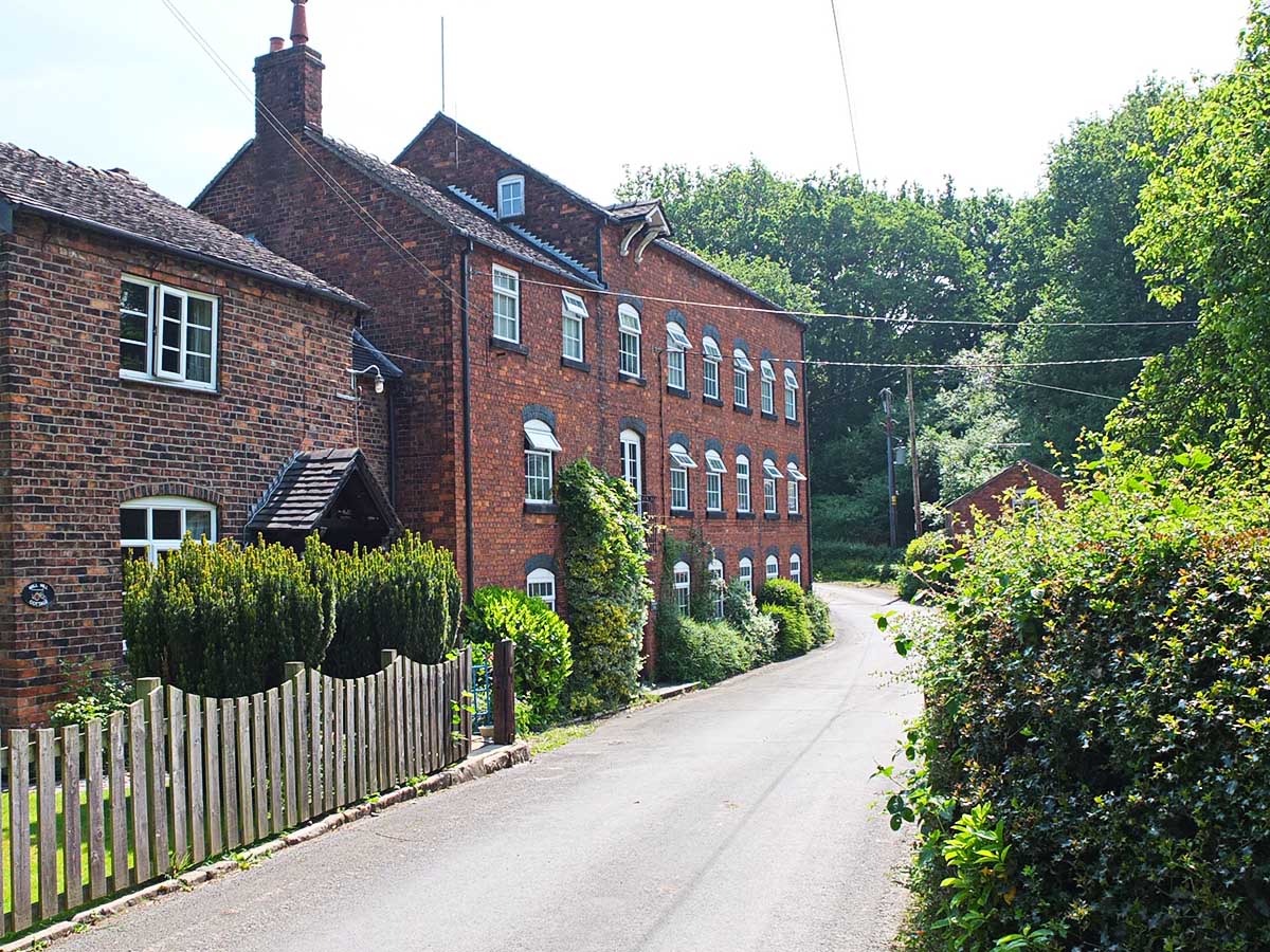
Mill Hill Lane, Sandbach The bridge and lane at Sandbach Mill preserve the Roman line so the river crossing point here is almost 2000 years old. The modern road turns to the left beyond the mill but the Roman line turned right - see below. Image; Neil Buckley |
Click for larger view |
 |
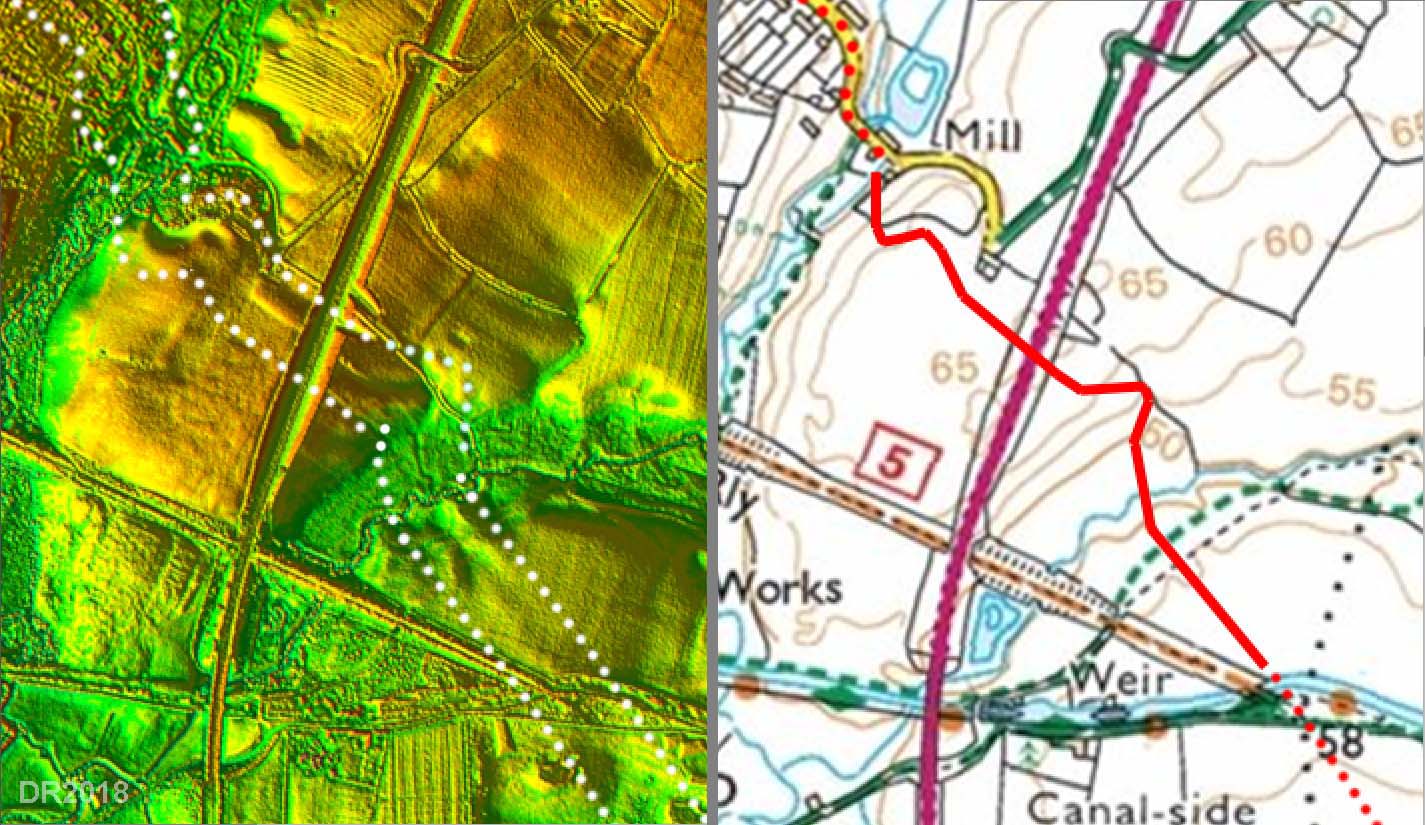
Lidar Image & Route Map - crossing the A534 The climb up to and down from the A534 crossing are very clear on the Lidar data. Again this is very typical Roman engineering to get up and down gradients.
|
Click for larger view |
 |
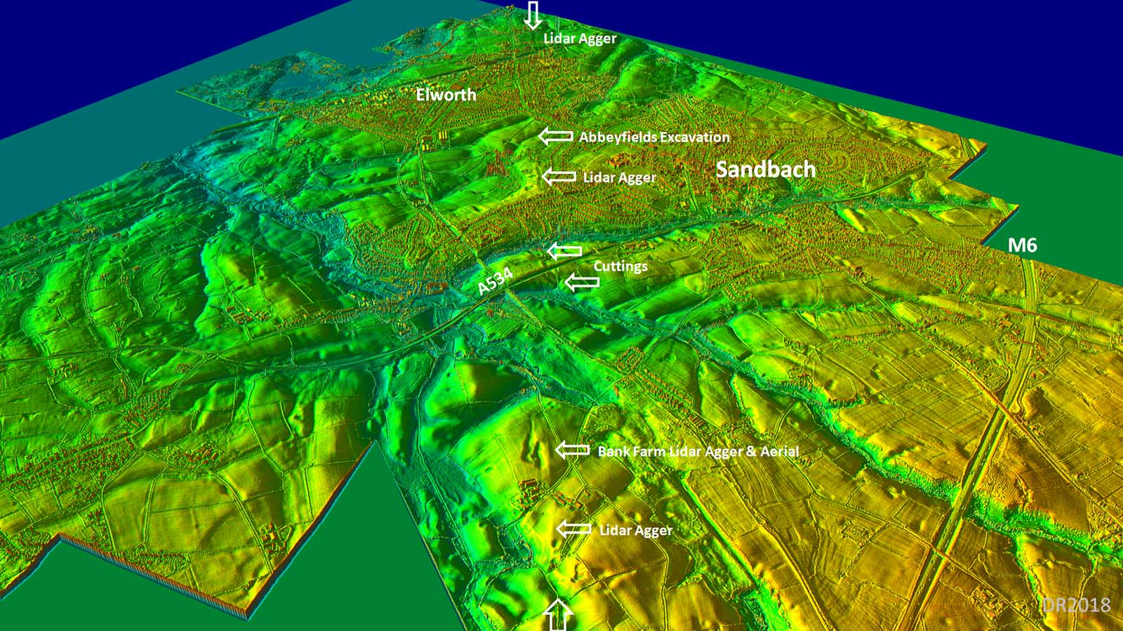
3D Oblique Lidar Image - looking north-west over Sandbach and Elworth The alignment through Elworth and Abbeyfields (see above appears to continue further south to Hassall House Farm. Unfortunately the lidar data currently (2018) runs out there so tracing it further required consulting aerial photographs. |
Click for larger view |
 |
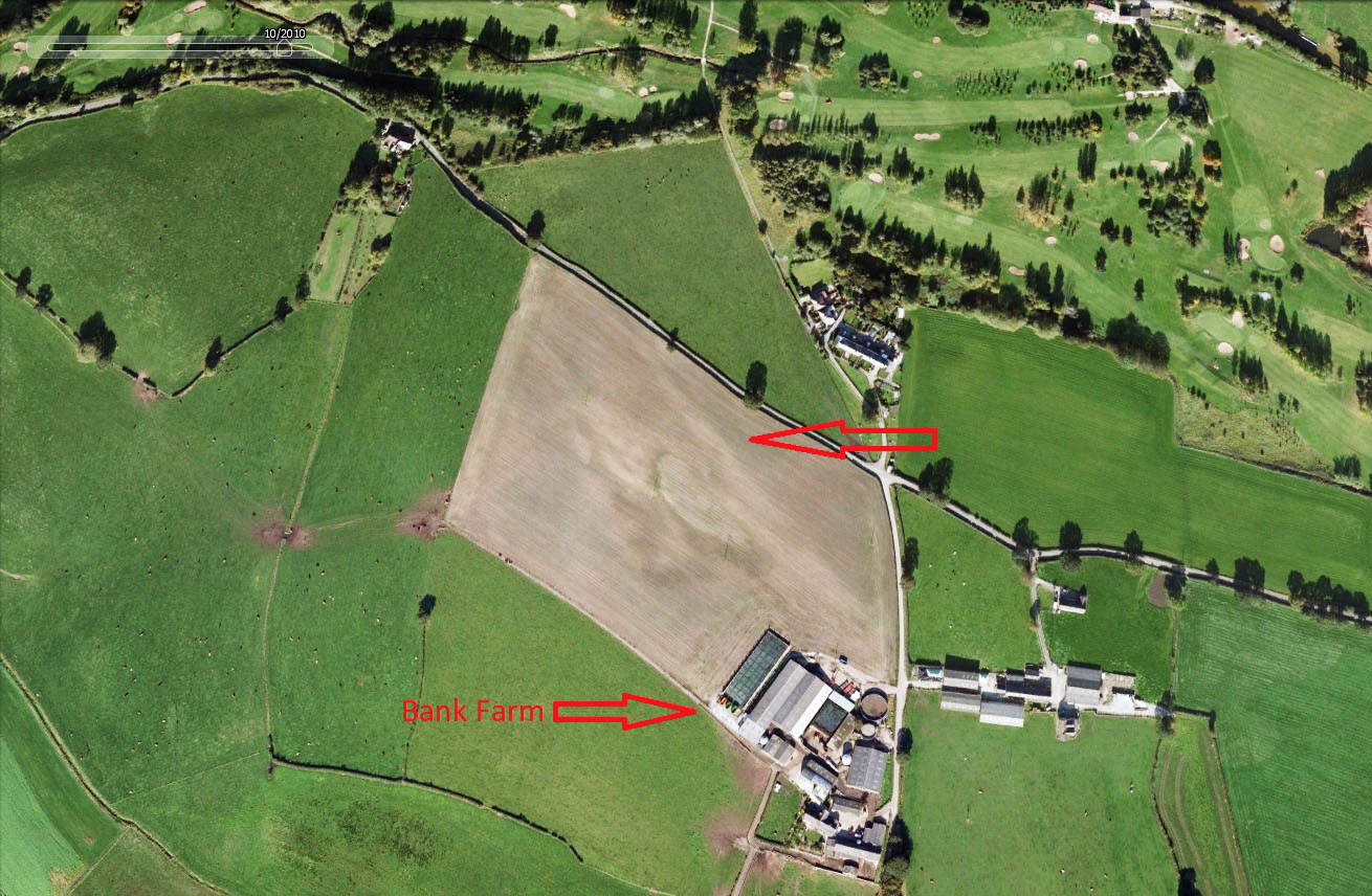
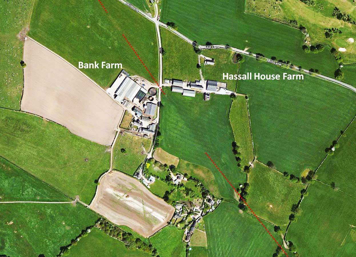
Aerial Photo - Bank Farm, Hassall (GoogleEarth) The agger approaching Bank Farm at Hassall not only is evident in the Lidar data but shows up well as a lighter strip. This section perhaps the last very definite course of the road - south of here then the clues start to dry up. |
Click for larger view |
 |
Aerial Photo - Bank Farm, Hassall (Bing) In this aerial the course of the road across the field south of Hassall House Farm is evident as a change in grass colour - presumably due to a change of slope at the agger. On the basis of the Lidar data and this image it would appear that the direct direction of the road is continuing. |
Click for larger view |
 |
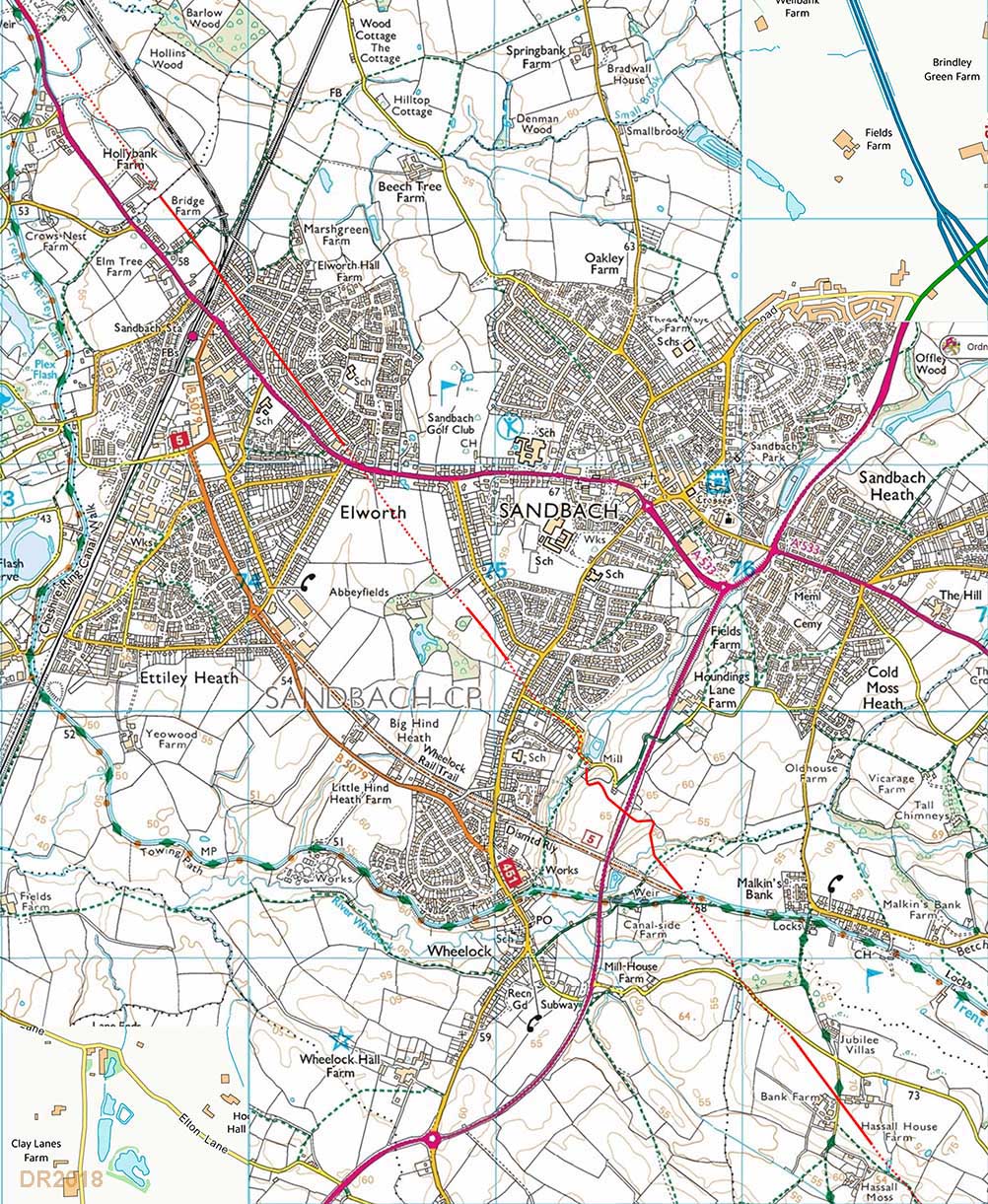
Sandbach Route Map The route across Sandach can now be plotted with reasonably high confidence. All the evidence points to a pretty direct alignment apart from the normal deviations to get up and down gradients. This alignment is pretty direct and expectations would be that it continues unchanged to Chesterton but proving this has proved difficult. 2020 Update We were contacted by Tony Kehoe who advised of his paper: "Extending the Known Route of the Middlewich to Chesterton Roman Road (2011-2012)" published in Cheshire History (Cheshire Local History Association Number 54 2014-2015). This paper independently came to the almost identical route for this road between Sandbach and Alsager to that we determined using Lidar and published here. |
Click for larger view |
 |
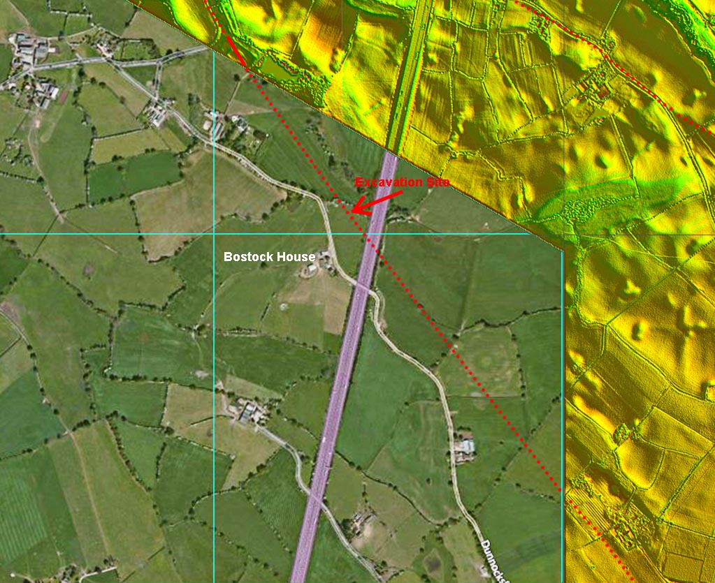
Excavation Site at Bostock House (SJ77381 57058) This is the site excavated by Tony Kehoe, Alex York, Sharrat & others in 2011/2012 . Although the full width of the road was not determined, the stratified remains of the road were revealed (see below). |
Click for larger view |
 |
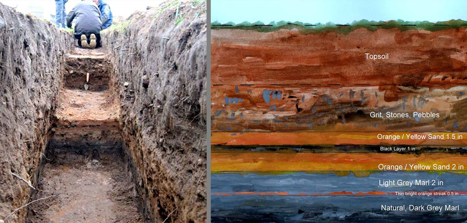
Excavation at Bostock House The contruction of the road would seem to have been typical of Roman roads in Cheshire i.e. use of sand and clay/marl for foundation layers. Images: Tony Kehoe |
Click for larger view |
 |
Hassall to Lawton Heath - Lidar & Route Map (Two Routes) An alternative route via Lawton Heath was considered an option. The latter does have a HER record (see below) flagging its possibility to be part of King Street. It is straight but is well off the direct line to Chesterton. The HER record for Lawton Heath is based on Watkin and his comments are probably still relevant today. "The road may still be traced as described by the Archdeacon, and is marked on the ordnance Survey Map; but its course beyond Sandbach is difficult to trace. Either it, or a branch from it, seems visible for about half a mile to the N.W. of Lawton Heath, which is used as a road still; and again at "Lawton Pavement" we have another trace of one of them, where here makes an angle to the south, and passing the county boundary proceeds towards Talk on the Hill, just beyond which there is a "Windy Harbour" on its route, keeps on through "Red Street" and about a mile further reaches Chesterton. It is probable, however, that the main line of the this road pursued a more direct track, though as yet it has not been detected, from the neighbourhood of Sandbach to Chesterton." So Watkin thought the Lawton Heath was probably not the route to Chesterton and believed a direct route more likely. The two roues are both shown on the map (but not on the Lidar). However, in view of Lidar revealing the obvious signs of the route ascending Wedgwood's Monument then the Lawton Heath road - if it is a road - must have been heading somewhere else than Chesterton. |
Click for larger view |
 |
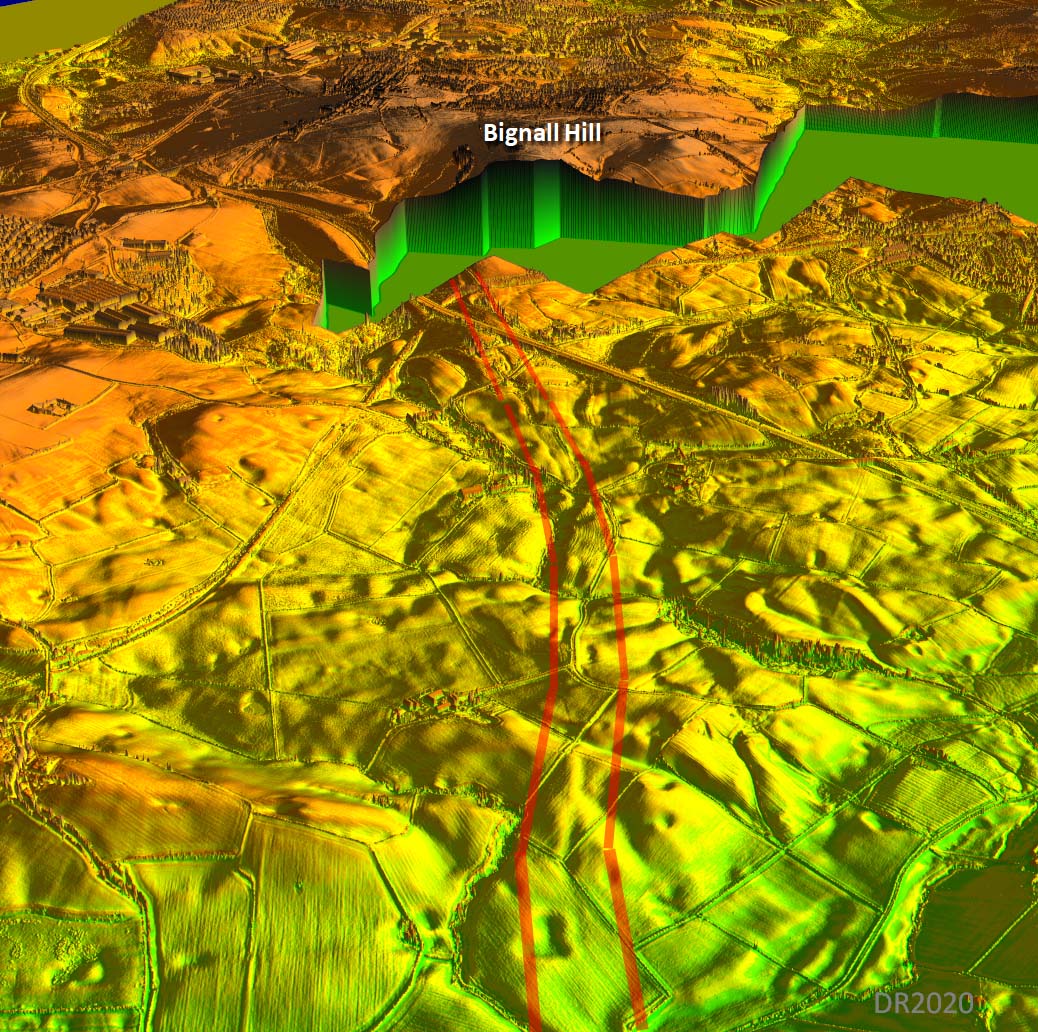
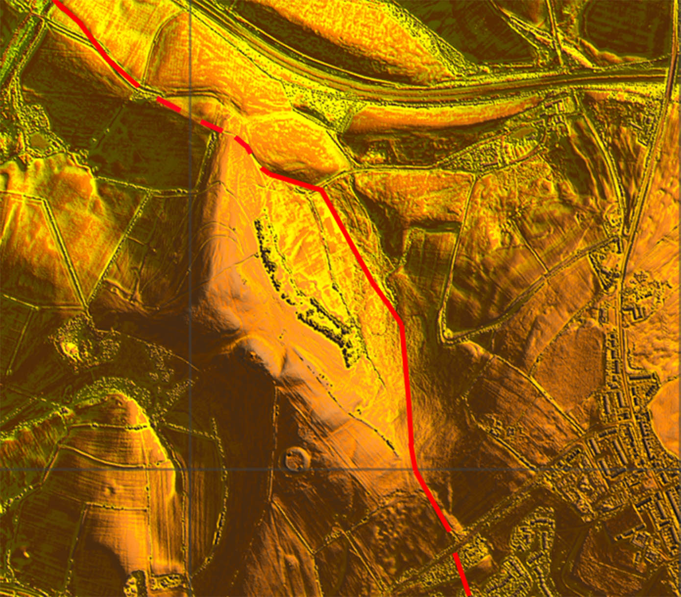
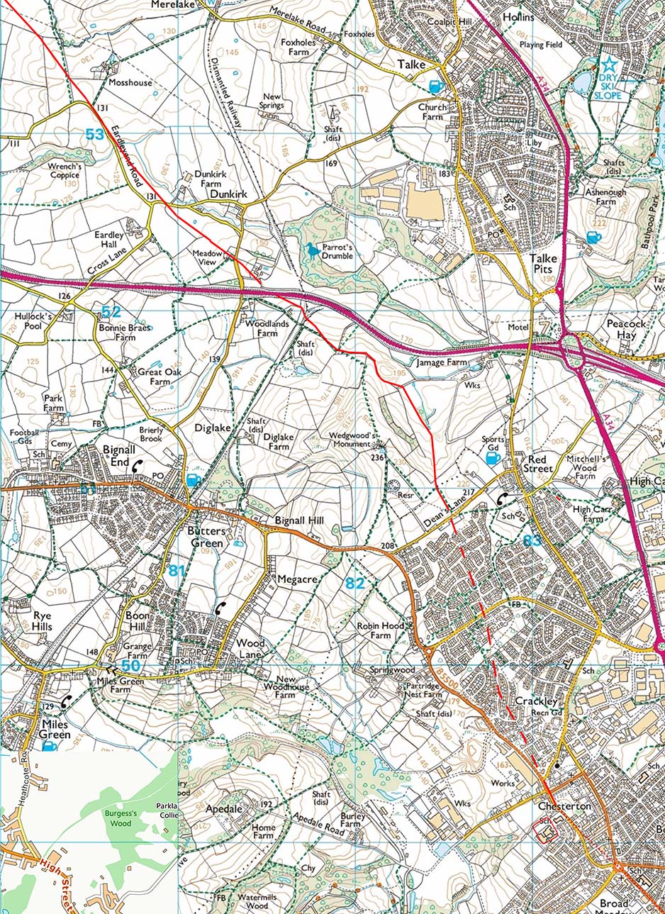
Bignall Hill & Wedgwood's Monument - Lidar & Route Map The direct route approached Chesterton fort along the ridge of high ground around Wedgwood's Monument. The latter would have been a very logical position with excellent view ahead to set out the alignment to Middlewich - assuming it was set out south to north.. With the release of Series 2 lidar we now have the route across Bignall Hill/Wedgwood Monument. Red Street would appear to be a clue but it is slighly off line but must have been named after the road. |
Click for larger view |
 |
3D Oblique Lidar Image - ascent to Wedgwood's Monument/Bignall Hill The ascent towards Wedgwood's Monument is clear and certain in this oblique Lidar image. |
Click for larger view |
 |
Lidar - Bignall Hill & Wedgwood's Monument There has clearly been much disturbance since Roman times but the route show is probably close to correct. |
Click for larger view |
 |
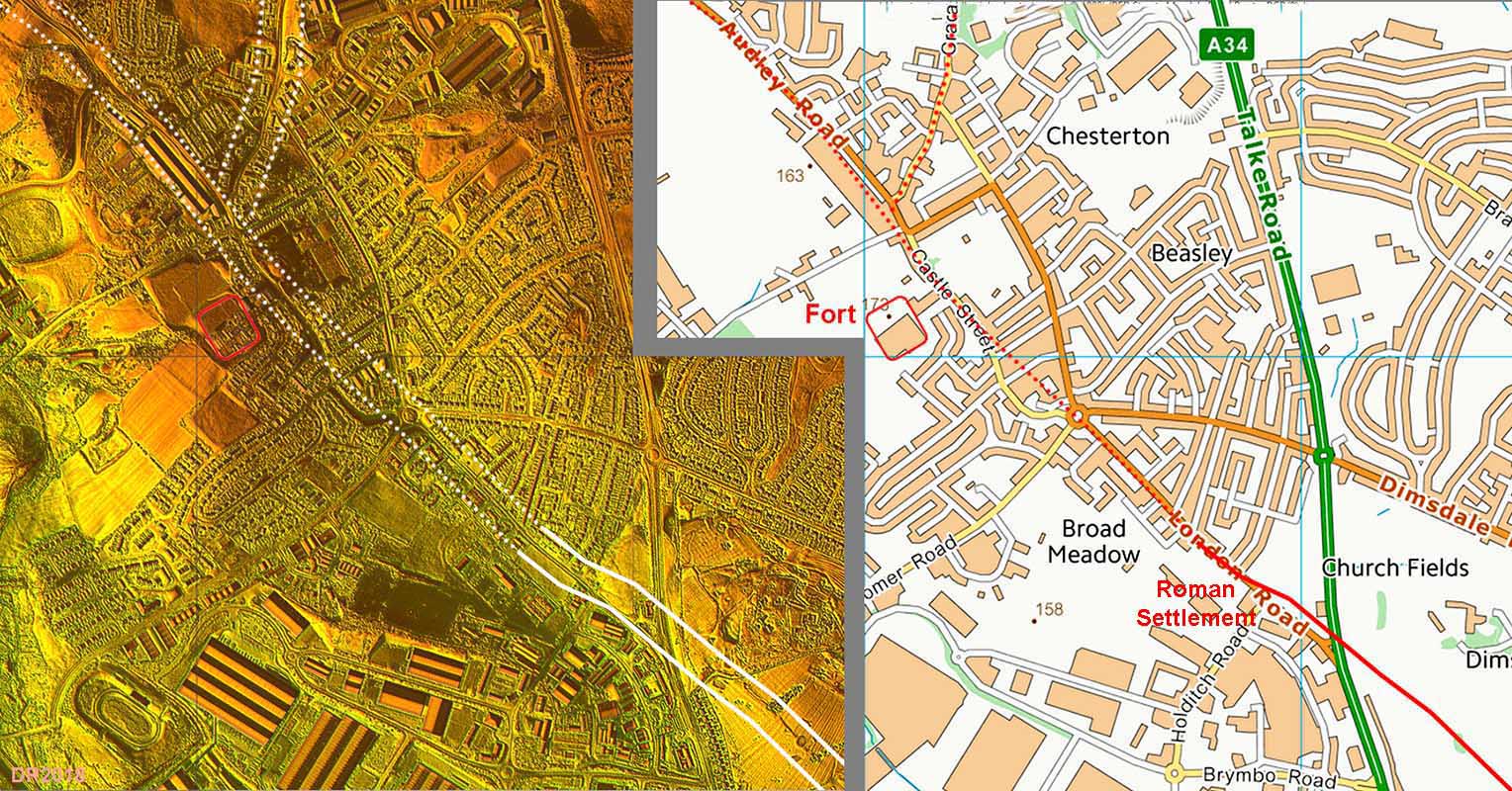
Chesterton - Lidar Image and Route Map The route was investigated beyond Chesterton Fort to see if its alignment would offer a clue as the route in from Middlewich. It probably does indicate that London Road and Castle Street are close to the Roman line so Audley Road could well be the line from Middlewich. Holditch appears to have been an important road-side settlement with several significant buildings. |
Click for larger view |
 |
Route Maps |
||
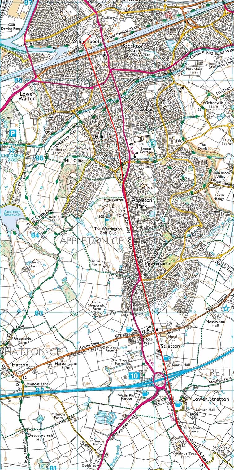
Wilderspool to Northwich - Map 1 |
Click for larger view |
|
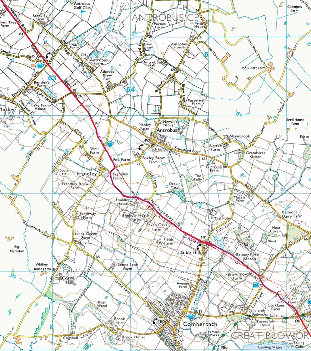
Wilderspool to Northwich - Map 2 Antrobus |
Click for larger view |
|
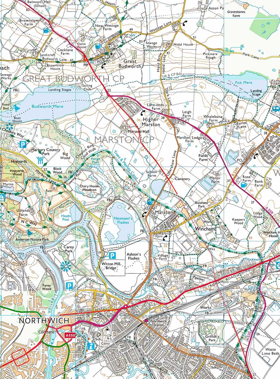
Wilderspool to Northwich - Map 3 Great Budworth |
Click for larger view |
|
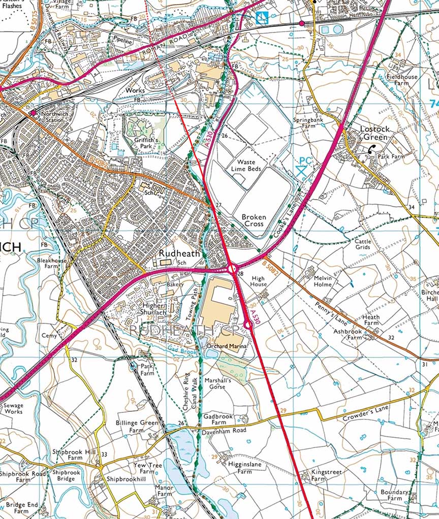
Northwich to Middlewich - Map 4
|
Click for larger view |
|
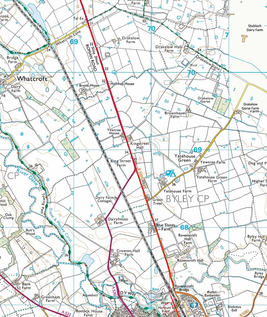
Northwich to Middlewich - Map 5 Kingstreet Hall
|
Click for larger view |
|
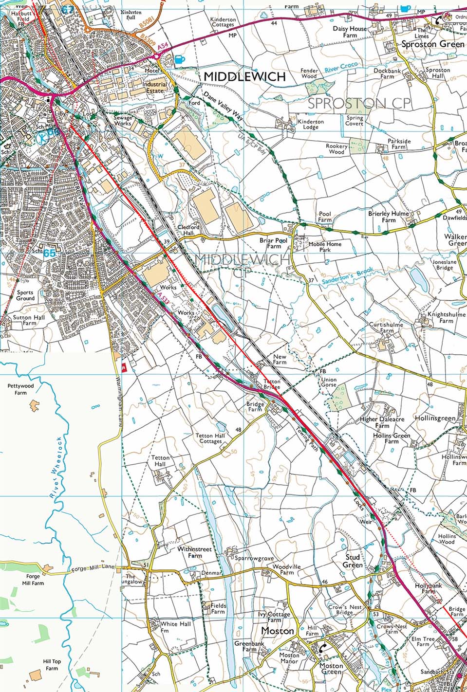
Middlewich to Chesterton - Map 6
|
Click for larger view |
|
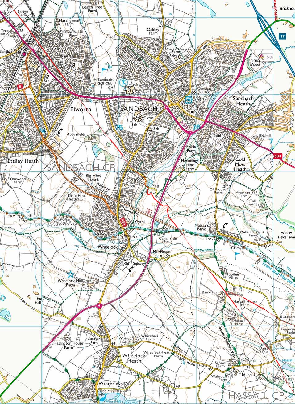
Middlewich to Chesterton - Map 7 Sandbach |
Click for larger view |
|
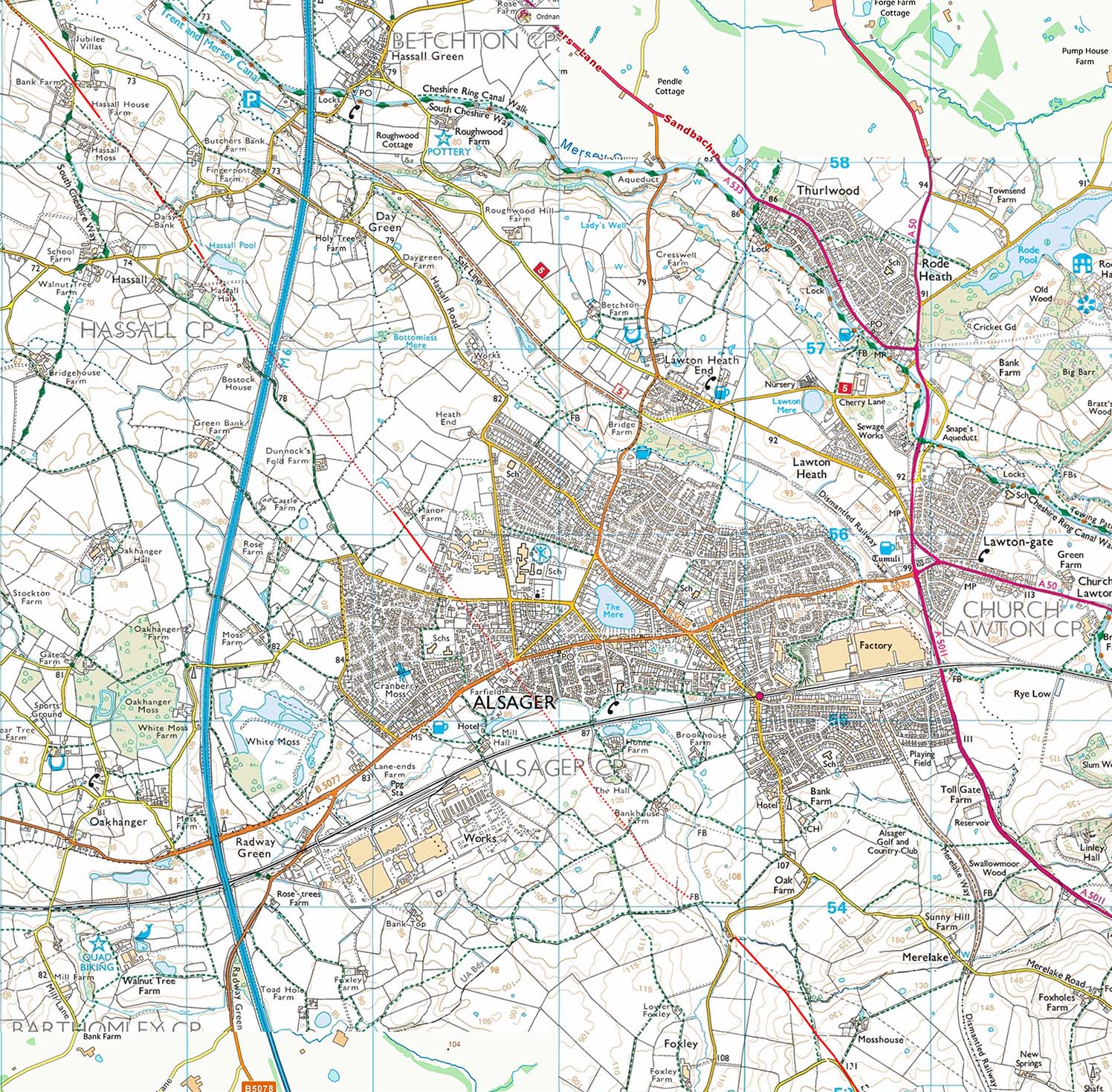
Middlewich to Chesterton - Map 8 Alsager |
Click for larger view |
|
Middlewich to Chesterton - Map 9 Chesterton - alternative routes over Bignall Hill are shown. |
Click for larger view |
|
|
|
|
Last update: August 2023 |
© David Ratledge & Neil Buckley |