 |
The Roman Road from Church Brough to Kirkby Thore, Margary 82The line of this road is well recorded on modern mapping except for the first few miles from Bough. Beyond Warcop, It is never very far from the A66 which is clearly derived from it.
This road is part of the Stainmore Road from York and it used to be thought it was aiming for Brougham but, as can be seen from the map, it is more aligned on Old Penrith but more of this later..
|

Route Map - Brough Leaving the vicinity of the fort the Roman line is represented by the existing track from Swindale beck heading up towards the A66 at Bullestone Bridge Beyond Flitholme Bride the A66 and the Roman diverge near Brough Hill. |
Click for larger view |
 |
Lidar Image Traces are somewhat intermittent so it is really joining the dots of this first stretch. |
Click for larger view |
 |
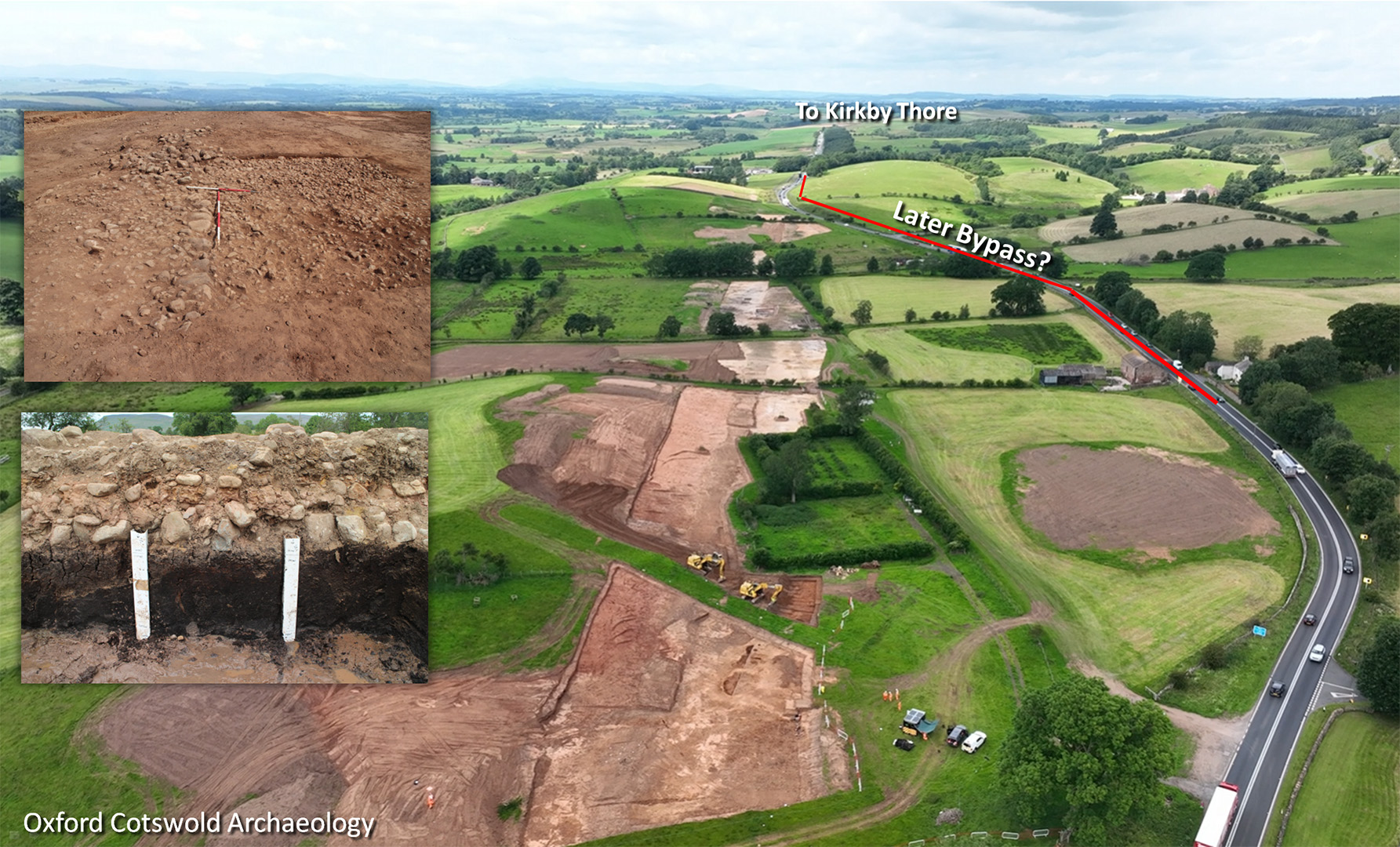
Route Map - Warcop There appear to be two routes for the route at the "Warcop Chicane". One direct and one presumably a later diversion around the boggy area. UPDATE 2026: Excavations by Oxford Cotswold Arcahaeology exposed the direct route - see below. |
Click for larger view |
 |
Lidar Image The two options for the Chicane can be made out so there were probably two routes in Roman times. |
Click for larger view |
 |
Wildboar Hill, Warcop - Excavations by OCS As part of the A66 upgrade, Oxford Cotswold Archaeology (OCA) carried out rescue excavations prior to the roadworks. This is a case of the new road returning to the original Roman line after nearly 2000 years! The cross-section through the road (lower inset) shows the road built on peat! Not advisable. This wet area was probably later bypassed by the Romans and a second route around the bog constructed. There is some evidence for this (in Lidar) at the far end in this view shown in red. The current A66 very wisely avoids the boggy area too. Images copyright OCA.
|
Click for larger view |
 |
Lidar Image - Appleby Fortlet Just after passing Appleby, there are the clear signs of a small Roman fortlet. The location is rather close to Kirkby Thore fort so the spacing is a bit odd. |
Click for larger view |
 |
Lidar image - Crakenthorpe Roman Temporary Camp One of the best surviving temporary camps in our area despite the modern A66 passing through the middle of it. It is assumed to be from the campaign of Quintus Petilius Cerialis around 70AD. Perhaps 10 entrances are visible and these are protected by external traverses or tituli. The north-eastern side and probably also the south-eastern side seem to have entrances at a regular spacing of around 60 metres. The camp is aligned with the Roman road where you have expected the camp to have pre-dated the road. Perhaps the campaign route and the later permanent road share one and the same period here. |
Click for larger view |
 |
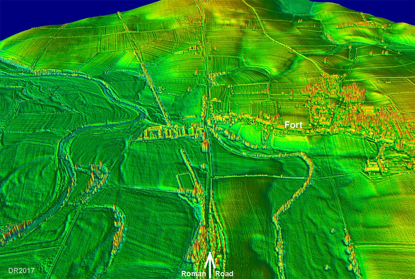
3D Lidar Image - Kirkby Thore Looking along the line of the road towards the north-west. The A66 marks the route. Kirkby Thore was actually an important cross roads with a road coming in from Low Borrowbridge and one heading off to Alston (the Maiden Way). |
Click for larger view |
 |
|
|
|
Return to Cumbria Roman Roads homepage Last update: February 2026 |
© David Ratledge |