|
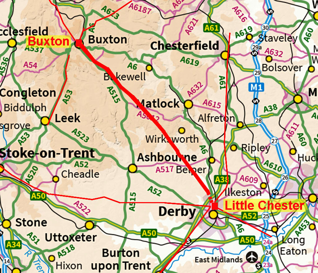
The Roman Road from Little Chester to BuxtonMargary Number: 71aDistance: 31 miles Heading south-east from Buxton over the limestone uplands is a very well-known and direct Roman road aligned apparently on Little Chester, Derby. It is locally known as “The Street” and on the limestone uplands it has survived extremely well and can be traced as far as Longcliffe near Brassington. Beyond Longcliffe, two suggested options for the route divide. Did the Street turn left for Wirksworth or carry straight-on? A two hundred year old puzzle. Probably the most recent articles on the two options are those by Wirksworth Archaeology Society and by Adrian Farnsworth & Paula Whirrity. The former are strong protagonists for a route via Wirksworth and the Derwent Valley. Farrnsworth/Whirrity suggested possible options for two direct routes as far as Kirk Ireton. See references at the bottom for further details. Ivan Margary was more circumspect and hedged his bets somewhat. He described a route via the Derwent valley and hence Wirksworth (he was following the road in the opposite direction). However, he cautioned this with “if a directly aligned road was not made.” His caution was well placed. We can now be absolutely certain that Roman road 71a, The Street, did indeed follow a direct line to Little Chester. The Lidar evidence is overwhelming and unambiguous. Lidar has now found dozens of roads around the country with no digging required! So the 200 year old puzzle has at last been solved. Almost certainly associated with this road is the lost Roman site of Lutudarum. This is listed next to Derventio (Little Chester) in the Ravenna Cosmography and so must have been connected by road. It was one of the country’s major Roman lead mining sites. Lead pigs with the stamp of Lutudarum have been found in a wide variety of locations – many in Derbyshire including two at Carsington, four in Sussex and nine near Brough on Humber. The finding of this road, plus the other evidence, strongly suggests that Carsington is the site of Lutudarum (see later). Reference - Derbyshire Archaeological Journal, Volume 141, 2021 - The Roman Road between Little Chester and Longcliffe - David Ratledge. |
Historic Counties: Derbyshire Current Counties: Derbyshire HER: Derbyshire
|
|
|
|
|
|
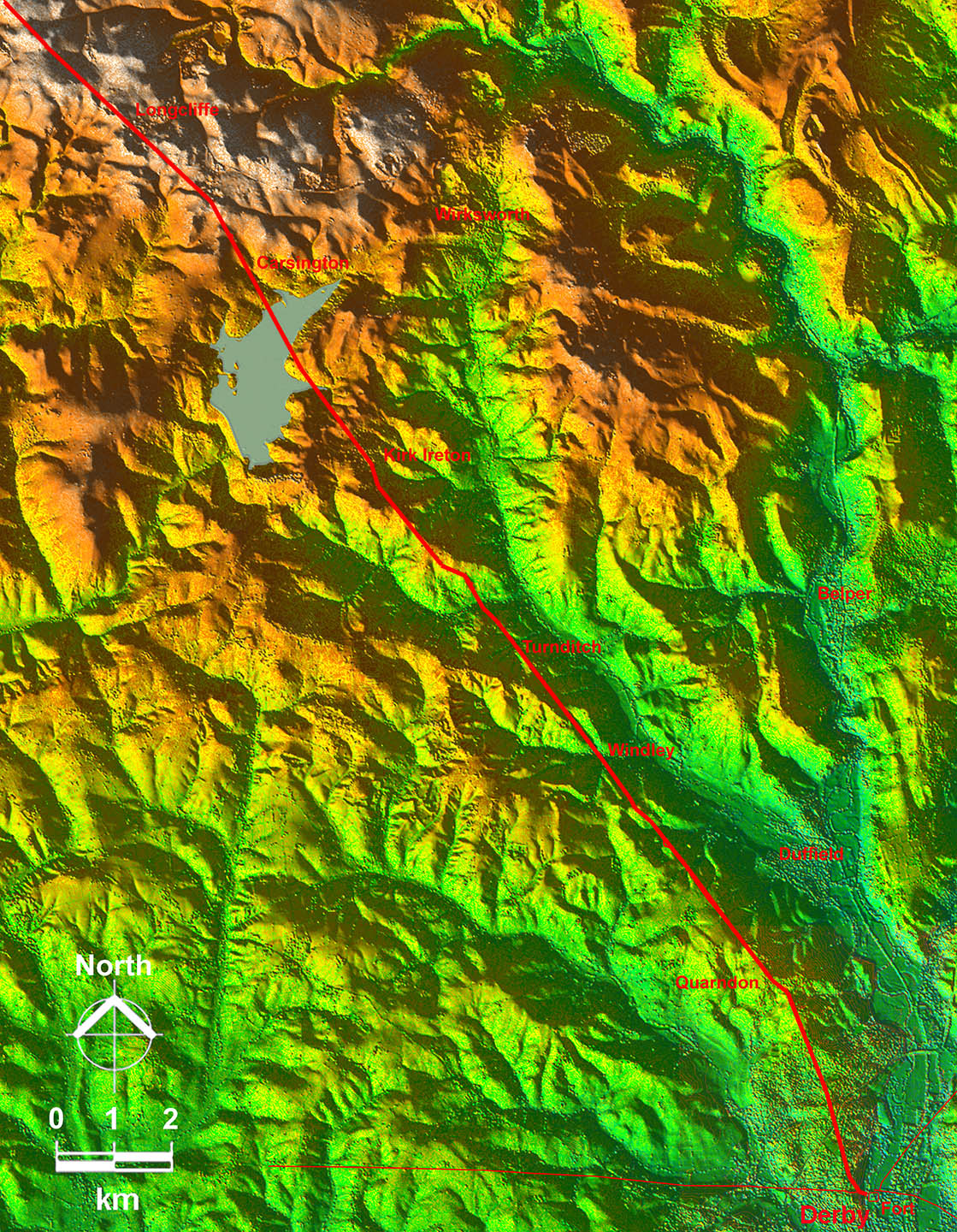
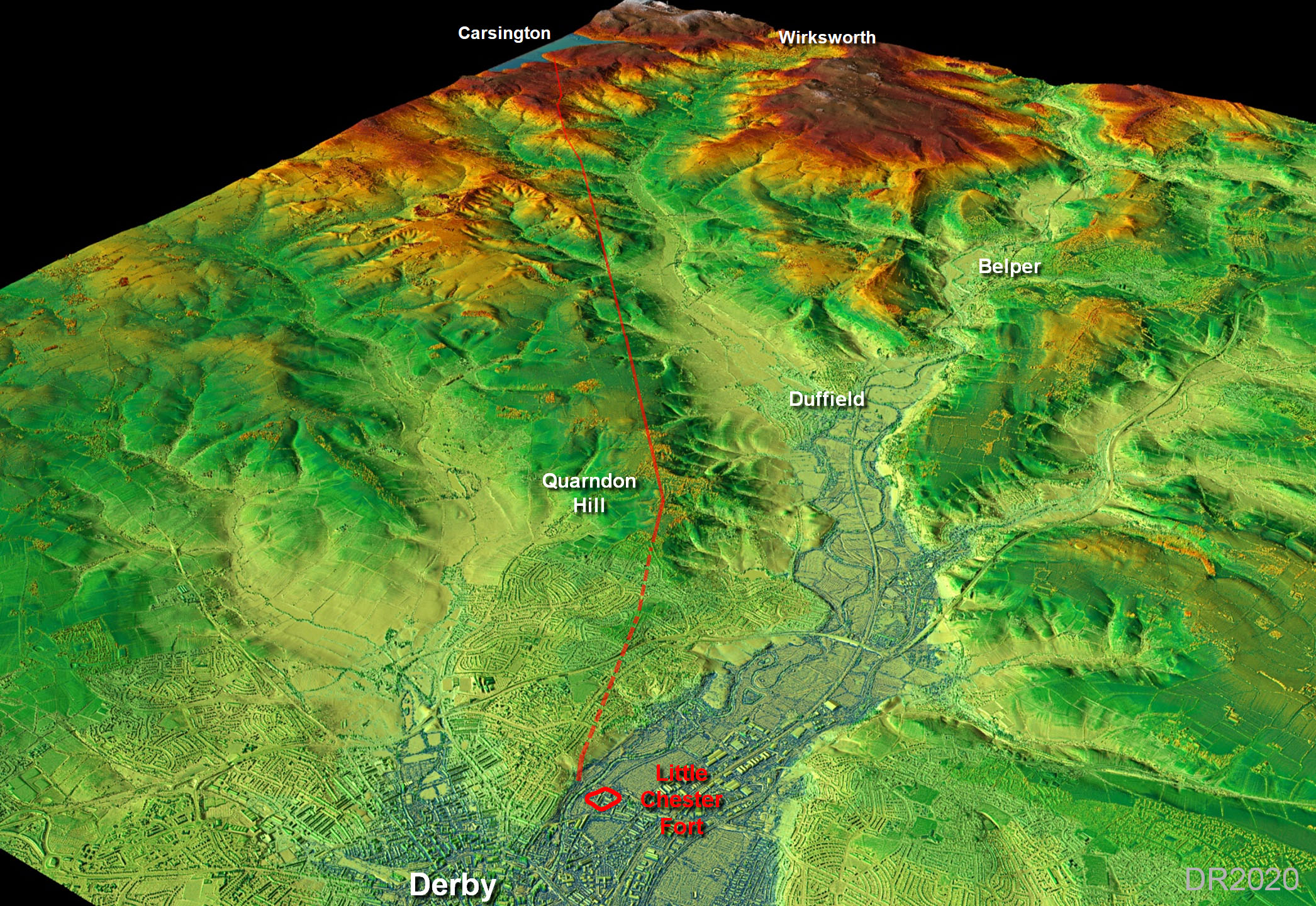
Lidar Image - Derby to Longcliffe How could anyone doubt it went direct to Little Chester? Obvious now but elusive until the advent of Lidar! Superb Roman engineering to create such a straight alignment despite having to cross the many side valleys of the main Ecclesbourne Valley. Only a single small deviation at Rakestones-Kirk Ireton was needed. |
Click for larger view |
 |
|||||||||||||||
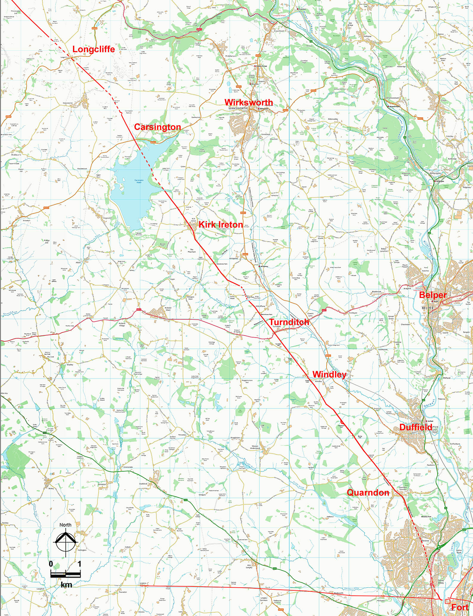
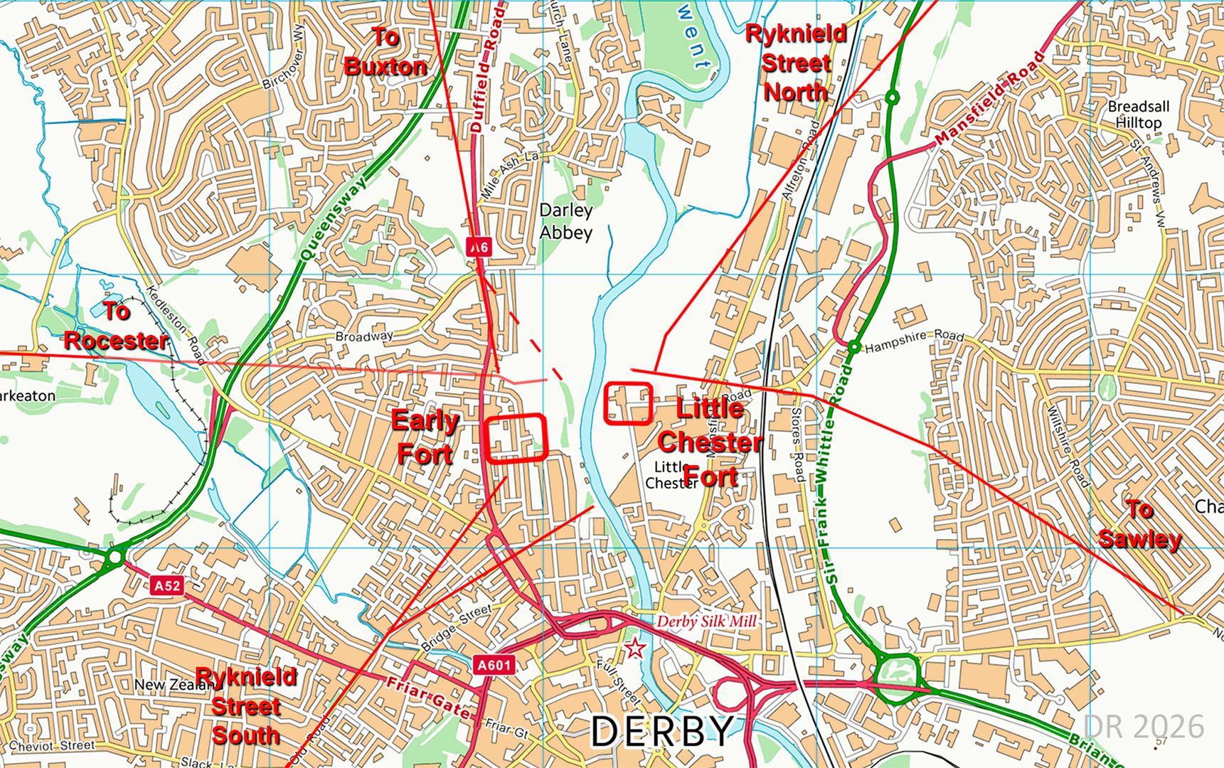
Route Map - Derby to Longcliffe Map equivalent to the above. The key locations quoted in the description below are shown on this map.The Roman site at Carsington is now under the water of the reservoir. |
Click for larger view |
 |
|||||||||||||||
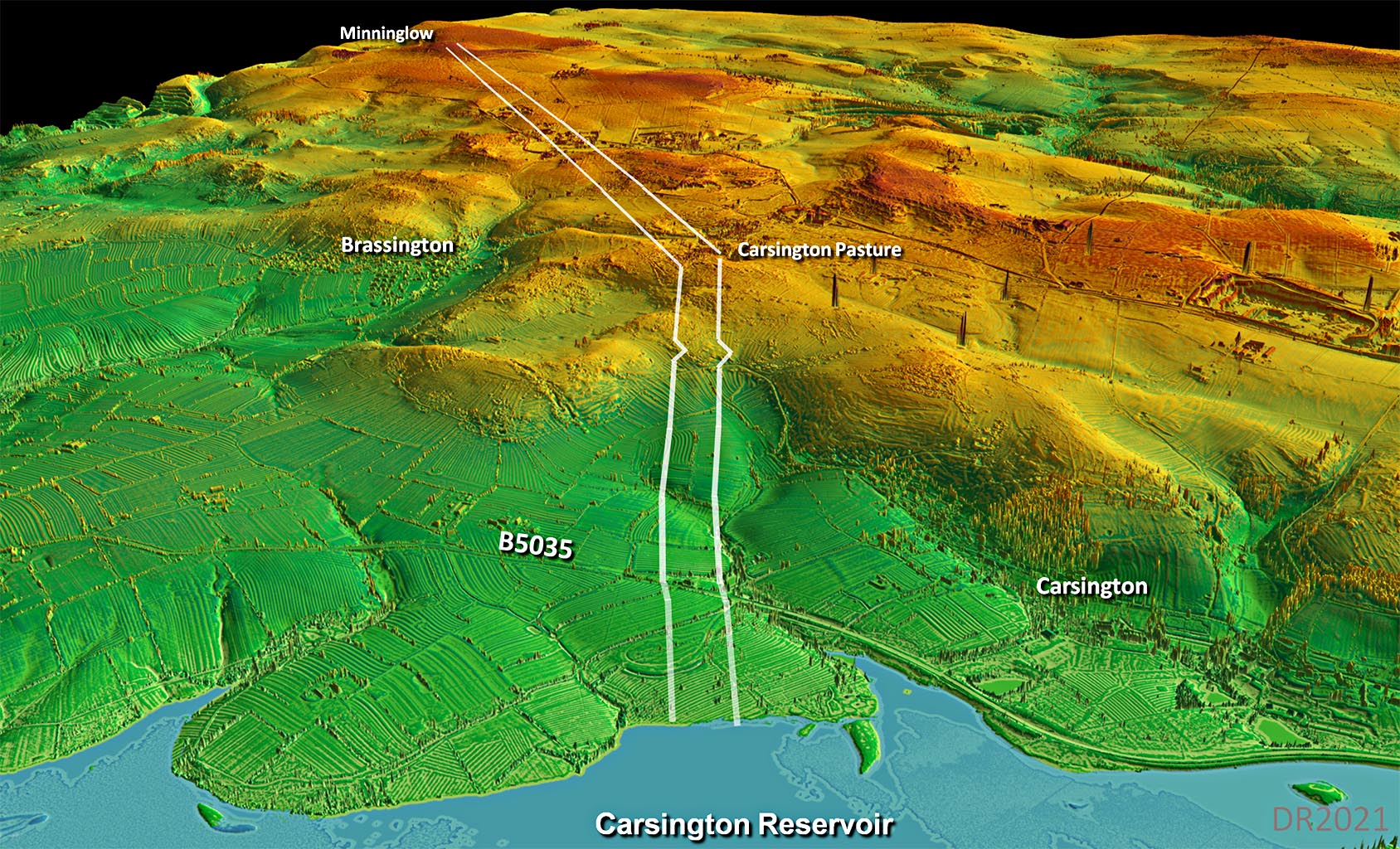
Oblique 3D Lidar Image - Route to Carsington Reservoir The strategy was clearly to run along the west side of the Ecclesbourne Valley. The oft suggested alternative via the Derwent Valley and Wirksworth would have been considerably longer and crossed much more difficult terrain.
|
Click for larger view
|
 |
|||||||||||||||
Ordnance Survey First Edtion Map - Little Chester There is sufficient evidence to indicate the road was initailly set out from the early fort on the west bank in Derwent Park. Field boundaries and part of Duffield Road all align exactly with the original fort. It is likely that once the permanent fort on the east bank was established and a bridge over the Derwent constructed that a diagonal short-cut would have been introduced - see below.
|
Click for larger view
|
 |
|||||||||||||||
Route Map 1 We can now be very confident of the first section of our road aiming for the early fort. Once the permanent fort of Little Chester and the bridge was constructed then it is more than likel that the road was diverted down to the bridge (shown dotted). There is some lidar evidence for this. |
Click for larger view |
 |
|||||||||||||||
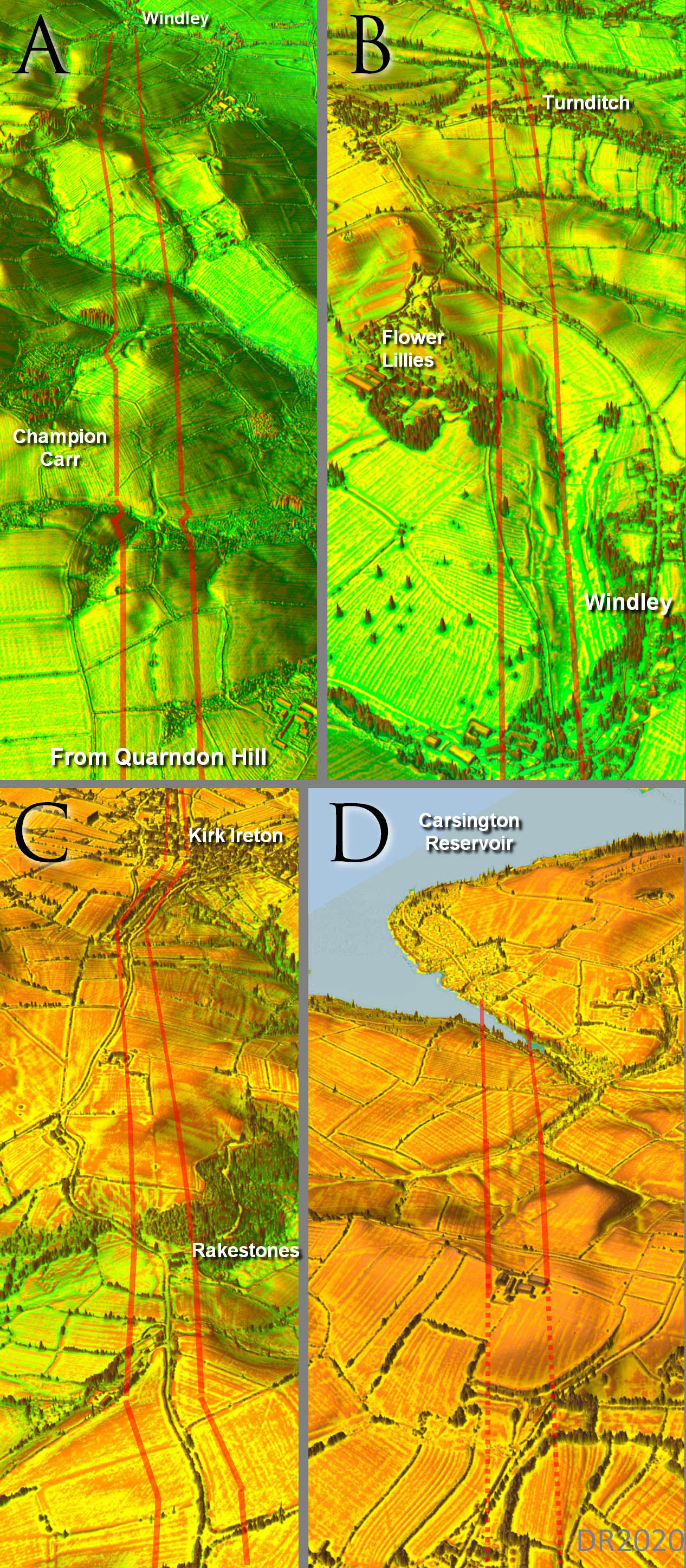
Oblique 3D Lidar Images - The Original Clues for the direct route Spotting the road was surprisingly easy and the section from Quarndon Hill (north west of Derby) heading in a straight alignment to Windley, a distance of about 3 miles, was found straightaway. It took another days work of varying the illumination angles in the LiDAR model to tease out the complete route to Carsington. Despite those side valleys it was amazingly direct.
|
Click for larger view |
 |
|||||||||||||||
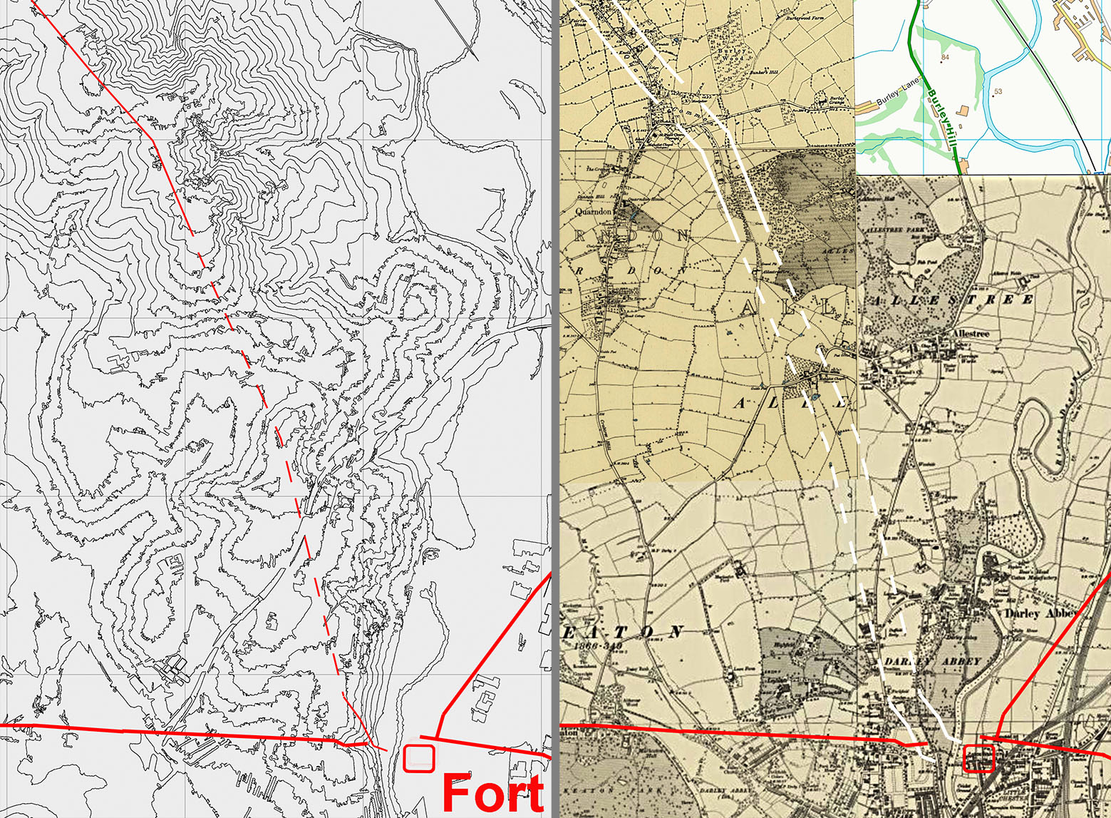
Contour Map & OS First Edition Map Short of someone digging up the road in their back garden here we are reliant on (intelligent?) guesswork. For this I used a contour map and the OS First edition mapping. The route shown is logical, avoiding valleys and keeping to the ridge that is now Woodlands Road. Quarndon Hill was obviously the setting out point for the main alignment to Carsington. I think we can be reasonably confident here. |
Click for larger view |
 |
|||||||||||||||
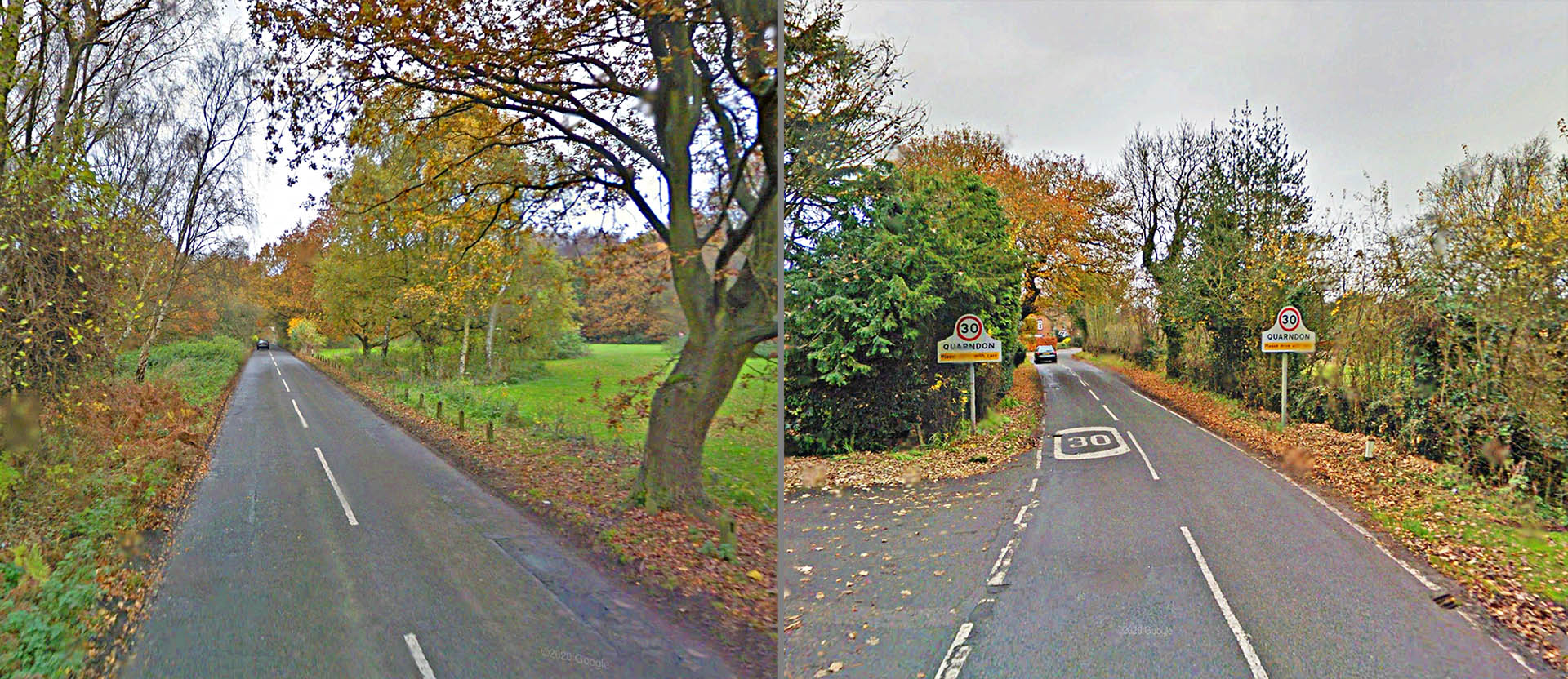
Woodlands Road, Quarndon We can be confident that Woodlands Road marks the route up the hill to Quarndon, it has all the necessary characteristics. See the 3D lidar image below which also confirms this. Images; Google Streetview |
Click for larger view |
 |
|||||||||||||||
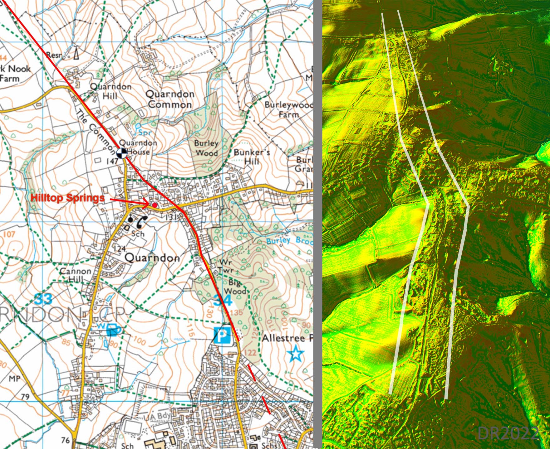
Route map and 3D DTM Lidar Image - Quarndon The route over Quardon Hill is somewhat subjective as development has covered any potential on the ground clues. However, studying the DTM Lidar 3D model (right) shows there is really only one option across the hill. There can be little doubt therefore as to the route the Roman road took. A slightly more direct route would have taken the road over a marshy spot previously known as Sulleys Field. Here water emerges from springs - marked as Hilltop Springs on the map. This would have been a logical place for the road to pass close too but not directly through it. Thanks are due to Professor Jonathan Powers, who lives locally, for this information.
|
Click for larger view |
 |
|||||||||||||||
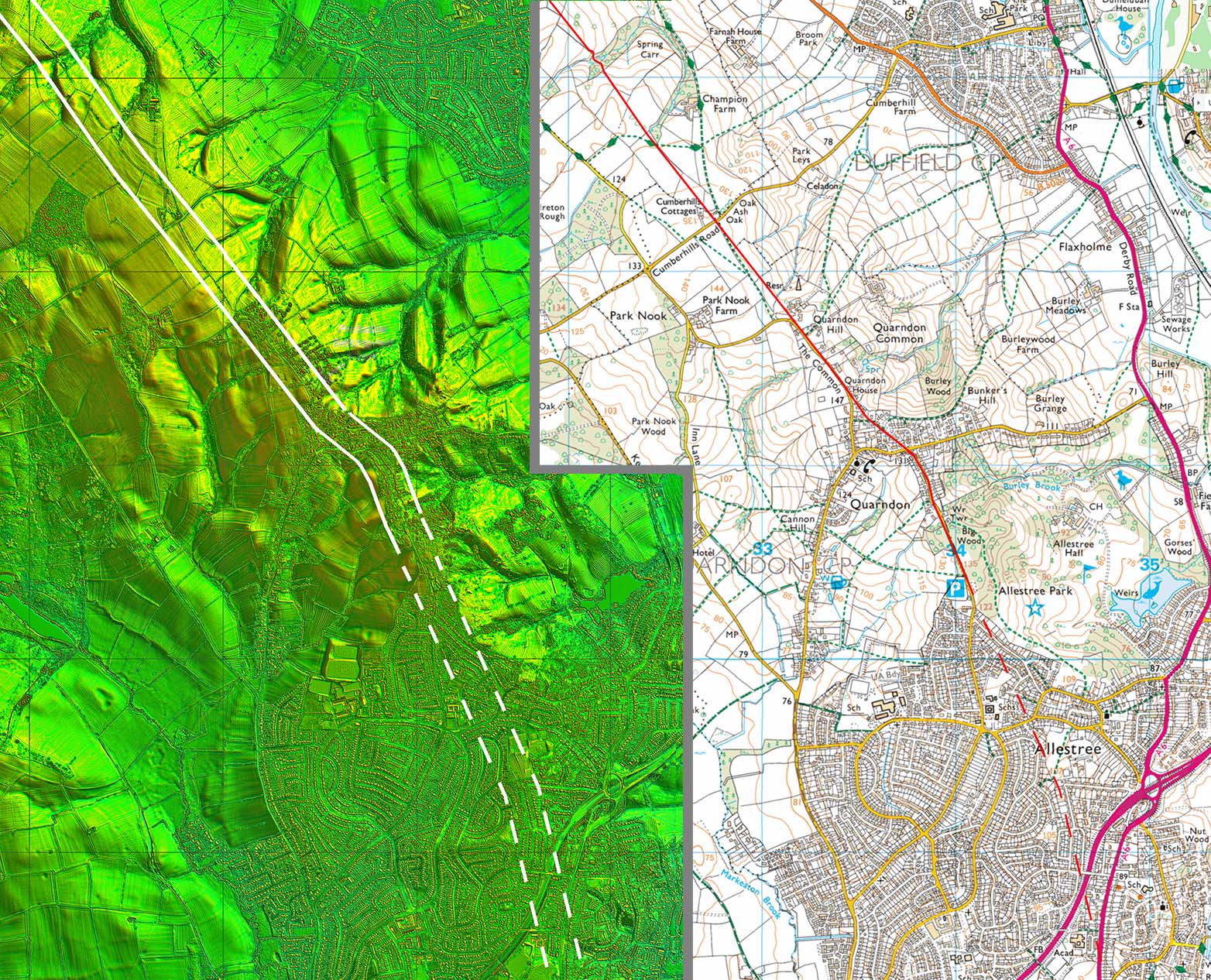
Lidar Image & Route Map 2 From Quarndon Hill then the Common marks the line and when the modern road swings off line then the first clues become visible in the fields (see clues above) plus there are plenty of them to dispel any doubt. A feature of this road, well the southern half that is, are the number of cuttings. To get a straight alignment, obviously a high Roman priority, then crossing the side valleys of the Ecclesbourne valley necessitated frequent earthworks. The advantage for us nearly 2000 years later is that cuttings survive rather well as they are much harder to plough out. There is an amazing sequence of them between Quarndon Hill and Turnditch. |
Click for larger view |
 |
|||||||||||||||
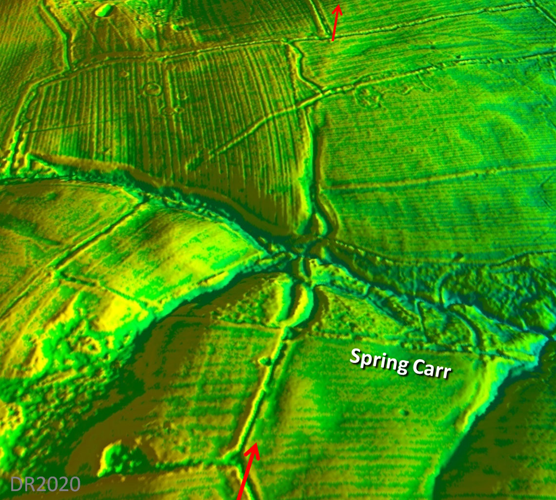
Oblique 3D Lidar Image - Spring Carr This is the first pair of cuttings for crossing the stream at Spring Carr. It appears that on both sides of the stream that there were curving zig-zags to ease the slopes. There is also evidence of direct routes but these appear abandoned/ cut off. |
Click for larger view |
 |
|||||||||||||||
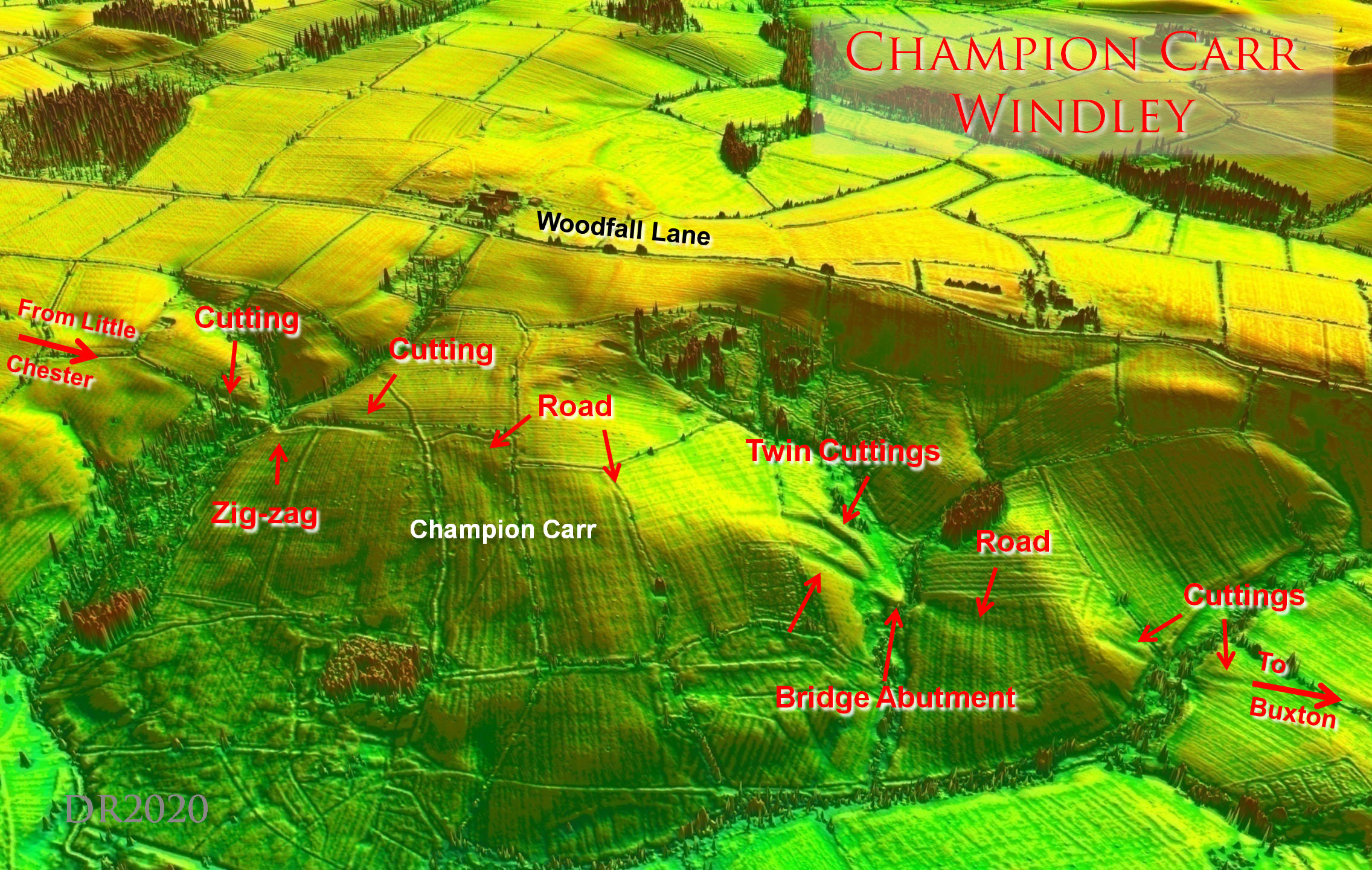
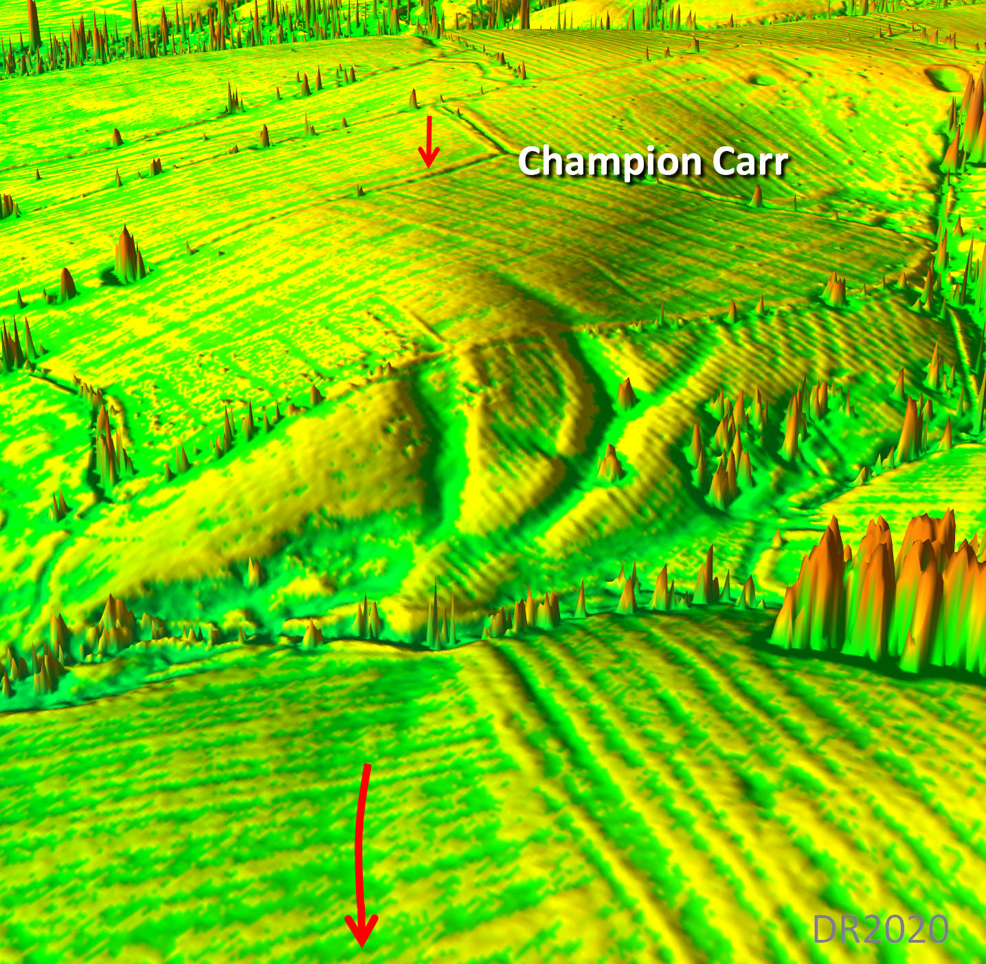
Oblique 3D Lidar Image - Champion Carr There are several clues leaving the Common but at Spring carr begins the series of cuttings to negotiate the several side valleys. The most amazing pair are at Champion Carr – twin cuttings for the descent to the stream. The twin cuttings are so spectacular that I make no excuse for having included two images of them (here and below). Another pair of cuttings follow on this fabulous stretch of road. |
Click for larger view |
 |
|||||||||||||||
Oblique 3D Lidar Image - Twin Cuttings One cutting is clearly on the direct line and the second, the curving one, obviously a relief route with reduced gradients. For the direct line the gradient was around 1 in 6 and for the curving relief route around 1 in 10. The 1 in 6 is common for Roman road inclines in the north but was it too steep for those heavy lead pigs coming from the Lutudarum mines? |
Click for larger view |
|
|||||||||||||||
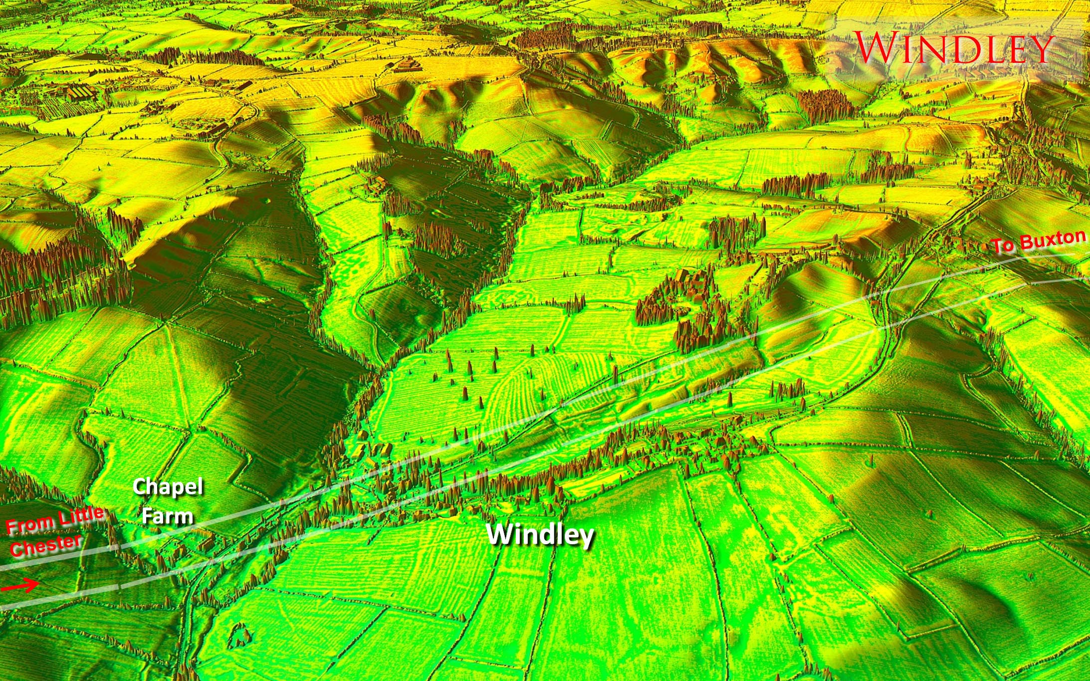
Oblique 3D Lidar Image - Windley The main alignment seems to have been selected to make use of a natural valley for the ascent from Windley. Even so it appears considerable work was needed to construct the road on side sloping ground. A long revetment would have been needed and this has survived albeit much disturbed now. According to Dodd & Dodd (Peakland Roads and Trackways, 1974) a fifteenth century deed from WIndley references "Le Strete". |
Click for larger view |
 |
|||||||||||||||
Lidar Image & Route Map 3 WIndley Valley seems to have been a key target for the alignment. My guess is the setting out points were Quarndon Hill and the hillock just south of Blind Lane at Winson Farm. The 3D Lidar model indicates they were inter-visible. |
Click for larger view |
 |
|||||||||||||||
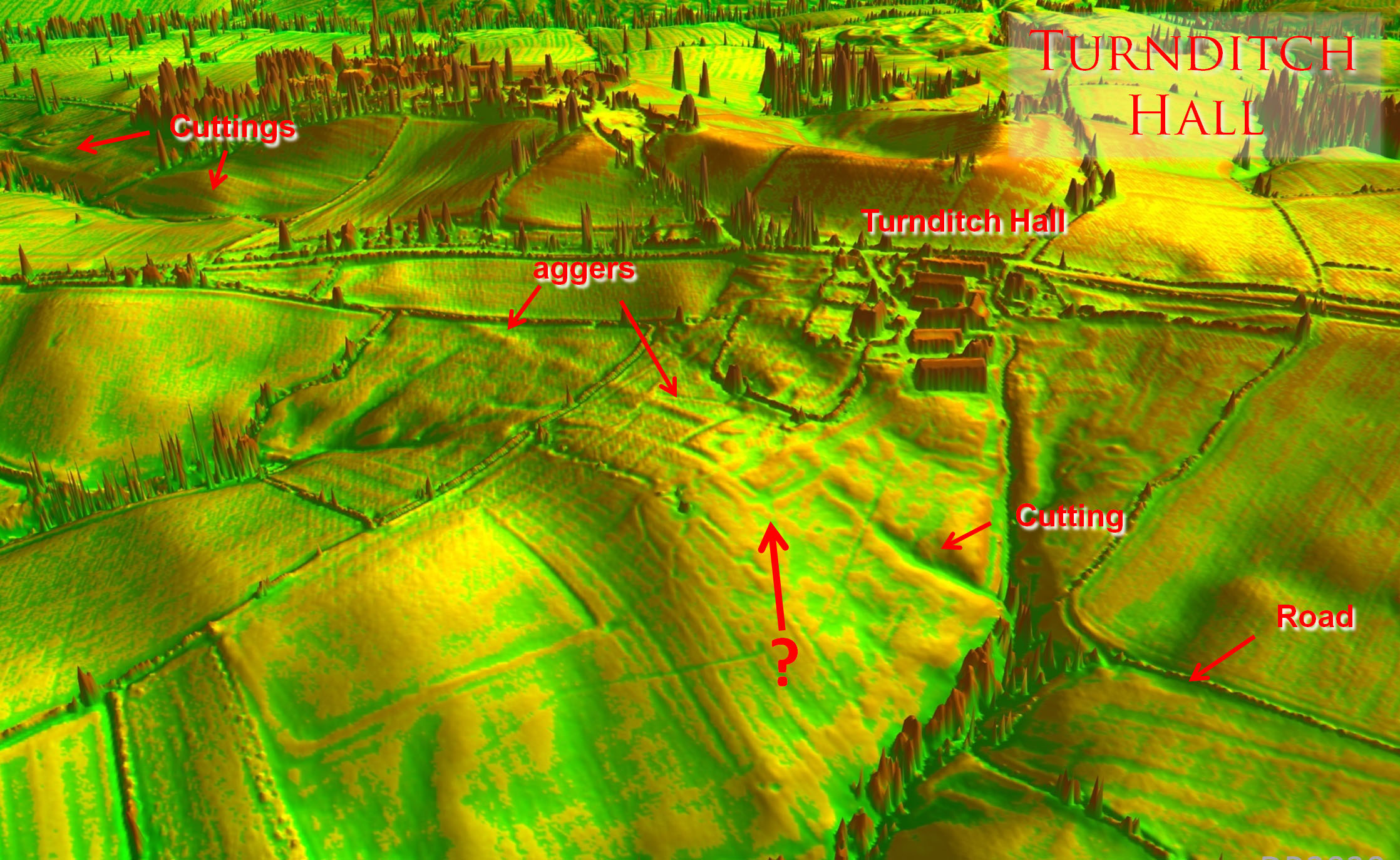
Oblique 3D Lidar Image - Turnditch Hall We are now approaching the high ground of Turnditch but first passing Turnditch Hall there is stretch of surviving aggers – a rarity so far, no doubt due to ploughing. There is a feature astride the road there but opinion is divided on what it may be. |
Click for larger view |
 |
|||||||||||||||
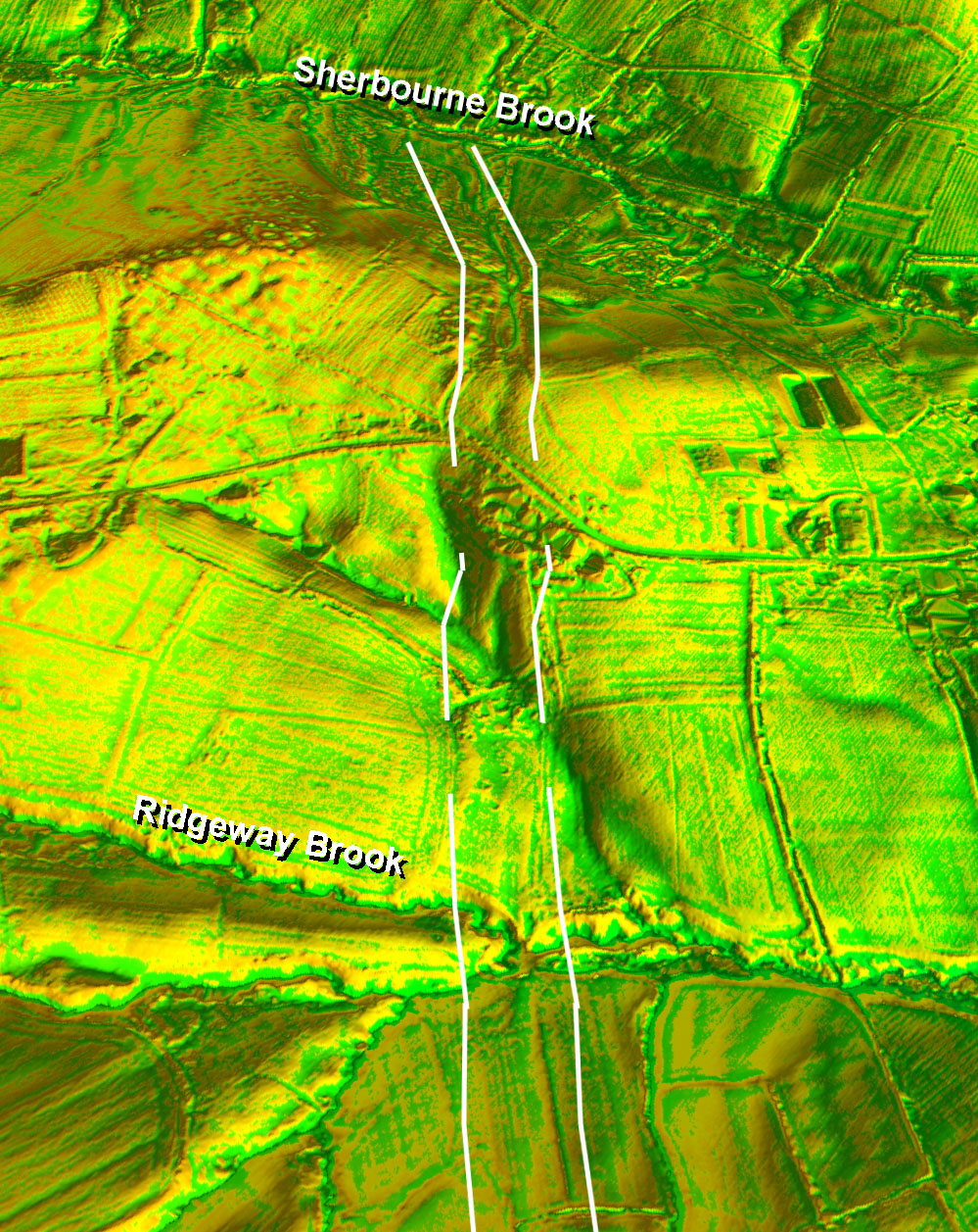
Oblique 3D DTM Lidar Image - Ridgeway Brook to Sherbourne Brook We are looking down the line of the road from just beyond Turnditch. The road has a tricky side stream of Ridgeway Brook to negotiate. To do this the Roman surveyor chose head to high ground via a zig-zag cutting ascent which is clearly visible in the centre of the image. The apparently easier route down the little ravine to the left is very boggy so they avoided it - sensible engineering. |
Click for larger view |
 |
|||||||||||||||
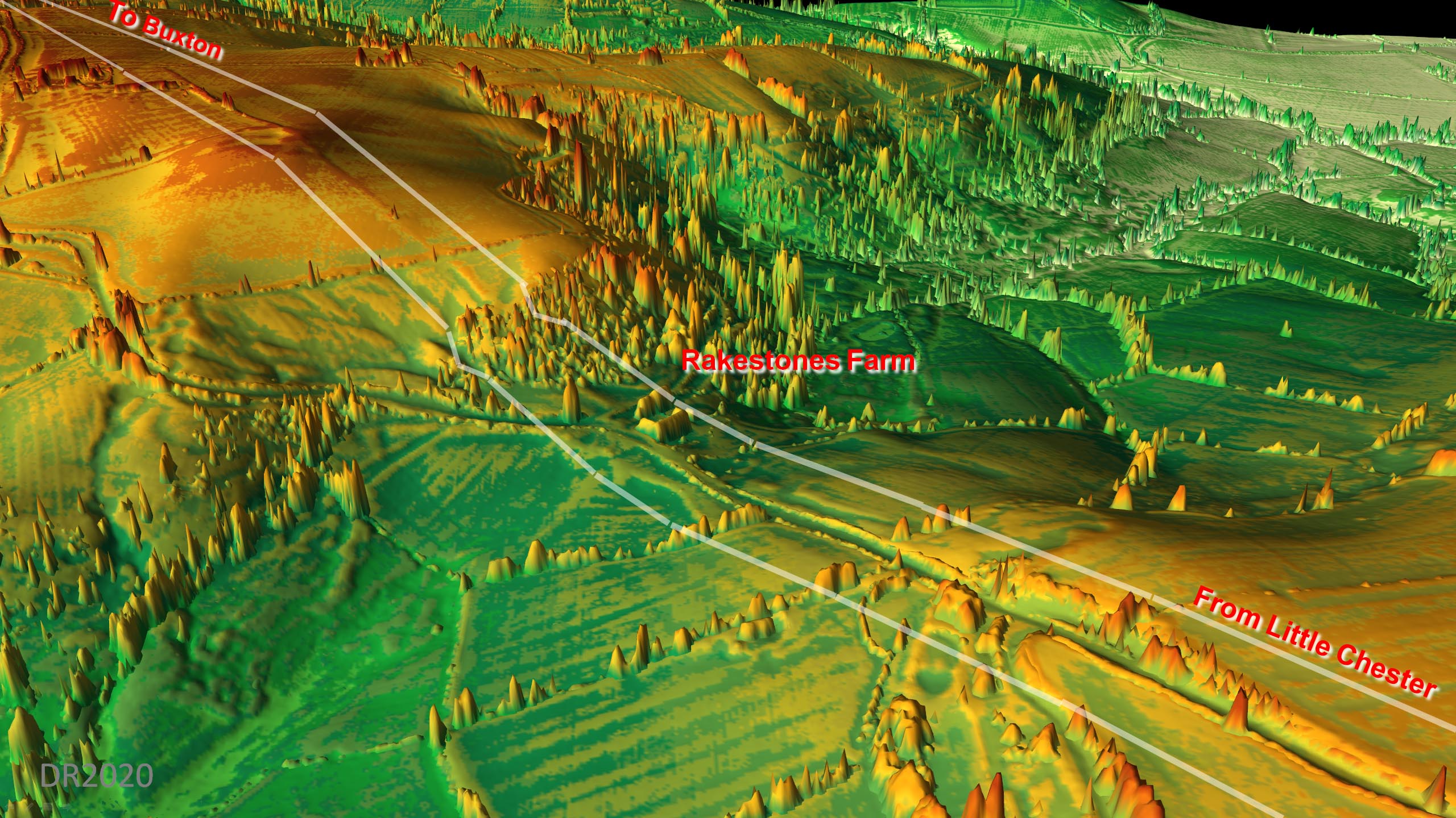
Oblique 3D Lidar Image - Rakestones It is obvious in this oblique LiDAR view just why the road aimed for this spot at Rakestones. It a natural watershed ridge linking the two high grounds together. There was a small zig-zag in the woods. |
Click for larger view |
 |
|||||||||||||||
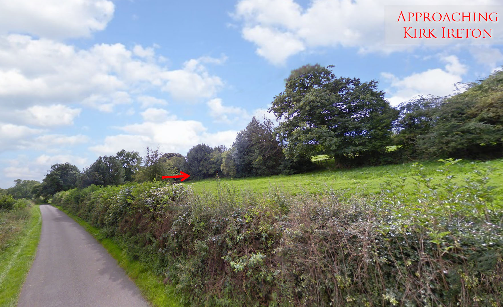
Nether Lane, Kirk Ireton Approaching Kirk Ireton and alongside Nether Lane the Roman line follows the row of trees visible in the field. The road is angling here to return to the main alignment which it re-attains through Kirk Ireton Google Streetview. |
Click for larger view |
 |
|||||||||||||||
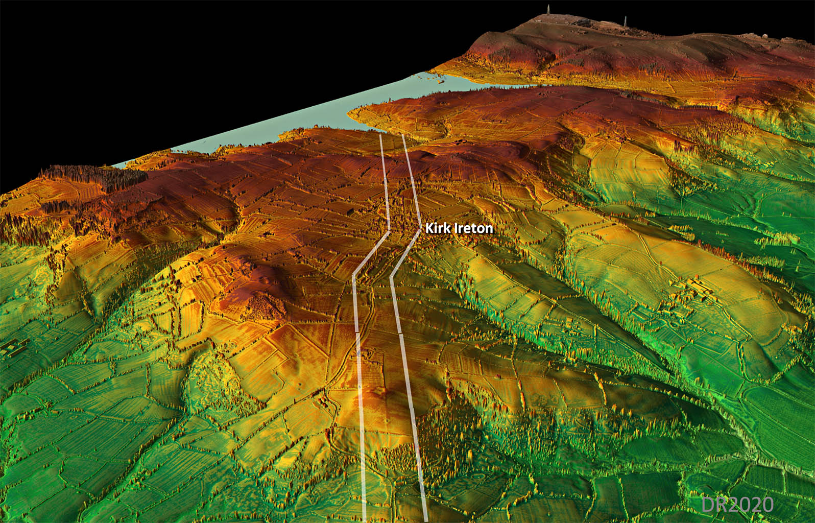
Oblique 3D Lidar Image - Kirk Ireton After the deviation at Rakestones, the main alignment is regained at Kirk Ireton and continues all the way to the reservoir. |
Click for larger view |
 |
|||||||||||||||
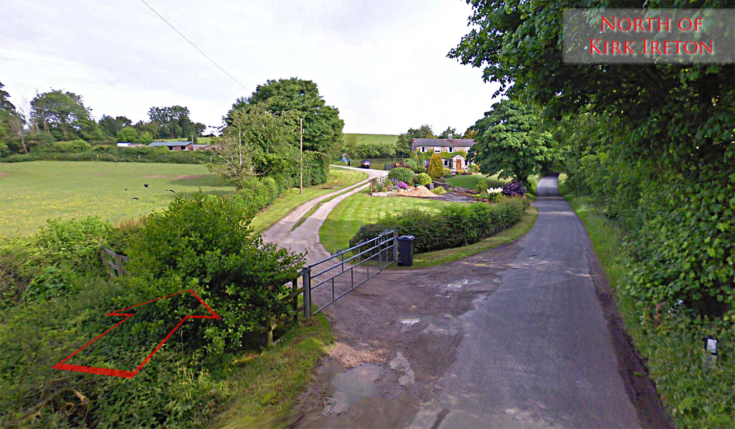
Moor Lane, Kirk Ireton North of Kirk Ireton the Roman line crosses Moor Lane at a shallow angle. Behind us hedgerows mark the line and ahead a hedge and track preserve the route. It is heading up to the high ground at Winson Farm which was one of the primary setting-out points. Google Streetview. |
Click for larger view |
 |
|||||||||||||||
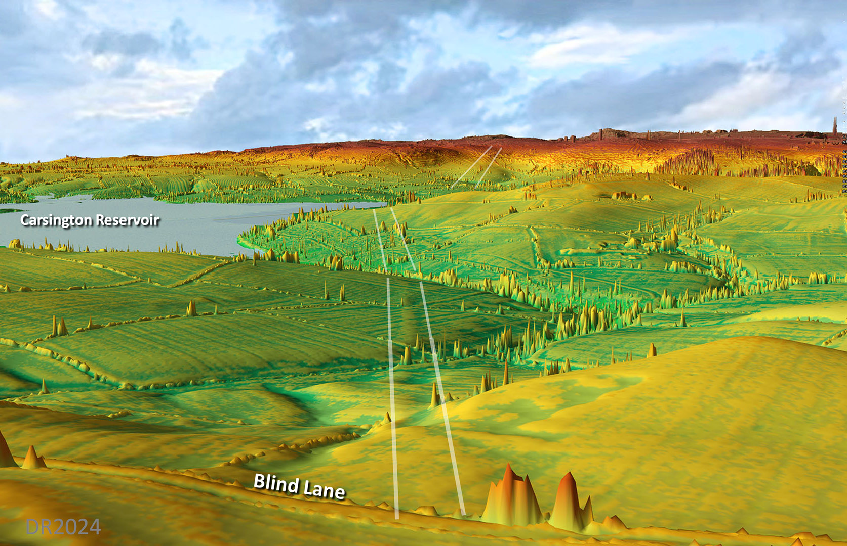
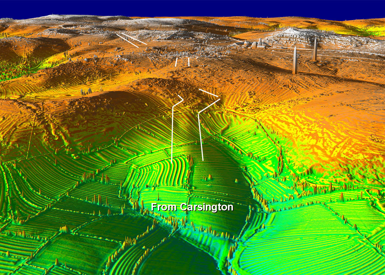
Oblique 3D Lidar Image - Carsington Reservoir The last visible lidar trace before the road disappears under the reservoir - but it is a good one. A very prominent agger heading for what is now a flooded valley of the reservoir. During the reservoir construction works significant Roman remains were revealed plus there were earlier finds of 2 of those lead pigs stamped with the mark of Lutudarum. |
Click for larger view |
 |
|||||||||||||||
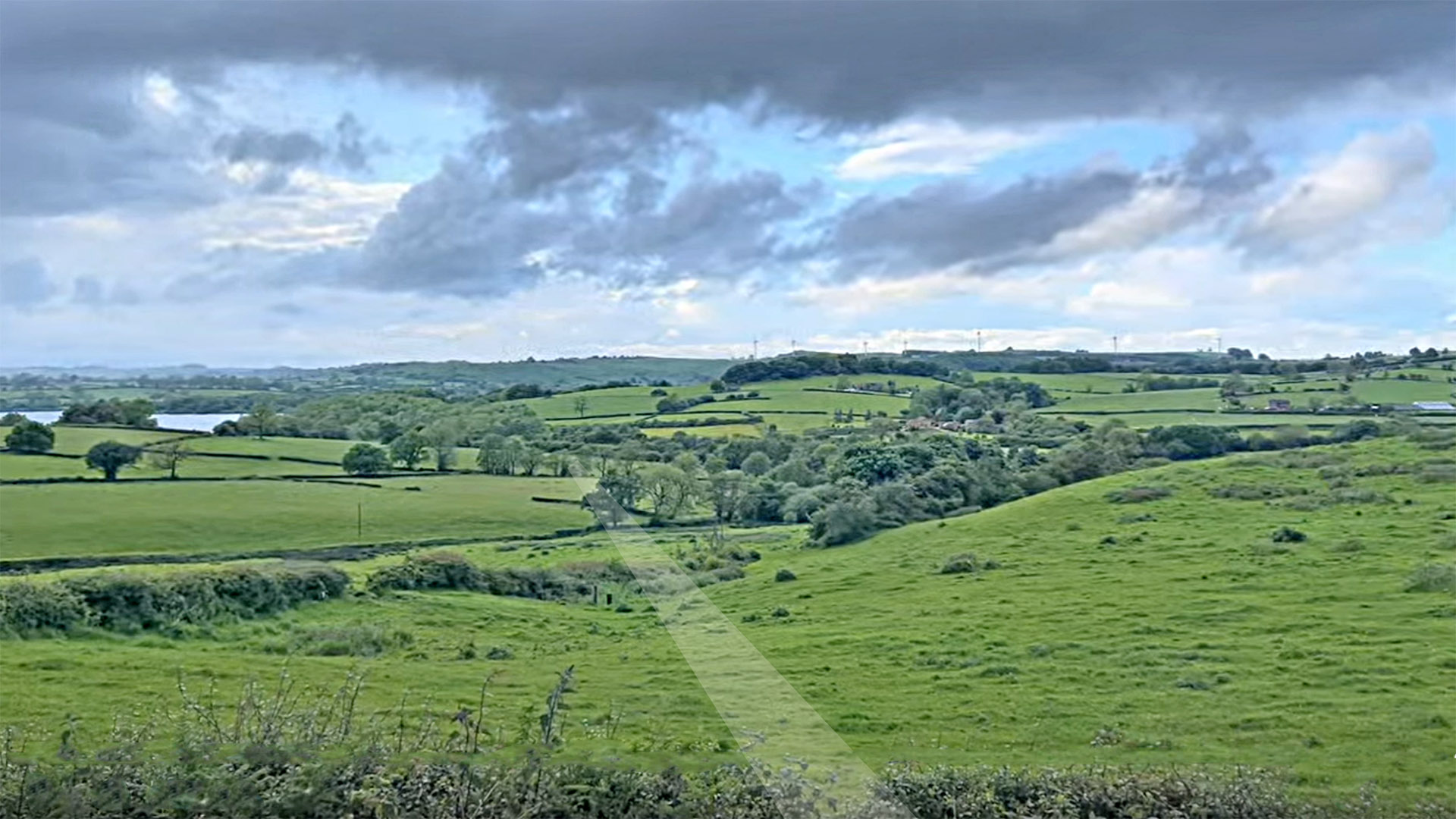
View from Blind Lane towards Carsington Reservoir The equivalent real ground level version of the above. Not quite as obvious as the Lidar but that is normal. Image: Tom Housley |
Click for larger view |
 |
|||||||||||||||
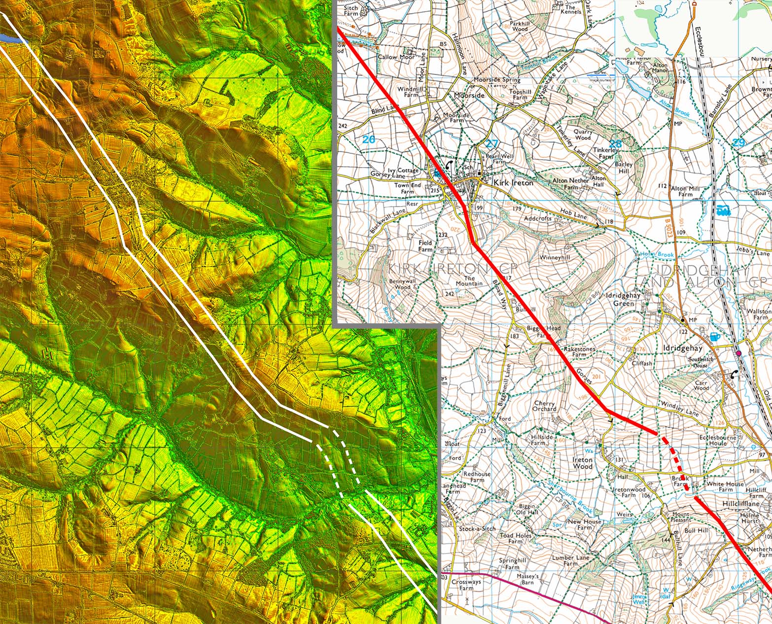
Lidar Image & Route Map 4 Evident in this map is the section off the main alignment. This was selected to follow that ridge at Rakestones and it returned on line at Kirk Ireton. |
Click for larger view |
 |
|||||||||||||||
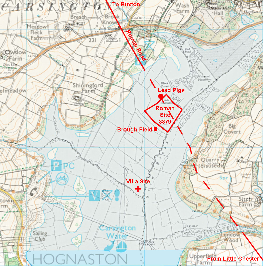
Carsington Roman Site Map - Lutudarum We can now interpolate the line of the Roman road across the reservoir with reasonable confidence. The location of the various Roman sites recorded in Derbyshire's HER have been added derived from Dearne, Anderson, & Branigan (see reference). They proposed Carsington as probably the lost site of Lutudarum, one of the country's leading Roman lead production sites. Smelting lead requires water and this site alongside Scow Brook and the road, plus the lead mines on Carsington Pasture, would seem a perfect location. From the Ravenna Cosmography we know it was located on a road from Little Chester - now proven for here. There can be little doubt now. Wirksworth is the other suggested site for Lutudarum but as can be seen there is simply no evidence to support this.
|
Click for larger view |
 |
|||||||||||||||
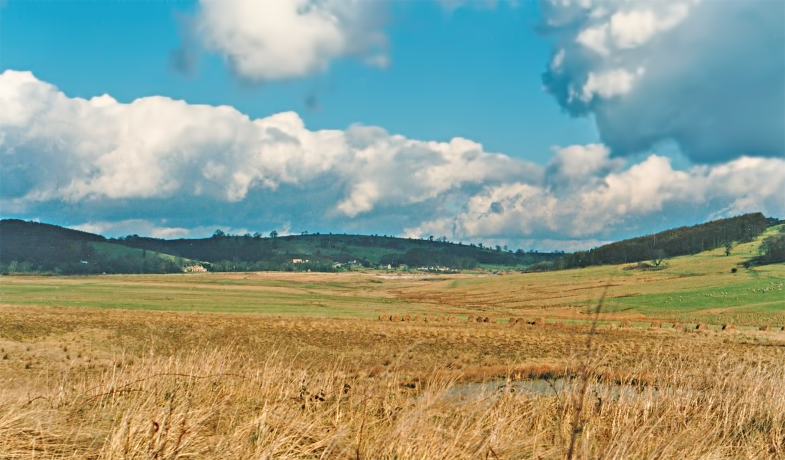
Carsington Roman Site - before the Reservoir Almost certainly the site of Lutudarum. Carsington just before the reservoir was flooded. We are on Oldfield Lane looking towards the villa site and recorded Roman settlement. The Roman road ran right to left in the middle distance. Image by Chris Stait.
|
Click for larger view |
 |
|||||||||||||||
Oblique 3D Lidar Image - Carsington Reservoir North The evidence for the climb up from the reservoir is very subtle but definite. The route cleverly used a spur of high ground to ease the gradient up to the heights of Carsington Pasture. With the help of a zig-zag on the steepest part they were able to keep the gradient to around 1 in 10. Without the sig-zag it would have been 1 in 5.5. Generally it would appear the Romans liked to keep gradients no steeper than 1 in 10 for wheeled traffic.
|
Click for larger view |
 |
|||||||||||||||
Oblique 3D Lidar Image - Carsington Pasture looking North Close-up of the zig-zag. It is somewhat disturbed but is exacatly what the Roman surveyor would have done to circumvent the steepest part of the climb.
|
Click for larger view |
 |
|||||||||||||||
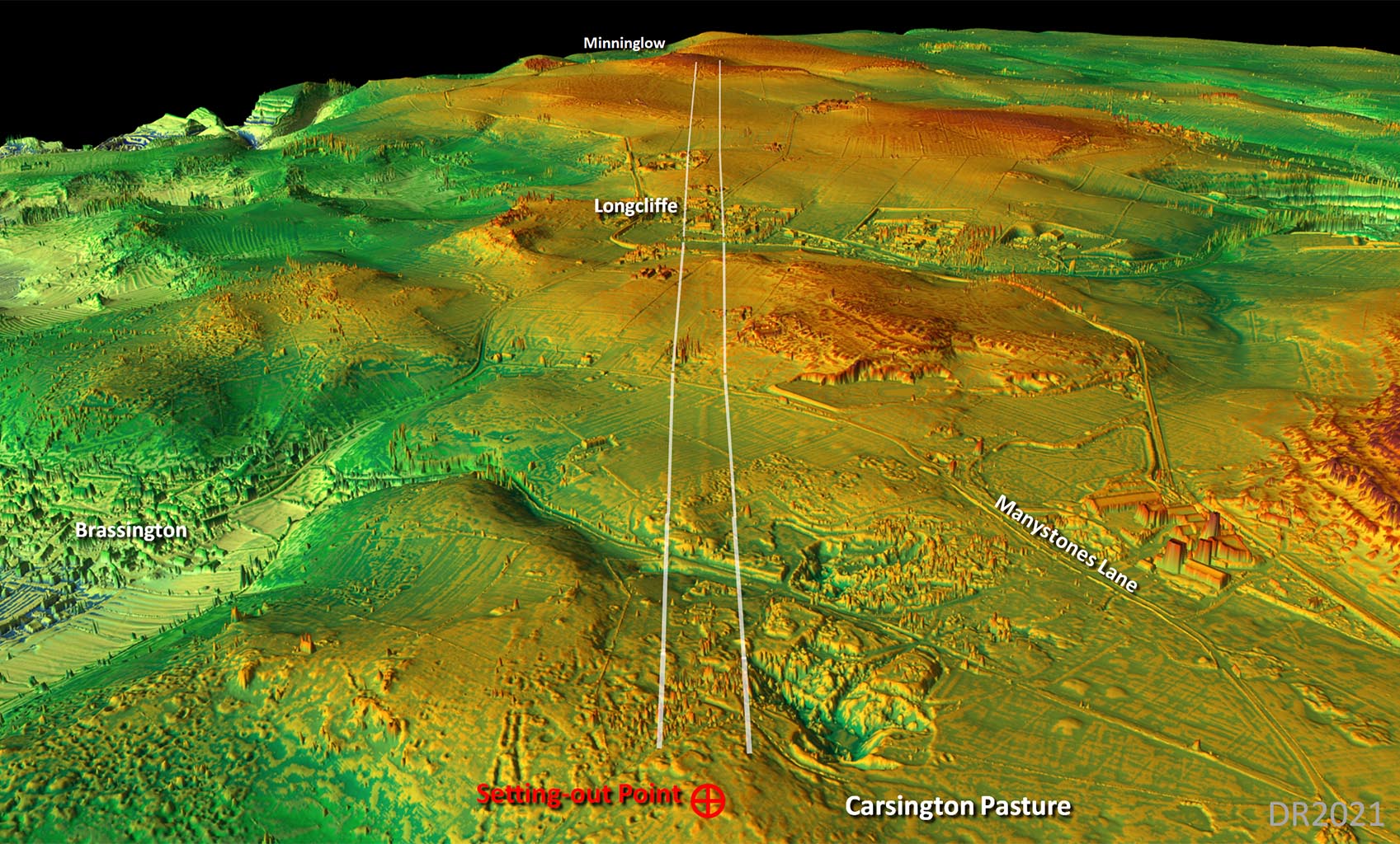
Oblique 3D Lidar Image - Carsington Pasture looking back (South) The section where the Roman road changed direction for Minninglow was obliterated by a large mine - Bees Nest Mine! This was and still is a high spot from which the alignments would ahve been established.
|
Click for larger view |
 |
|||||||||||||||
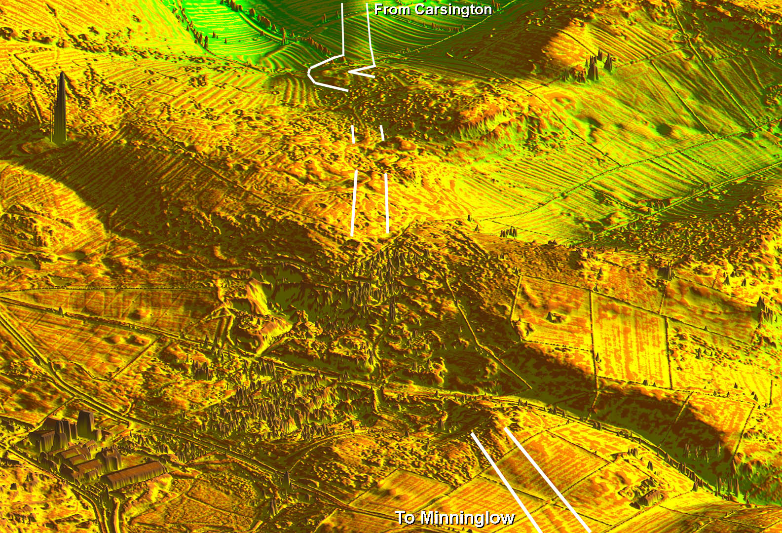
Oblique 3D Lidar Image - Carsington Pasture North Despite the mining over the centuries more than enough of the agger survives to confirm the route. A straight alignment was used all the way from Carsington Pasture to Minninglow.
|
Click for larger view |
 |
|||||||||||||||
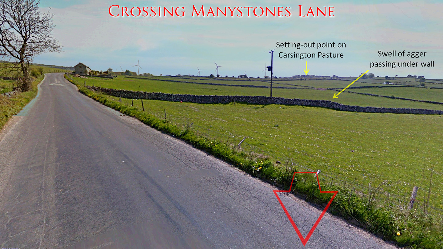
Crossing Manystones Lane Crossing Manystones Lane looking back towards Carsington Pasture the line of the Roman agger where it passes under a field wall is blindingly obvious. Google Streetview. |
Click for larger view |
 |
|||||||||||||||
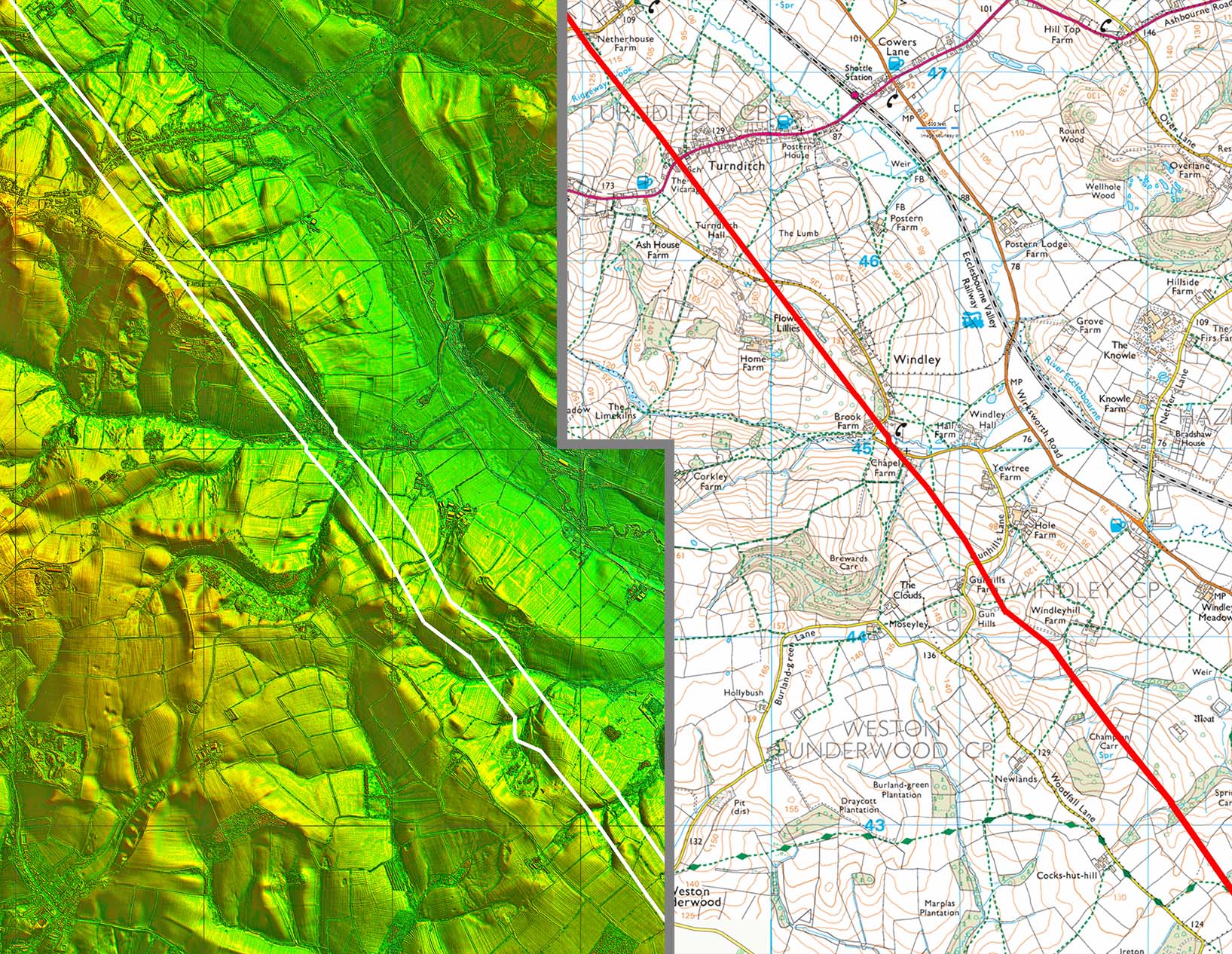
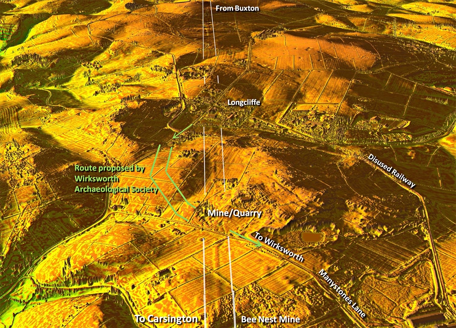
Oblique 3D Lidar Image - The Wirksworth Archaeological Society suggested route for the Street It was no doubt earlier failures to locate a direct route to Little Chester that prompted Wirksworth AS to search for an alternative route via Wirksworth. This was of course before Lidar became available. Their route is indicated in light green (see references below for the original online report). Coming from Buxton they suggested the Street first turned right (oddly the opposite direction for Wirksworth) and then turned left for Wirksworth and headed down Manystones Lane. In the fields I can see no evidence (ie between the green lines) supporting this. There does not appear to have been any mining or mechanical ploughing there to have removed all trace. On the other hand the actual route of the road survives (at least between mines) very very clearly and typically straight. Manystones Lane, by its general arrangement of branching off Brassington Lane, appears to be a relatively modern road bypassing Brassington Lane with its steep descent. Hardly a candidate for a Roman road.
|
Click for larger view |
 |
|||||||||||||||
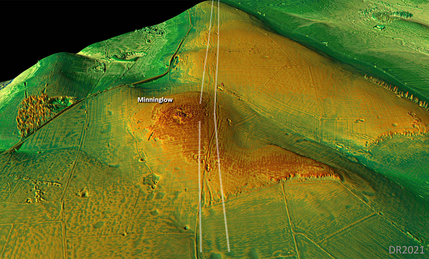
Oblique 3D Lidar Image - Minninglow 1 There was slight change of direction on the side of Minninglow and we leave the road heading off towards Buxton. It is typical of the Romans to respect an existing enclosure and pass to its side. I have seen this several times. North of Longcliffe and the mining area we are on the open uplands that have had little if any ploughing so traces of the road to Buxton are much more obvious. |
Click for larger view |
 |
|||||||||||||||
Oblique 3D Lidar Image - Minninglow Confusion There appears to be considerable confusion of where the actual Roman road lies passing Minninglow. Excavations have taken place here - not on the Roman line clearly revealed by Lidar - but on the track further east. They all found a not very thick road around only 3 metres wide. The latest in 2010 was by WAS who found it only 2.8 metres wide. This should have raised alarm bells as it is far far too narrow to be a Roman road. Presumably this is a post Roman diversion - it is far too insubstantial to be Roman. The actual Roman line is straight either side of Minninglow and clearly visible passing around 30 metres west the excavation site. In addition in 2025 there were 2 videos published on Youtube regarding the Roman road here and again the wrong location was given. |
Click for larger view |
 |
|||||||||||||||
Lidar Image & Route Map 5 The change of direction on Carsington Pasture was at a high spot as is usual but the sighting point on Carsington Pasture has been destroyed by the very large Bees Nest Mine. North of Longcliffe the road is well established and shown on modern mapping - well apart from at Minninglow!
|
Click for larger view |
 |
|||||||||||||||
NEW 3D Lidar video from Little Chester to Carsington Reservoir Make sure quality (settings) is HD 1080p
|
|||||||||||||||||
Oblique 3D Lidar Image - Pikehall The straight alignment from Minninglow pauses at Pikehall for a deviation to negotiate the contours there. The agger is particulaly clear here. The alignment resumes as soon as we are back on level ground. |
Click for larger view |
 |
|||||||||||||||
Lidar Image & Route Map 6 Plan of the above 3D view.
|
Click for larger view |
 |
|||||||||||||||
Oblique 3D Lidar Image - Arbor Low The Roman road from Rocester joins our road near Arbor Low. for the run to Buxton. Was the connection at Arbor Low a coincidence? |
Click for larger view |
 |
|||||||||||||||
Lidar Image & Route Map 7 This is where we are joined by the Roman road from Rocester
|
Click for larger view |
 |
|||||||||||||||
Oblique 3D Lidar Image - Benty Grange The Roman road runs to the left (west) of the field boundary - they both run parallel as far as the A515 and again the Roman road runs west of the A515. |
Click for larger view |
 |
|||||||||||||||
Lidar Image & Route Map 8 The road goes right through the middle of Middle Street Farm - very apt!
|
Click for larger view |
 |
|||||||||||||||
Oblique 3D Lidar Image - Great Low The long alignment from Minninglow finally ends and we turn for the run down to Buxton. |
Click for larger view |
 |
|||||||||||||||
Lidar Image & Route Map 9
|
Click for larger view |
 |
|||||||||||||||
Oblique 3D Lidar Image - Buxton looking back Messy DTM Lidar view looking back but it does reveal the likely route of the Roman road as it negotiates the contours into Buxton. |
Click for larger view |
 |
|||||||||||||||
Lidar Image & Route Map 10
|
Click for larger view |
 |
|||||||||||||||
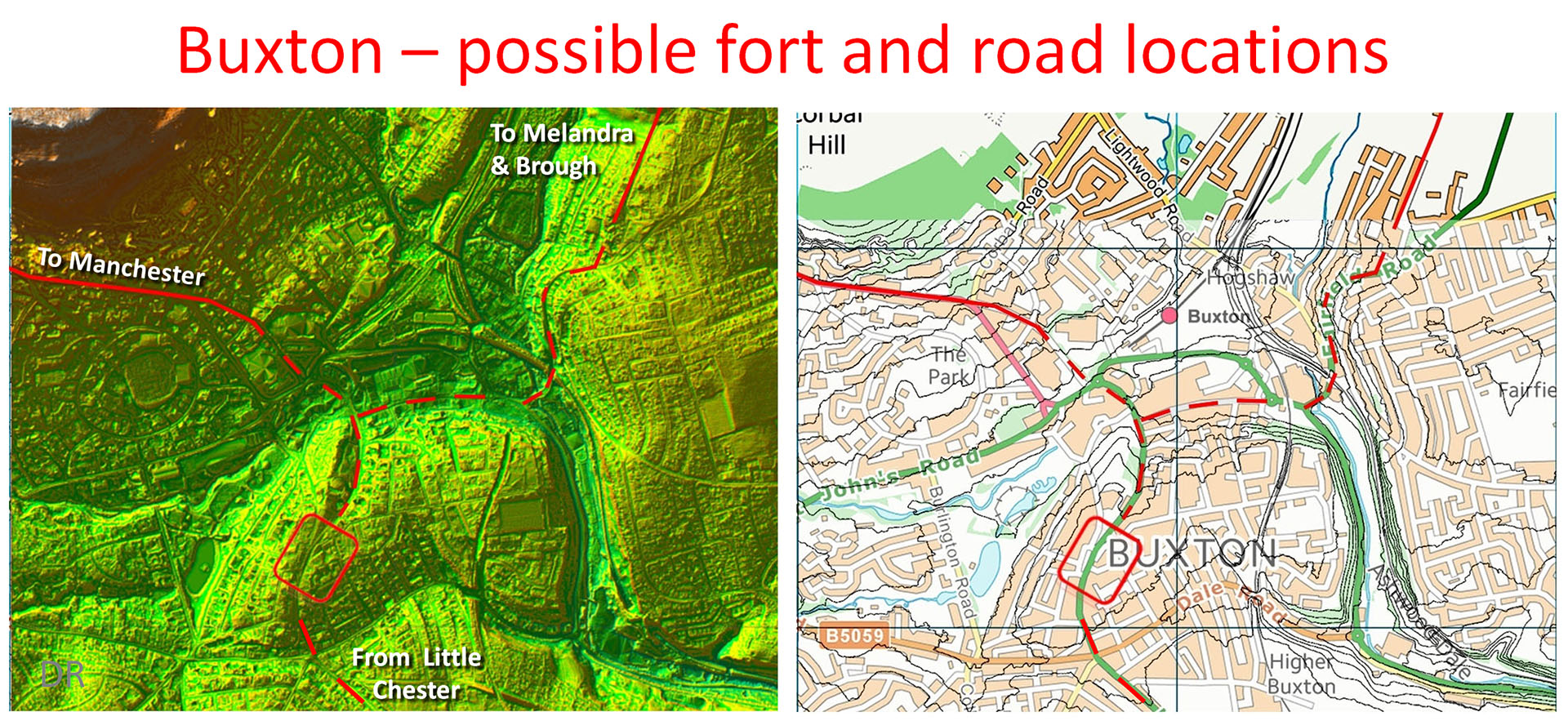
Possible Fort & Road Locations, Buxton The location of the fort is unknown. Based on the Lidar imagery the position shown looks the most strategic. In hilly Buxton here are not many flat alternatives plus it would provide a very commanding position..
|
Click for larger view |
 |
|||||||||||||||
Acknowledgements Raw LiDAR Data is Copyright Defra and processed using software by Mike Aerts. Mapping is Ordnance Survey Opendata, OS First Edition Map under CC-BY-NC-SA licence and Bing Mapping. References Roman Roads in Britain, I.D. Margary, 1957. Roman Roads in the Peak District, Carsington to Strutt's Park and Little Chester, Peter Wroe, Derbyshire Archaeological Journal, Volume 102, 1982 Excavations at Brough Field, Carsington, 1980, Dearne, M., Anderson, S. & Branigan, K., Derbyshire Archaeological Journal, 1995. Possible Roman Roads Between Derby and Kirk Ireton - Southern Sections of 'The Street'?, Adrian Farnsworth & Paula Whirrity, June 2006. Little Chester Roman Fort, Derby, Derbyshire, Archaeological Evaluation Report, Oxford Archaeology North, April 2014 The Roman Road between Little Chester and Longcliffe, David Ratledge, Derbyshire Archaeological Journal, Volume 141, 2021 Derbyshire HER - the definitive site for all historic sites in the county.
|
|
|
|
Last update: March 2026 |
© David Ratledge |